Puno & Lake Titicaca
Located at the southeastern end of the country, Puno boasts a most envious feature; it rests at over 12,000 feet on the shores of the amazingly beautiful Lake Titicaca. Not only is it the highest navigable lake in the world, but it is also the largest lake in all of South America. Among the most popular and recommended tours are those that take visitors on a boat ride to the floating Uros Islands. These islands are literally made from the totora reed, crafted as such for thousands of years by the native people that inhabit them.
Taking a stroll around Puno....
 |
| Puno's barogue cathedral located in the Plaza de Armas......Every Peruvian town has one! A cathedral and Plaza de Armas that is!! |
 |
| Something else every Peruvian town seems to have - the street corner secretarial pool. |
 |
| This however, as far as I can tell, is unique to Puno!! The Southeast Asian 3-wheeler tut-tut taxi....yes bye!! |
Taking a tour of Lake Titicaca's floating reed islands.......
 |
| Peru's famous floating islands are built using the buoyant totora reeds that grow abundantly in the shadows of Lake Titicaca. Here we take a tour boat out through the channel and onwards to the floating islands. |
 |
| Son paddles while father fishes....how did he manage to con him into that? |
 |
Lake Titicaca has some 41 floating reed islands on it that are an interesting experience for any traveller. These man-made islands have a fascinating history and story behind them. Although in modern times it can be argued that they are a bit touristy and somewhat artificial, it is also a fact that for thousands of years up to now, the Uros people have lived on and maintained these unique Peruvian islands, depending on the lake for their survival.
|
 |
| Quite the thriving community of islands......tourism is now big business! |
 |
| Bundles of reeds stacked teepee style. Not sure the purpose of the hanging reeds, but the patch of water behind is the fish holding tank. The locals catch fish from the lake and, while they are still alive, they place them in these small ponds within the floating island until they are ready for consumption. |
 |
| Paul and Art negotiating a sale from the purse lady! |
 |
| The lives of the Uros are interwoven with the totora reeds, which are partially edible and are also used to make their homes, boats and crafts that they churn out for the tourists. The islands are constructed from many layers of the reed, which are constantly replenished from the top as they rot from the bottom........this makes the islands "spongy" when walking on them, something akin to walking on your bed. |
 |
| A ceremonial reed boat used more now for tourist dollars than ceremony! |
 |
| We boarded the good ship "Two-Heads-Are-Better-Than-One" and was paddled to the waiting trinket sales people on another island. Nothing like spreading the wealth! |
 |
| Being from an island ourselves, we knew exactly how to fit in......buy stuff!! |
Today we head back on Lake Titicaca for a kayak to.........
Isla Tequile
Taquile is an island on the Peruvian side of Lake Titicaca, 45 km offshore from the city of Puno. About 1,700 people live on the island which is 8 Sq. Km.
The island was one of the last locations in Peru to capitulate to Spanish domination during the Spanish conquest of Peru. It was captured by Carlos V and eventually passed to Count Rodrigo of Taquila, after whom the island was named by the colonist. As the Spanish forbade traditional dress, the islanders adopted the Spanish peasant clothing. They are known for maintaining that as traditional dress today. They combine this with finely made Andean-style garments and accessories (poncho, belts, mantles, coca-leaf purses, etc.).
 |
| On Wednesday October 21st we were up at 6:00AM to go for a two hour road-trip to a place where we would start a kayak trip to Isla Tequile. This drive was interesting because we got to see parts of Peru most don't get to see, including the indigenous peoples living on the shores of Lake Titicaca. |
 |
| The age of innocence. |
 |
| Our kayaks are waiting. Notice the white sandy beach. Lake Titicaca seems more like a sea than a lake. Bright green algae blankets beach boulders and fills the air with a musty, seaside smell. Waves lap sandy beaches. The intense blue waters, as deep as 270 metres, stretch as far as the eye can see. |
 |
| As I was paddling thru some totora reeds I was startled by a large splash that turned out to be from the giant Lake Titicaca Frog, one of the largest aquatic frogs in the world. |
 |
| We land on Isla Tequile and gather our gear. The first part of this day adventure is over and we are anxious to get into hiking mode and explore the island. |
 |
| I'm immediately struck by how similar this island is to the Greek Islands in geography and customs. Notice the Mediterranean look/style in this sheep herder! |
 |
| Hiking?? We were told that we would be hiking on this island (???) Walking is more like it. No road but the rock paved trail might as well have been a road! |
 |
| This 'trail' snakes along the entire length (5.5kms) of the island. |
 |
| There are apparently no dogs on this island.....kids on the other hand there appears to be no shortage of! She bounced her ball happily along until we approached, at which time it came up to her mouth and that was where it stayed until we had passed her by! |
 |
| Tres amigos! The other Spanish words I learned were cerveza and banos! |
 |
| The only trees on this island are the Eucalyptus trees that line the path giving it an even more Mediterranean feel. |
 |
| The locals run their society based on community collectivism and on the Inca code ama sua, ama llulla, ama ghilla (Quechua meaning "do not steal, do not lie, do not be lazy). The economy is based on fishing, terraced farming horticulture based on potato cultivation, and tourist generated income from the approximately 40,000 tourist who visit each year. |
 |
| This archway and the one on the other side of the island are apparently all that remains from the ancient Incas. |
 |
| The hat and belt tells others on the island that this man is married, similar to the wedding ring worn elsewhere. |
 |
| The island's cathedral.... |
 |
| ....and the Plaza de Armas! |
 |
| The boats way down there was our destination point. In the meantime I thought this shitter was strategically placed to give the user an appreciative view, provided he kept the door open while sitting on the throne! |
 |
The island's second Inca archway. Notice the little girl!
|
We leave Lake Titicaca and continuing on we head for.........
Arequipa
Arequipa is the capital city of the Arequipa Region in southern Peru. With a population of 904,931, it is the second most populous city in the country. Arequipa lies in the Andes mountains at an altitude of 2,380 metres above sea level; the snow capped volcano El Misti overlooks the city.
The city has many colonial-era Spanish buildings built of sillar, a pearly white volcanic rock, from which Arequipa gets the nickname La Citudad Blanca (The White City). The historic centre of Arequipa was named a UNESCO World Heritage Site in 2000 in recognition of its architecture and historic integrity.
 |
| We boarded a bus in Puno and headed for Arequipa. Sitting up front on the upper deck of the bus afforded us the perfect opportunity to take a few pictures of the Andean Altiplano - a dry treeless moonscape where the Andes are at their widest. It is the most extensive area of high plateau (3,750 MASL) on earth outside of Tibet. |
 |
| El Mista, the active volcano that towers over Arequipa. To give you an indication of the size of this volcano mountain, it is about a 100 kms. to the mountain from where this picture was taken. |
 |
| So what kind of hotel does a person get for $23 per person in Arequipa? La Casa de Mi Abuela - secured hotel with extensive grounds, deck chairs, swings, loungers, small pool, restaurant, and live piano music....all this and a view of Chachani mountain (6,075M) in the background! |
 |
| The Arequipa Cathedral is neoclassical in style with an imposing facade that occupies all of the northern portion of the Plaza de Armas. Its construction started in 1621 and took 8 years to complete. It was destroyed by a fire in 1844 and was restored....it was flatten by an earthquake in 1868 and was restored.......another earthquake in 2001 toppled one enormous tower and the other slumped precariously and was restored. Jeeze bye, some things are just not meant to be! |
 |
| Night-time view! |
 |
| Arequipa's main Plaza de Armas showcases the sillar architecture with the colonnaded balconies overlooking the plaza on three sides. |
 |
| The Plaza de Armas at night! |
 |
One of the many churches that are crammed into this city!
|
The next day we head for.........
Colca Canyon
Colca Canyon is a canyon of the Colca River in southern Peru. It is located about 160 kilometres northwest of Arequipa. It is more than twice as deep as the Grand Canyon in the USA at 4,160 metres, however the canyon walls are not as vertical as those of the Grand Canyon.
The canyon is home to the Andean Condor (Vultur gryphus), a species that has seen worldwide effort to preserve it. The condors can be seen at fairly close range as they fly pass the canyon walls and are an increasingly popular attraction. 'Cruz del Condor' is the pass where condors soar gracefully on the rising thermals occurring as the air warms.
On the road to Colca Canyon.......
 |
| The vicuna is one of two wild South American camelids, along with the quanaco, which live in the high alpine areas of the Andes. Here they feed alongside the road (and railway)! |
The next day we headed for........
Nazca
As the Panamericana highway rises through coastal mountains and stretches across the arid flats of Nazca, you'd be forgiven for thinking that this desolate piece of earth holds little interest. And indeed this sun-bleached expanse was largely ignored by the outside world until 1939, when North American scientist Paul Kosok flew across the desert and noticed a series of extensive lines and figures etched in the sands below. What he stumbled across was one of ancient Peru's most impressive and enigmatic achievements: the world famous 'Nazca Lines'. Today the small town of Nazca is continually inundated by travellers who show up to marvel and scratch their heads over the purpose of these mysterious lines.
For our first day in Nazca we did a tour.......
 |
| We drove past some of the 'Nazca Lines' which may be as narrow as six inches or as wide as several hundred yards. Some run for many miles. The Nazca people created some of them by removing dark surface stones and placing them in the desired patterns. For others, they removed the desert's thin brown surface coating by walking or sweeping across it, exposing the lighter soil underneath. Because of the area's dry, stable climate, these light-coloured Nazca Lines have remained nearly unchanged for many centuries. |
 |
| Second stop was the Cantallo aqueducts that are still working after 2,000 years! |
 |
| The way to enter the aqueducts is by the spiralling ventanos (window), which local people use to clean the aqueducts each year.....we didn't crawl into them. |
 |
| There are eight aqueducts it this location......and now for the obligatory picture! |
 |
Apparently "they" say (whom ever "they" may be), that if you drink the water from the aqueducts you'll grow hair....or get the worms.....in either case it never happen.
|
 |
| From where we are we could see something completely different. How about the world's highest sand dune? Yep! That's it there: The Cerro Blanco Sand Dune, the highest sand dune in the world. At 2070 MASL it towers above the dark mountains in the foreground! |
Next stop.........
 |
| Our next stop was into the desert to visit some of Paul's friends....poor fella couldn't handle his beers! Actually may be due to his age, after all he be about 2,000 years old!! |
 |
| Well it seems that every ancient South American culture had their own interesting way of disposing with the newly departed. The Nazca peoples mummified theirs!! |
 |
| The Nazca built huge necropolises of underground tombs in the desert sands where they interned the mummies in small rooms built of mud brick. The mummies were usually wearing ceremonial clothes, with a few pots and maybe their sacrificed kids thrown in for decoration. Unfortunately, grave-robbers discovered the burial fields in the shifting sands long before the archaelogists. By the time the authorities showed up, most everything was gone. |
 |
| Dreadlocks were the order of the day.....and this guy had quite the head full of them. |
 |
| The sands of Chauchilla are covered with the refuse of decades of grave-robbery bones, skulls, hair, broken potshards, ancient cotton and textiles all litter the sands. The grave-robbers were looking for gold and silver and threw everything else away. |
 |
| We found this piece of wrapped textile in a place that had a particularly large pile of bones and other matters. Within the wrapped textile was dried coca leaves and a limestone (used to neutralize the coca). The shards of pottery was also found in the same area. |
 |
| Paul that is just wrong....good looking jaw-bone though! |
Our final stop of the tour.......
 |
| The Cahuachi ruins which are still undergoing excavation. It consist of several pyramids and a mummification centre. |
The next day we fly over the Nazca Lines........
 |
| The four of us are going to get in this extremely small plane and our pilot must weigh in at 300 pounds......sure we'll never get off the ground! |
 |
| "ART. What music channel you listening to?" |
 |
| "OK boys, who farted?" |
 |
| Spread across an incredible 500 sq km of arid, rock strewn plain in the Pampa Colorado, the Nazca Lines remain one of the world's great archaeological mysteries. Consisting of over 800 straight lines, 300 geometric figures and, concentrated in a relatively small area, some 70 spectacular animal and plant drawings, the lines are almost imperceptible at ground level. It's only when viewed from above that they form their striking network of enormous stylized figures and lines. Notice the truck in the picture for a sense of scale. |
 |
| The figures are mostly etched out in a single continuous lines, while the encompassing geoglyphs form perfect triangles, rectangles or straight lines running for several kilometres across the desert. Notice the Fish? |
 |
| The Nazca Lines attracted public attention not long after the heyday of UFO sightings began. In the 1950's, as more and more books and magazine articles addressed UFO's, some writers looked back to ancient history and mythology for evidence of early space visitors. In an article in the October 1955 issue of Fate, James W. Moseley suggested that since the markings were largely invisible from the ground, the Nazca people must have "constructed their huge markings as signals to interplanetary visitors or to some advanced earth race, that occasionally visited them." this figure of an "astronaut" didn't help in lessening that theory!! |
 |
| The Spider at 46 metres long! |
 |
| Coming in at 110 metres is the Monkey. Since there are no monkeys in this region the theory is that it was based on a gift from a traveler from the Amazon Basin. |
 |
| Again another species not from the region is the Hummingbird (96 mts). I consider these lines as one of the greatest example of leadership skills. Some person was able to convince great masses of people to walk to the middle of a very hot and very dry desert and then instructed them to etch a 96 metre hummingbird....a bird they never saw or heard of before. As well they will never get to see and appreciate their creation as the only way to see something like this is from the sky! |
 |
| Now I ask you: Doesn't these large lines look like runways? |
 |
| Hands down that this is.....well Hands of course! 45 metres in size. The tower was built so that land based tourist could see a couple of the figures. |
Later that day we went for a dune buggy ride......
 |
| A group of us headed for the sand dunes that are common in this area, but first we stopped at this; the largest and most impressive aqueduct that we've seen. A little oasis smack-dab in the middle of the desert. This is also the place Art got sick and threw up.....just saying! |
 |
| The oasis created by the aqueduct had the only trees around for miles. |
 |
| Just around this turn and we hit the Dunes.....similar to the White Sahara Sea in Egypt. |
 |
| And there she be. A BIG sandbox to play in!!! |
 |
| The dunes are bigger and steeper than any picture could ever do justice to....... |
 |
| .....perhaps this picture does some justice to the size of the dunes!! It's a long way down to the valley below! |
 |
| Paul demonstrating his dune-surfing technique!! |
 |
| Living on the edge! |
 |
| Strapping up! |
 |
| The newest member of the Crazy Canucks Sand Surfing Team....Art Clarke! |
 |
| Ah yes! Flat tire and unable to jack her up because of the soft sand, so we had to dig down, not an easy task since all the sand kept flowing back into the hole! 2 1/2 hours later we were back on track! |
The next day we head for.......
Lima
On its surface, Lima is no thing of beauty. A sprawling desert city clinging precariously to dusty cliffs, it spends much of the year marinated in a perpetual fog that turns the sky the colour of styrofoam. It is a loud, chaotic and gritty; much of its architecture is bulky and grey. Foreign travellers tend to scuttle through on their way to more pastoral destinations in the Andes.
With a municipal population of eight million or a population density of 3,000 inhabitants per square kilometre, Lima ranks as the 16th most populous city in the world. We decided to stay in the more user friendly upmarket neighbourhood of Miraflores.
 |
| The cliffs of Lima. |
 |
| Exploring from our hotel brought us to the Miraflores cliffs where we saw the paragliders. I wanted to really do this but was under the impression that the flights would be cheaper in Ecuador, so I decided to wait until I got there. Unfortunately there was no paragliding in Ecuador, so I missed out altogether. |
 |
| Doing the tourist thing! |
 |
| Da bye's get together to say goodbye to Art (he's heading back home to Canada) and welcome Don Peddle who will be joining Paul and I for the next month of travel in Ecuador! Cheers byes! |
The next day we head for.........
Mancora
Mancora is a town and beach resort in northwestern Peru. The Pan-American Highway serves as Mancora's main street. The area is known for its attractive turquoise beaches and good waves, making it a surfing destination. This beach location is favoured by two ocean currents year round giving it a tropical-dry climate with ocean waters averaging around 24C.
 |
| The Mancora fishing fleet was stationed just off from our hotel. |
 |
| The Lonely Planet writes the following about our hotel: "At the south end of town where the Antigua Pan-American branches off, this hotel is far enough away from town to be silent but still closer enough to allow frequent visits. White brick all around and designed with a raunchy mood in mind, this laid-back place has a great restaurant, a tiny pool, a colourful bar, foos-ball tables and lot's of art gracing the walls. The rooms are comfortable but possibly overpriced." |
 |
| Lonely Planet may have thought that this hotel was over-priced but I only paid $15, so I thought it was reasonable! |
 |
| Don and I had had enough of Lima and flew north to sit in the sand, taking surfing lessons, go zip-lining, drink cold cold beer and look at basking babes. Paul would catch up with us in a few days after Art flew home. |
 |
| This is surfers paradise, and these constant waves are the reason. Mancora was hosting the weeklong Women's World Surfing competition the day we left town. |
 |
| Even though this small community annually attracts 350,000 visitors, which for a town of 10,000 people, is a lot! It still maintains a large fishing fleet. Here, a fisherman on a raft paddles by a fishing boat full of pelicans. |
 |
| And here a poorer fisherman cleans his catch on the beach. |
While in Mancora we go zip-lining.......
 |
| Don and I geared up and ready to go! We had to climb a very steep and fairly long hill under 32C heat to get to this point! |
 |
| EIGHT HUNDRED METRES over the desert valley. 800 metres.....WOW.....so far away I can't even see the landing platform. |
 |
| Don coming in low! |
 |
| Getting ready to launch. |
 |
| Take off! |
The next day we head for Ecuador.......
 |
| The border with Ecuador: chaotic, congested and completely open....we simply walked across the border. No border guards, no hassles, no pain, until we got to the immigration office and realized we had to go back across the border into Peru and get an 'exit visa' stamp! |
Well folks that's it for Peru. See you in Ecuador!
Diary Entry: Thursday October 1, 2009 9:29AM: We arrived in Lima last night and arranged a hotel at the airport in Lima. Took the same taxi in the morning back to the airport and now we're in the air on our way to Huaraz. From the airplane I'm catching my first view of the Andes.
Diary Entry: Friday October 2, 2009 1:42PM: Interruption in my notes from the plane. So here I am in Huaraz. We actually arrived here relatively early on Thursday so we had sufficient time to wander around. This town is situated right in the Andes and the views of these majestic mountains are spectacular. Even as I sit here in the Backpackers Hostel writing this, I can see the snow capped peaks of the Cordillera Blanca.
Yesterday (Thursday Oct 1, 2009) we arranged our trek into the mountains. It will be $110 for 4 days and it will be starting at 6:00AM Saturday morning.
We found the market and had lunch in there. Quite the spot.......very similar to just about every other 3rd world market I've been in. Today we have to go over there and get some water and food for tomorrow.
Later yesterday (October 1/09) we went to the X-treme Bar. This was a really neat spot with great music, English speaking Peruvians and cold beer. This cold beer is important because we only found a few places with "cold" beer. I think I got home at 1:15AM.
Got up this morning and after grabbing a shower we headed for the Californian Cafe for breakfast. Afterwards we found an internet and booked flights for our next part of the trip to Cuzco.
Diary Entry: Saturday October 3, 2009 4:41PM: We just arrived at our first campground about an hour ago. This is an awesome place situated in the Cordillera Blanca with the white peaks on three sides!!
Today we got up at 5:15AM this morning and headed to the trekking shop. At 7:15AM we boarded a local bus to drive up into the mountains. At about 11:00AM we started out trek. You quickly realize how altitude affects you when you are trekking at these heights.
Our camp is situated at 3,900mts and we trekked 9 1/2km. Not a hard climb, but I noticed the shortness of breath very quickly. We are the only ones camping here. We don't know if others will come later or not, but the sun is sinking fast. Tea is served - so I'm signing off.
Diary Entry: Monday October 5, 2009 7:47AM: Much warmer last night then the night before even though we're 300 metres higher.
Yesterday (Sunday Oct 4, 2009) we left first camp and hiked up and over the Punta Union Pass at 4,750 metres. The first part of the hike was relatively easy going but when we hit the mountains to go for the pass, things quickly changed. The boys here are calling it breathtaking and that is the perfect description in more ways then one!!
The hike up was draining in every sense.....albeit the views were spectacular!! At 4,750mts this can be a kill zone and that's exactly what happened. Our muleteer was following us with our two mules and a horse, loaded down with our gear. The poor horse never made it. It had a heart attack on the pass and croaked. Of course we didn't know this until we were at our camp and no gear. Our guide went back and got the two mules but as luck would have it my sleeping bag was with the horse. It was a pretty intense few hours before the muleteer turned up in the dark with all the pack horse gear on his back. I say it must of weighed in at 120lbs. Of course this means we must carry our own gear for the next two days. Just as a side note; we saw two skeletons of other mules at the pass as well.
While we were at the pass we were next to the glaciers and periodically a landslide would happen from junks of glacier splitting off. Loud bang, followed by rock and ice.
The rest of our hike that day was all downhill. Tea time so signing off.
Diary Entry: Tuesday October 6, 2009 7:03AM: Woke up this morning at 6:16AM for our final 5km hike back to civilization. Last night we had heavy rain for about an hour. It was the first time since we've been here. Our tent leaked a little but not enough to make things wet....just a little damp.
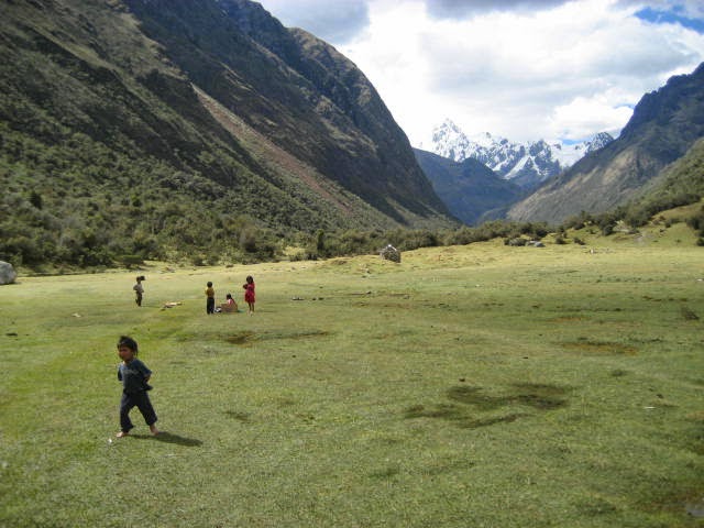
Yesterday (Monday Oct 4, 2009) we left around 8:40AM for a long hike to this camp (about 12km). Fortunately it was only flat or down going so it wasn't bad. Paul, Adam and Mark hiked up to a lake while Karla, Art and myself continued onwards. We saw our first llama's yesterday!! They look somewhat like camels!!
DIARY ENTRY: Thursday, October 8, 2009 7:44PM: Just booked our "expensive" trek to Choquequirao for 8 days!
On Tuesday (October 6, 2009) We finished our trek and headed back to Huaraz for the night. Even though I was beat to a snot, I still ended up at the X-Treme Bar for a few beers. Art turned up later, just as Paul was heading back to the hotel. I think it was around 2:30AM when we got home. :)
The next day (October 7, 2009) was a travel day from Huaraz to Lima to Cuzco.
Cuzco is a beautiful city. We are staying in the San Blas area and it's about 5 minutes walk to the main square. Later we went to a bar named The Muse. Had a blast and I think it was 4:00AM by the time we got home....and of course that means it was 12:30PM before I got up.!!
DIARY ENTRY: Saturday October 10, 2009 10:44AM: Arrived in Cachora getting ready to start our hike to Choquequirao. The ride to Cachora was about 3 1/2 hours and now we're waiting for our horseman to round up the pack-horses and head out.
Yesterday (Friday October 11/09) was a down day in Cuzco. Good thing, cause I was hung over and didn't crawl out of bed until 1:30PM. The night before we went to the Bullfrog for beers and pool and then on to Mamma Africa's Dance Bar. It was their grand opening!!! Good times!!
We spent the rest of the day wandering around town looking for hiking poles. We also had to meet with our guide and pay for the remainder of the trip and pack! I also took care of e-mails (I had somewhat neglected these). Afterwards I headed for bed as we had to get up at 5:00AM in the morning.
DIARY ENTRY: Saturday October 10, 2009 6:42PM: Arrived at Camp 1 of this trek. It is a very organized place with a shower, bathrooms and beer!! Paul is in his glee! Our hike was supposed to be 16km long but it was actually 20kms. I was very grateful to wash the dust off of me.
There are a lot of people staying here but most (if not all) are only going to Choquequirao. Todays hike started in Cachora and it was a slow climb to the mountain pass (3,100mts). The next leg was all downhill but not an easy one.....very steep....a lot of zig-zagging.
DIARY ENTRY: Sunday October 11, 2009 6:29PM: Sitting in the meal tent waiting for supper now.
We were awake at 4:30AM and on the trail by 5:10AM. This was one of the hardest climbs I have ever done. First we descended 200 metres to the Apurimac River, crossed over a suspension bridge and started the major 16km walk up one of the steepest hills I have ever went up. I couldn't for the live of me get my breathing down and I fear tomorrow is gonna be worst.
We finally reached Choquequirao at 2:00PM. I was so tired I couldn't do nothing but lie down and take a nap. At around 3:00PM I got up and went for a walk around the ruins. After a couple of hours we headed back the way we came for 2kms to our camp.
DIARY ENTRY: Monday October 12, 2009 5:34PM: Happy Thanksgiving Day!! Here we are in Maizal and there is a turkey walking around. For the right price he's ours!!!!
So today we started off real real early (4:00AM). We climbed about 300 metres to the second pass of the trip and then it was downhill....YAAA!! While walking down the steep hills of this mountain we came across the ruins of Pinchinoyoc.....very impressive. These terraces are built on the sides of cliffs and only a very small portion of the ruins here have been excavated. They are all part of the Choquequirao city which makes Machu Picchu about a third the size of this lost city.
At the end of the trip downhill we reach Rio Blanco River. This small 'river' snaked thru the valley at 1,900MASL. It was very hot out (35C) but the river was cool (glacier run-off).
When we arrived at the valley floor the very first thing we did was strip off and go for a cool dip....and it was amazing!! Afterwards we had lunch and at 11:30AM I went for another dip before the longgggg climb back up the next mountain to Maizal (3,000MASL).
This trek up was gruelling because of the heat, but thankfully I've started to get my wind.
Maizal consist of 3 - 4 huts but it has 1.1 litre beers and we all sat down and enjoyed one!! The scenery here is spectacular. This is a small community of wealth, as is evident by the number of hens and goats around.
Signing off.....tomorrow we're told it will be an easier day!!
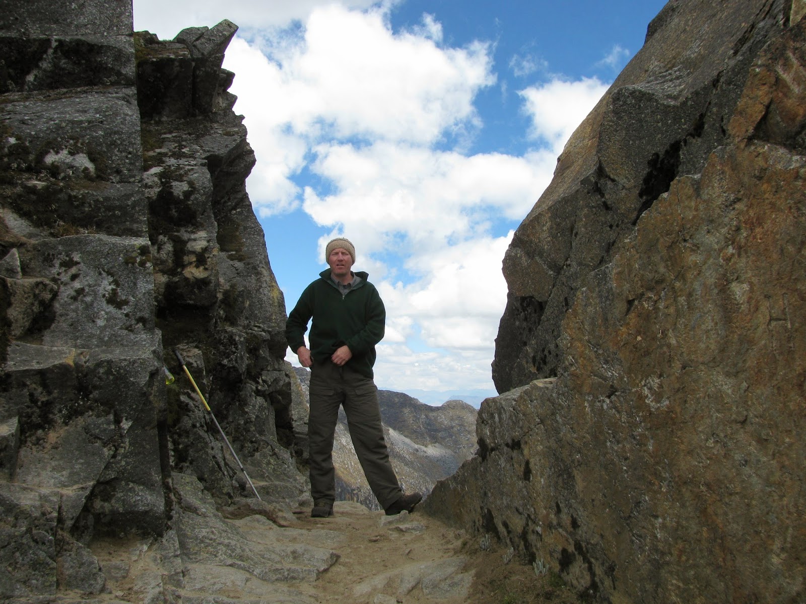
DIARY ENTRY: Tuesday October 13, 2009 3:36PM: We arrived in Yanama at around 2:15 after climbing over the Andean Puna Pass at approximately 4,200 MASL. I wasn't feeling the greatest today and I struggled up this pass.....maybe I'm just out of shape, who knows?
The walk down from the pass was pretty spectacular to say the least. Snow capped mountains and cliff-hanging trails.
Yanama is one of these villages (about 15 mud huts) that is isolated from the world. No roads, only gruelling trails....but surprisingly they have cold beer and this is a blessing after such a long hike.
DIARY ENTRY: Wednesday October 14, 2009 4:37PM: I got to sleep in this morning (5:35AM). YIPPEE! However I must confess I woke up feeling somewhat ill. Had a few good dry heaves and I was good to go.
Today is supposed to be an easy day and in a way it was, but while the grade was gentle, the altitude made up for the gentleness. We had to go over another mountain pass at 4,668 MASL. This is our fourth high pass that we went over on our trip.
From Yanama we hiked for about 7 hours up to the pass and back down to the village of Totora. I'm getting trekked out now!! Tomorrow is our last real day of hiking!!
DIARY ENTRY: Friday October 16, 2009 7:40PM: So here it is Friday night and we appear to be settled in for the night....am I getting old?
Everyone (except me) insisted on an early rise so that we can beat the crowds to Machu Picchu....right! I expect the real reason is because our guide has a 2:00PM train and wants to be down and out long before then. It has been my experience in the past that afternoons are better times because people get up early to "beat the crowds". C'est la vie.
Getting back to events on the trail....so from Totora on Thursday
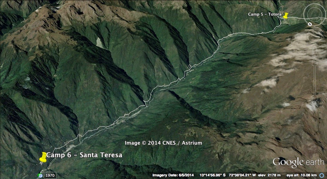
(Oct 15, 2009) we trekked for several hours.....mainly downhill to La Playa.
La Playa is a small simple town that was built up on a beach from the Totora River, however the river has long ago washed the beach away. Now it's a disgusting dirty town where the only good comment I can think of is that the beer was cold. We opted to leave and go to the hot springs the other side of the village of Santa Teresa. This turned out to be a very good decision. Here was a place of spa-type qualities and again, cold beer!! The place had 3 pools of which one was very large and they were all of varying temperatures. I think I floated in the middle-temperature pool for about 2 1/2 hours. It was soooo relaxing, especially after 6 hours of hiking.
Later that night we sat around with Benni (cookie) and Dion (guide) and drank them 1.1 litre beers!
Today we were up early (for no apparent reason) and took a taxi to the hydro-electrical plant where we proceeded to walk the train tracks for way too many hours. This type of hiking is uncomfortable and boring. Regardless, we arrived in Aquas Calientes at around 12:00 noon and Paul and I went exploring a little while Art took a nap. We had to be at the train station for 5:30 to get our backpacks and that is where this diary entry ends.......now at 8:01PM Friday, I'm sitting here in bed while the boys are snoring away....lol, oh well!!
DIARY ENTRY: Monday October 19, 2009 2:19PM: Sitting in the lobby of the Monarea Hostel waiting for 10:30 when we have to be at the bus station to catch our bus to Puno.
We got up at 6:30AM on Saturday
(Oct 17, 2009) to take the our tour of Machu Picchu. The bus ride was about 20 minutes but since it was raining the line-up to the site was relatively small.
The site is impressive, no doubt, what with the rain and mist it gave it a mystical look and feel to the place. Our tour was about 2 1/2 hours long and by the time that was over the sun had come out. We got a couple more shots and headed back to town to get our train tickets, only to find the fax with the confirmation #'s had not arrived. After a couple of tense hours seeing if we would get a train, Dion came thru and we were on our way back to Cuzco. We arrived back at about 10:30PM. A long and tiresome trip but alas we made it!!
DIARY ENTRY: Wednesday October 21, 2009 8:00PM: Back from kayaking today on Lake Titicaca, the highest navigable lake in the world!
We took the overnight bus from Cuzco to Puno and arrived here at about 7:00AM. We took a hotel from a bus tot and made arrangements to go out to the floating islands.
At about 3:30PM yesterday (Oct 20, 2009) we took a boat out to the floating islands and spent a couple of hours out there. They were interesting and worth the visit, even if only for the photo-op. The islands were spongy to walk on and it is an interesting lifestyle for sure. The islands were floating in 14 metres of water.
Today we were up at 6:00AM and took a 2-hour drive to get our kayaks. The kayak was interesting until we made for the 6km crossing to the island (Taquille Isla). Crossings are always boring, however after a hour we made the island and this was a very interesting place. It reminded me very much of a Greek Island. Had a feed of fresh trout there and took the 2 hour boat ride back to Puno.
DIARY ENTRY: Saturday October 24, 2009 6:45PM: Just arrived at some village.....don't know the name of it.
Took an early bus to Arequipa (Oct 22, 2009) and arrived at around 2:00PM on Thursday. We had already made up our minds that we would upgrade to a better hotel for a couple of days......so we did. The place we got was $70.00US a night but among the three of us it only worked out to be $23 and it was a beautiful spot. It even had a swimming pool even though we didn't avail ourselves.
The night we went out for a few swallies with an Aussie (Ralph). Not a late night simply because both Paul and Art were suffering from stomach problems.
Yesterday (Oct 23, 2009) we decided to skip El Mista and instead book a 3 day/2 night trip to the Colca Canyon. It's the deepest in the world!!
Today we were picked up early, after spending a relaxing day yesterday. Our guide took us to some strange rock formations before heading for the canyon....a four hour drive.
So now we're here at our hotel and I have severe stomach cramps and diaherria. Shits to be me....lol.
DIARY ENTRY: Thursday October 29, 2009 10:32AM: Just picked up some water for the bus ride to Lima. Should be about 5 hours.
When I last signed in, I was vomiting and suffering from the shittens and had a very high fever. Later that night, with about 60lbs of blanket on me, my fever broke, and by morning the severe cramps had ceased, so I figured with the help of Imodium I could make the hike into the canyon....after all it was all downhill.....besides what were my options?
The canyon was spectacular , as expected. And I was right, the hike down was easy enough. I did keep wondering how the hike back up would be though! We made it down in about 2 1/2 hours (stopping for numerous photos) and took a quick dip in the spring fed swimming pools. I wasn't up very late (7:30) even with a few beer!
On Monday (Oct 26, 2009) came the hard part. We were up at 4:00AM and started climbing before the sun came up. After two days of not eating and dehydration from being sick, I was feeling it, however I still made the climb in 2 1/2 hours but I was a sick-puppy by the time I hit the top.
Gotta go now and get our taxi to the bus station.....back in a minute!
DIARY ENTRY: Thursday October 29, 2009 10:56AM: Quick, albeit expensive, ride to the bus station. After the trek to the top of the Colca Canyon, we took our bus back to Arequipa.
We had a short few hours wait at our hotel, grabbed some supper and then, at 10:30PM, headed for the overnight bus to Nazca. After an uneventful night ride here (we got in around 6:30AM), we found a hotel and set out to book some site-seeing tours. We found a place that would take us to see the aqueducts (impressive, but nothing to get excited about), the mummies (much more impressive) and finally the pyramids (again not very impressive) but the graveyard heap along the way was. The day ended with a few beers and an early night.
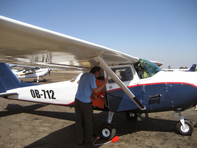
Yesterday (Oct 28, 2009) we had decided we would fly over the Nazca Lines. The three of us piled into the tiniest Cessna I've seen with our fat pilot and off we went!! Now the lines were very impressive and the plane ride a lot of fun as well. The Lines are scattered over quite the distance and it makes you wonder why people of ancient times would walk such a distance to build such a desert tapestry, especially since they couldn't see their handy work???
In the afternoon we headed for the dune buggy and sand dunes. The ride to this place took us right pass the pyramids again (still not impressive) and onwards to the dunes (very impressive). We spent a hour or so up and down the very large dunes and it was a wild and crazy time!
Afterwards we gave a try at sand-boarding. I did this in Egypt and met with the same success...that being no success at all. Actually fell and hurt my tailbone.....now sitting has become a chore. Decided at that time the best way to the bottom was to lie down on the friggin thing!
All this was going great until our dune buggy got a flat.....why does always happen to me?? Two hours later we had finally dug the sand down far enough to put the tire on and get out of the desert before night fall.
DIARY ENTRY: Sunday November 1, 2009 5:06PM: Here I am now in Mancora in a little vista on the beach. Amazing the diversity that we have experienced in this country so far, from high mountains to pristine beaches.
We arranged to leave Nazca for Lima the next day (Friday Oct 30, 2009). Although it was supposed to be a 6 hour bus ride, it was actually 7 1/2 and we didn't arrive in Lima until 7:30PM. Got our room and headed over for Don. We had supper, a few beers and then called it an early night.
The next day (Oct 31, 2009) was a total chill-out in Lima, which isn't really chilling out at all....big city and noisy. Did some shopping, packed a few things into a box to ship back home, and that was that. Since Don and I are heading out the next day we went out partying with Art. Didn't have to get up early the next day so we stayed out until 3:00AM.
Don and I were flying out at 7:00PM to Tumbes and then the plan was to take a taxi/bus to Mancora, beach town, bikini clad babes, etc etc. By and large things stuck to the plan and we arrived in Mancora today at around 12:30 this afternoon. This is a typical surfer town, cheap hotels and young hippie types. We plan on spending the next few days here while waiting for Paul to see Art off and then he's going to meet up with us in Tumbes.
DIARY ENTRY: Tuesday November 3, 2009 10:04AM: Waiting now to head for the bus back to Tumbes. We have to be there at 10:40 and it's a 20 minute walk so I have limited time.
On Monday (Nov 2, 2009) we were picked up at our hotel and headed into the back country to check out the zip-lines. There are four in total and the longest was 800 metres....dat's long!!!
Mancora is hosting the Ladies World Surfing Championships this week....but we leave today which is the day the elimination rounds start.
Anyway, hopefully we are off to Ecuador today and the beginning of a new adventure.


No comments:
Post a Comment