
"The whole object of travel is not to set foot on foreign land; it is at last to set foot in one's own country as a foreign land."
G. K. Chesterton
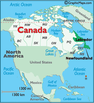
Over the years I have had the opportunity to explore over 40 countries in the world but I have never really explored my own country - Canada. Its ten provinces and three territories extend from the Atlantic to the Pacific and northward into the Arctic Ocean, covering 9.98 million square kilometres (3.85 million square miles), making it the world's second-largest country. Given that this great country is SO large, Melanie and I decided to purchase a 20 foot travel trailer and set out to explore. We started our adventure in our home province of..........
Newfoundland & Labrador
Newfoundland & Labrador is the most easterly province of Canada. Situated in the country's Atlantic region, it comprises the island of Newfoundland and mainland Labrador to the northwest, with a combined area of 405,212 square kilometres. The far east of the western world, it is a special place. You'll find no concrete jungle here. Instead, you'll find a place where the kindness of the people warms your heart, where spectacular scenery and wind-swept shores takes your breath away, and where friendly faces, culinary delights, colourful culture and characters make this place special.
In 1496 John Cabot obtained a charter from English King Henry VII to "sail to all parts, countries and seas of the East, the West and of the North, under our banner and ensign and to set up our banner on any new-found-land" and on June 24, 1497, landed in Cape Bonavista. Later in 1499, Portuguese mariner João Fernandes Lavrador explored and mapped this coast, his name appearing as "Labrador" on topographical maps of the period. Even later, Sir Humphrey Gilbert, provided with letters patent from Queen Elizabeth I, landed in St John's on August 1583, and formally took possession of the island for England. This former colony and country, Newfoundland & Labrador became the tenth province to enter the Canadian Confederation on March 31, 1949.
In 1496 John Cabot obtained a charter from English King Henry VII to "sail to all parts, countries and seas of the East, the West and of the North, under our banner and ensign and to set up our banner on any new-found-land" and on June 24, 1497, landed in Cape Bonavista. Later in 1499, Portuguese mariner João Fernandes Lavrador explored and mapped this coast, his name appearing as "Labrador" on topographical maps of the period. Even later, Sir Humphrey Gilbert, provided with letters patent from Queen Elizabeth I, landed in St John's on August 1583, and formally took possession of the island for England. This former colony and country, Newfoundland & Labrador became the tenth province to enter the Canadian Confederation on March 31, 1949.

**********
I should note that we have lived for the last 40+ years in St. John's, the capital city of Newfoundland & Labrador, and as such I have not included any reference to this phenomenal city in this blog as there is an over-abundance of information available to those that seek it.Furthermore, I have not included any reference to the world class East Coast Trail system. This groomed 300 km trail was declared the #1 hiking trail in the world by National Geographic magazine in 2012 and as such there is plenty of information on this trail available to those that seek it.
**********
 |
| Melanie & moi on our maiden trip in our 20ft travel trailer. |
To start our journey we make our way to Canada's oldest community..........
Cupids
Explorer John Guy and his backers brought a boatload of settlers to New-founde-lande and established a plantation in what was then known as Cuper's Cove in 1610. It was the second English colony in North America after Jamestown, Virginia, founded in 1607.
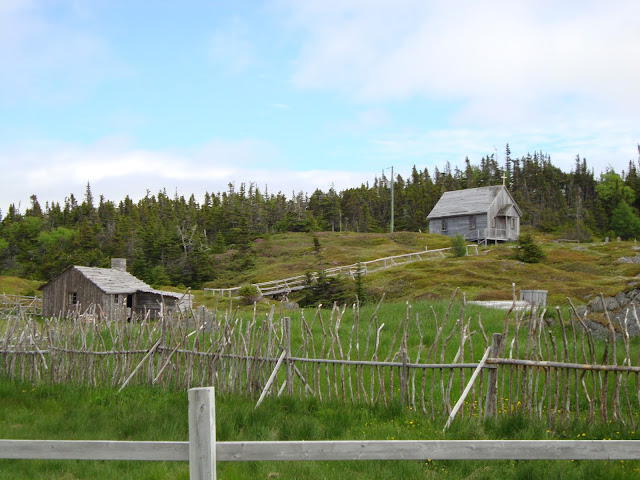
The people of Cuper's Cove cleared the land and constructed dwellings, fortifications, and boats. They fished, farmed, explored for minerals, and tried to establish fur trading with the Beothuk, the now extinct aboriginal people.
The colony was plagued by pirate attacks including the ‘Pirate Admiral’ Peter Easton, as well as the harsh conditions of early settlement.
The first recorded birth of an English child in North America took place at Cupids. It's no wonder, really, considering Cupids is located in Conception Bay.
The famous Native American Squanto lived in Cupids from 1616–1618. He was captured by the English, travelled to Europe before returning to North America, and ended up greeting the Pilgrim Fathers – in English – at Plymouth Rock.

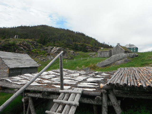
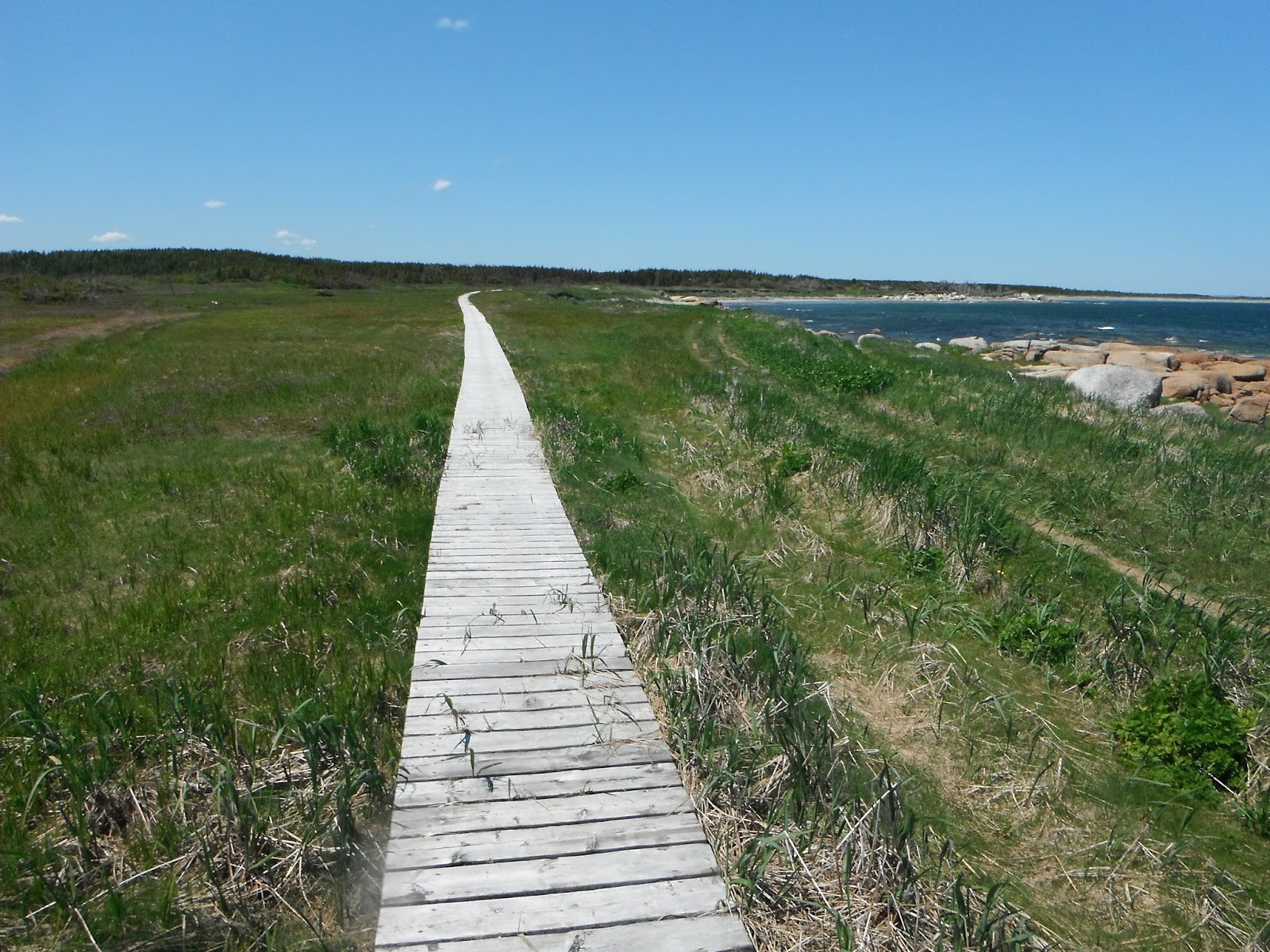
 |
| The Burnt Head trail is a 2.5km loop walking trail that features spectacular coastline, a sea arch and traces of previous settlements. |
 |
| Melanie strolls among the fields of long abandon villages. |
 |
| A fishing boat heading for the the Cupids fish plant. |
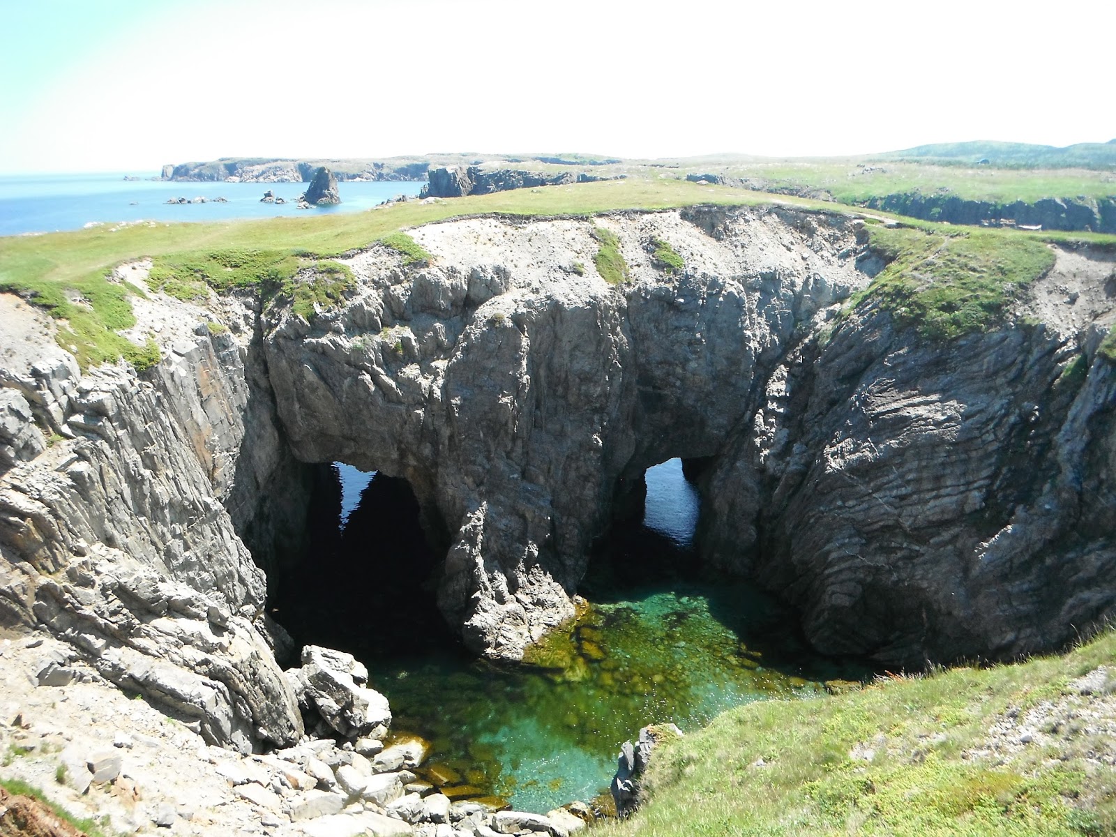
 |
| A view of the sea arch from atop.....about 15 metres down to the sea. |
 |
| A view of Spectacle Head. Our goal is to climb up to the top via the 2.5 km trail. |
 |
| The trail lacked good signage but we eventually found the correct way to the top. |
 |
| Looking out over Cupids from atop Spectacle Head. |
 |
| A view of Conception Bay. |
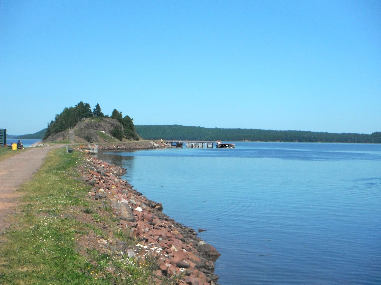
Brigus
Brigus is a picture postcard village, reminiscent of the quaintness often found in European villages.
In Brigus – just 1 hour outside of the capital city of St. John's – history thrives. The town's well-kept old-style architecture, rustic stone walls, lush green gardens and winding narrow lanes are reflective of its English, Irish and Welsh heritage.


 |
| Hawthorne Cottage National Historic Site, the former home of Captain Bob Bartlett who was born and raised here. He was hailed as the greatest ice navigator of the 20th century conducting many famous and dangerous exploratory Artic expeditions, including Peary's 1908 North Pole quest. |
 |
| A view of Brigus from the town beach. |
 |
| Quaint! Very quaint! |
 |
| Several streams run through Brigus and they are all trimmed with rock walls. |
 |
| Part of the Catholic influence.....a nunnery! |
 |
| Another walled stream! |
 |
| This Anglican church sits atop a hill over-looking the town and harbour! |
 |
| Looking out from Brigus at Conception Bay. |
 |
| The fishermen of Brigus had a tunnel cut into the rock which gave them access to prime mooring space for their fishing boats. |
 |
| At the end of the tunnel a deep water channel where boats could moor right along side the tunnel. |
 |
| This home owner could walk out on his deck and toss a fishing hook over the side. |
 |
| Yet another beautiful stream running through town. |
 |
| Many of the homes in this town remind me of English country village homes. Any sheep anywhere? |
 |
| When you walk through this town it is like stepping back in time. |
 |
| At one point in time, Capt. Bob Bartlett brought back many different animals from the Arctic destined for the zoos of the USA. When he stopped here in Brigus, these animals were brought to shore, to allow them to stretch their legs. Imagine seeing musk oxen roaming these streets at the turn of the century! |
We decided to add a little exercise to our agenda and the next day we tackled.......
Centre Hill Trail
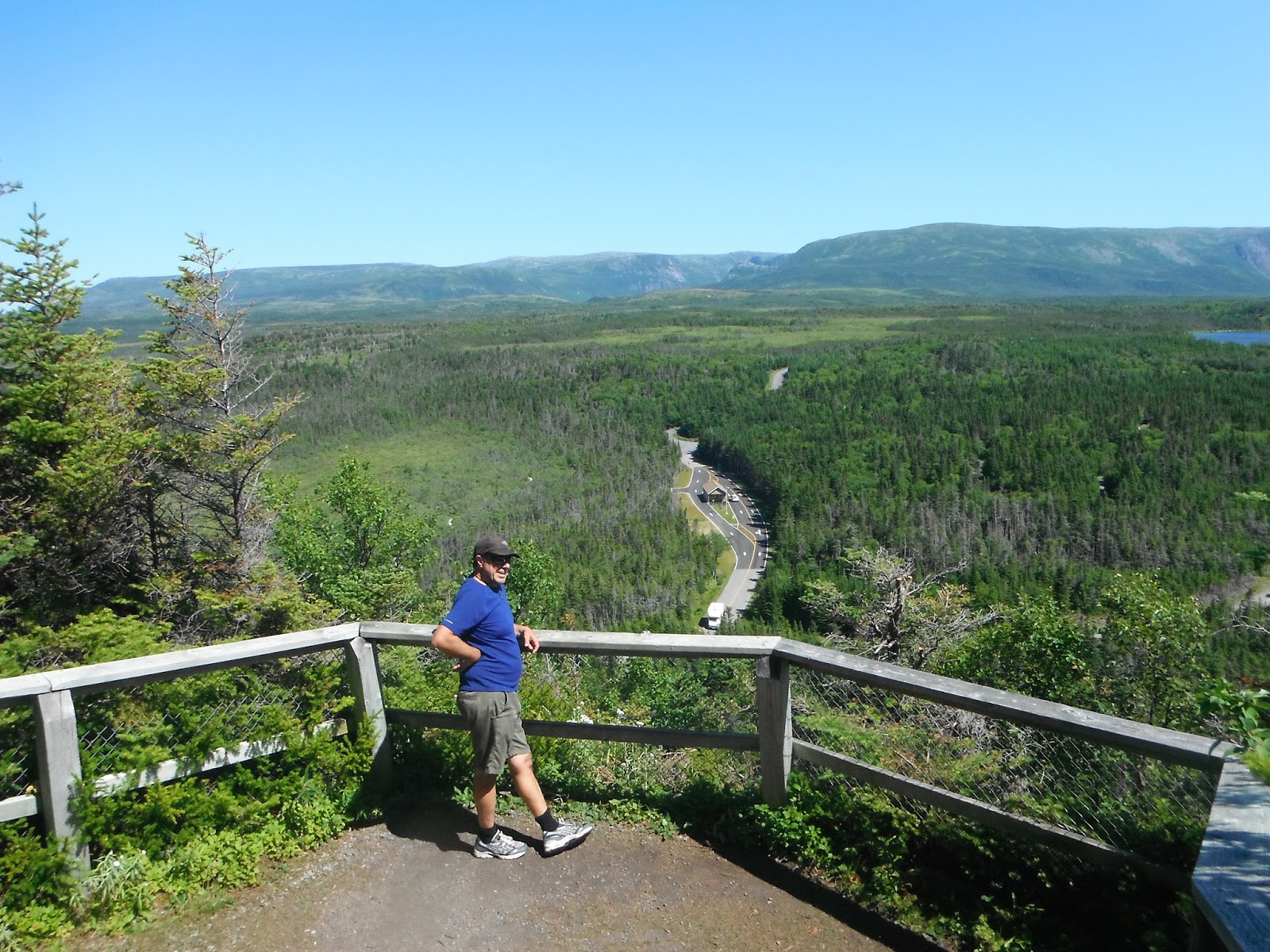
Located in Sunnyside, this trail winds pass spectacular waterfalls, marshes, trout ponds before rewarding you with a panoramic view from the peak of Centre Hill which juts 384 metres above sea level.

 |
| With an elevation of 384 metres, Centre Hill is the highest point in Eastern Newfoundland. |
 |
| After a few minutes this spectacular waterfalls comes into view. |
 |
| The trail is well maintained with a boardwalk covering most of it. |
 |
| Although it was only June 12th, the weather was unusably warm (and windy) making it perfect for hiking. |
 |
| The trail is approximately 5 kms to the top of the Hill. |
 |
| An old cookhouse is situated next to a trout pond. |
 |
| The last 400 metres of the trail involves a fairly steep climb up the hill....... |
 |
| .....but the reward is an amazing view of the surrounding area. |
 |
| Mel overlooking the Sunnyside area which was the site of a brief meeting between colonists from Cupids and a small group of Beothuk on November 7, 1612, when the two groups exchanged gifts and shared a meal. |
 |
| Overlooking Bay Bulls Arm in Southwest Trinity Bay. |
 |
| ......and now we go down! |
 |
| If you look closely you can see the boarded trail back to Sunnyside. |
On another day we hopped in the truck and spent some time exploring a portion of the Avalon Peninsula....


 |
| The three amigos with a couple of icebergs off-shore in Cavendish. |
 |
| A grey sandy beach at Salmon Cove. |
 |
| A beautiful beach at Salmon Cove but the water was only about 3C. |
 |
| The Carbonear Stone Jug restaurant where we had a bite to eat. Great food!! |
With the promise of a rainless day we decided to head for Bay Roberts to hike the...........

Shoreline Heritage Hike
The 6 km. trail is located at the tip of the Bay Roberts Peninsula and has three different spectacular views of Conception Bay. The coastal walk wanders along sheer cliffs, sweeps of beach, sheltered coves, and craggy headlands.

 |
| Mel is ready to rumble! |
 |
| "Aaaah at last, I was getting scare I may have to pee in the woods!!" |
 |
| The Shoreline Heritage Trail winds through the earliest settlement of Bay Roberts. Remains of rock-walls, foundations, root cellars, and grave sites. |
 |
| French’s Cove, an abandoned village with history going back to the late 1500s. French raids by Pierre LeMoyne d’Iberville in 1697 and Jacques Testard de Montigny in 1705 destroyed the community; however, the English settlers quickly rebuilt. Here Mel looks out from an old root cellar with a large rock wall in the background. |
 |
| "Well you got yourself in there, you'll have to get yourself out." |
 |
| This trail has several root cellars. A root cellar is a structure, usually partially underground, used for storage of vegetables, fruits, nuts, or other foods. Its name reflects the traditional focus on root crops stored. |
 |
| The path crosses between French's Cove and Juggler's Cove |
 |
| Sea gulls are responsible for the ever present sea urchin shell found far away from the actual water. The gulls pluck the urchin out of the water and drop them on the rocks which breaks the urchin and thus allowing the gull access to the tasty meat within. |
 |
| Spectacular cliffs with foamy seas below. |
 |
| The shear size of these cliffs are put into perspective as I walk out to the edge. |
 |
| The trail is well groomed by the Town of Bay Roberts!! |
 |
| Newfoundland is known as "The Rock", and for good reason, this craggy coastline continues to amaze, even after living here for the last 57 years!! |
 |
| An Inuksuk shows the way. |
 |
| At Madrock, the many moods of the true Atlantic coast are experienced, including soft mists, warm sunlight reflecting on still waters, or full-blown Atlantic storms with its massive breakers exploding against the rocks. The reason for the name “mad rock” becomes clear to anyone who experiences the surf pounding the shore |
 |
| The Three Sisters (name of the rocks) provides a pebble beach where visitors can stroll along the beach. During the capelin scull, thousands of capelin roll onto the beach. People catch the little fish with nets, dip nets, and sometimes with their bare hands! |
We head to the southern Avalon Peninsula to see the sights there.....
Placentia
Placentia possesses a lush historical and cultural tapestry stretching back to the early 16th century. Back then explorers, fishermen and settlers discovered a place rich in opportunity and ideally situated to make the most of it. French explorer Jacques Cartier arrived in 1534 and eventually the French established a colony in Placentia in 1662.
Everywhere you turn, that rich heritage surrounds you: old fortifications, archaeological digs, museums, and national historic sites are all located within a leisurely distance from one another, dotted amongst forested hills and rolling coastal inlets.

 |
| Castle Hill, the most prominent of a group of centuries old English and French fortifications that call Placentia home, with its famously commanding view of Placentia and surrounding coastline. |
 |
| A view of Freshwater village as seen from Castle Hill. |
 |
| Newfoundland's only lift bridge is found in Placentia. |
Cape St. Mary's
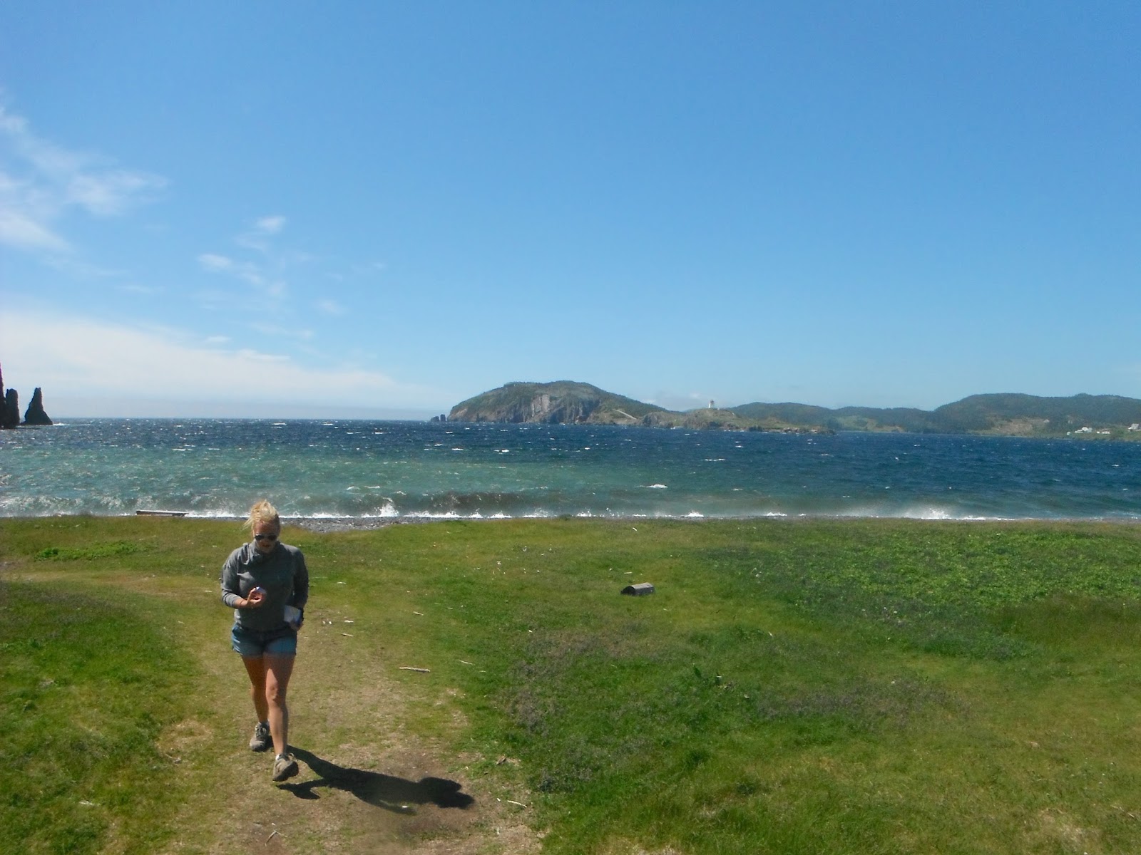
Cape St. Mary's, at the southwest tip of the Avalon Peninsula, washed on three sides by the restless Atlantic, is one of the most spectacular seabird colonies in North America. A wonderland for birdwatchers and explorers alike, you'll gaze upon thousands of northern gannets nesting atop a 200-foot-high sea stack, and smaller numbers of razorbills, common murres and black-legged kittiwakes nesting on shallow cliff ledges.

 |
| Bird Rock and the adjacent cliffs are like avian high rise apartment towers. The ledges, outcrops, overhangs and plateaus offer a variety of accommodation for a variety of seabird species. Each has found a niche that suits its particular nesting requirements. |
 |
| "Take me back to my Western boat, Let me fish off Cape St. Mary's, Where the hagdown sail and foghorns wail, With my friends the Brown's and the Cleary's, Let me fish off Cape St. Mary's."
Let Me Fish Off Cape St. Mary's
Otto Kelland
|
 |
| Nearly 10,000 nesting pairs of Common Murre nest on the ledges. |
 |
| The sea crashes around the ledges where the Common Murre will raise their chicks. |
 |
| "the birds....swirl past the cliff face like a blizzard of snow."
Roger Tory Peterson
|
 |
| The Northern Gannet with over 11,000 nesting pairs is the largest of the birds here (with a wingspan of nearly a metre). Notice the mating pair doing a little bill-rub!! |
While travelling around the province we had the opportunity to view some pretty awesome 'lawn art' or cottage art.....here are a few of those pieces of art....
 |
| Minions. |
 |
| Rock band. |
 |
| Garden gnome....or not. |
 |
| The local Army Reserve. |
 |
| What's that in your hand me ole cock? |
 |
| Chief Wood. |
 |
| Not to be outdone by anyone!! |
 |
| More than 100 years ago, Queen Victoria chose the pitcher plant to be engraved on a newly minted Newfoundland penny and in 1954 the Newfoundland government designated this interesting plant as the official flower of this province. The pitcher plant gets its nourishment from insects that are trapped and drowned in a pool of water at the base of its tubular leaves. |
One of the first things you notice when travelling around the island portion of Newfoundland is the similarities to parts of England & Ireland. In fact, scientists believe that millions of years ago, Newfoundland, England & Ireland were joined.

Joined or not, between the 17th and 19th centuries, many English & Irish immigrated to Newfoundland, bringing their distinct traditions, music, languages and culture. For instance, our connection with Ireland goes very deep, Newfoundland is the only place outside of Ireland that has an official Irish Gaelic place name: Talamh an Eisc, or “Place of the Fish”.
It is this 'Place of the Fish' that dictated the settlement patterns of Newfoundland. The towns and villages of today were originally established as seasonal fishing stations. The intention was that the fishermen would return to England & Ireland at the end of the fishing season. Permanent settlements were not encouraged for fear that it would negatively affect the English fish merchant’s profit back home. Over time, however, these migratory fishermen became settlers, and communities developed in coves sheltered from the open Atlantic and the English patrol ships that were sent to collect the fishermen at the end of the fishing season.
Our journey for this part will be along the craggy rolling coastline of the Bonavista Peninsula, or otherwise known as the 'Discovery Trail' after John Cabot landed here and “discovered” North America……

We head to.......
Musgravetown
......for the start of the recreational cod fishery with our good friends Terry & Pam.

 |
| I tow Terry & Pam’s boat to the town slipway and the Great Newfoundland Recreational Cod Fishery begins!! |
 |
| Under cloudy skies we round the point and head to the fishing grounds! |
 |
No cod fish today on the fishing grounds but there were ice-bergs!!
|
 |
| If we can’t catch any fish, then maybe we can catch an iceberg. |
 |
| No fish. No problem. We’ll just have a feed of the other bounties from the sea….snow crab legs and Atlantic lobster! Mel & Pam shucks crab legs while Terry’s Mom, Eva, who provided the crab-leg-shucking-instructions, looks on. |
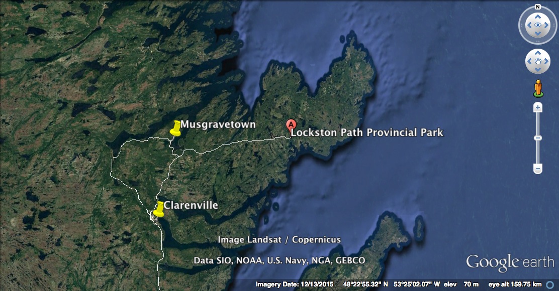
Clarenville
Clarenville, a town that initially got its start from harvesting of lumber for boat building, but because of its location quickly grew into a service centre for the Bonavista Peninsula…..

 |
| Clarenville’s 'Canada 150th' celebrations included a “Kitchen Party”, complete with a pig roast. |
 |
| “Yes by’e! Now does dat not look some darn good!!! Good nuff to eat I say” |
 |
| A dance followed the feed and the real partying began! Here we are with party-people Terry and Pam! |
 |
| They even had Mummer’s! Mummers are a Christmas time tradition only practised in Newfoundland & in isolated patches of Ireland. Also known as janneying, it typically involves a group of family and friends who dress in disguise and visit homes within their community during the 12 days of Christmas looking for a swallie of booze! |
On another day we drove to....
Random Island is Newfoundland & Labrador’s 2nd largest island with a similar shape to Canada’s other island province of Prince Edward Island. Originally settled in the 1700’s, Random Island is linked to the mainland by the Hefferton Causeway and supports a fishing industry in the largest community of Hickman’s Harbour. We went there to visit my brother, Derek, at his summer cabin in Lady Cove……..
Random Island
Random Island is Newfoundland & Labrador’s 2nd largest island with a similar shape to Canada’s other island province of Prince Edward Island. Originally settled in the 1700’s, Random Island is linked to the mainland by the Hefferton Causeway and supports a fishing industry in the largest community of Hickman’s Harbour. We went there to visit my brother, Derek, at his summer cabin in Lady Cove……..

 |
| Having a beer with my brother, Derek, on his cabin deck while watching minke whales feeding just offshore. |
 |
| A travel trailer converted to a cabin in the town of Petley. |
 |
| A slate beach in Petley. The mineral seam that produced this slate beach was mined just across the sound in Nut Cove. |
 | ||
| While we driving on the island, we came across two juvenile Red Foxes on the highway. This little fellow was bold enough to stop and have his picture taken!! |

The next day we head up the Bonavista Peninsula and park our travel trailer at.....
Lockston Path Provincial Park
 |
| Our camp site was right next to the Lockston River and this was a perfect place to have a campfire and sip on a glass of Merlot!!! |
 |
| The Fishing Stage Take-Out……another way to use a travel trailer. |
We came to the old picturesque fishing village of.....
Port Rexton
....for two reasons: (1) the food, and (2) the beer.

 |
| The village has all the right views; including the Newfoundland-red-orche-painted-traditional-fishing-stage-with-picture-perfect-background……but as I indicated we weren't here for that…... |
 |
| ……we were here (#1) for the food. In this case the award winning 4.5star Fisher’s Loft Restaurant (green-gray building in picture) that specializes in local seafood and veggies from their own gardens. "The lobster was divine darling…”. |
 |
| The view from our table! Ocean view dining at its best! |
 |
| ….and now for our other reason to visit Port Rexton - the beer: The Port Rexton Brewing Company makes 8 delicious beer varieties, not bad for a small village of 350. |
We, like so many before us, flock to the village of......
Trinity
Where to begin? This once prosperous & progressive fishing village has a new form of prosperity and progress in the form of tourism. It is set among some of the best preserved historical building in the province with amazing scenery as the backdrop. With a permanent population of less than 50 people, this village comes alive and swells in size during the summer months. There are a total of five world class restaurants, a professional acting troupe and numerous B&B’s, hotels and inns to accommodate the influx of tourist. This is a place not to be missed when touring Newfoundland & Labrador.

 |
| The best way to see the village is on foot…..so let’s begin! |
 |
| St. Paul’s Anglican Church was built in 1892 - 94 and it sits on the site of two previous churches. Its record of baptisms, marriages and burials are the oldest in Newfoundland dating from 1753. Its adjacent burial ground also has the oldest headstone in Newfoundland, that of Francis Squibb who died in 1763. |
 |
| We visited Hiscock House Provincial Historic Site: Apparently Emma Hiscock moved into the house as a bride and named it ‘Mountain Ash Villa’ for the tree she planted by the door (it still grows there now). Just a few years later Emma was left a widow with six children to support, but she persevered opening a shop, became the town post-mistress and landlady. An early example of woman entrepreneurship! |
 |
| Old homes dot the landscape everywhere here, most of them are now summer residences and they have to comply with the 50 year old Trinity Historical Society guidelines in their upkeep. |
 |
| The Rising Tide Theatre Centre is located on Green’s Point where there has been an enterprise since William Taverner first staked his plantation here in 1700. For at least 300+ years the fishing business of Newfoundland was conducted on this site. |
 |
| A photographers paradise. |
 |
| While in Trinity we ate at the Twine Loft Restaurant with our friends Terry (in picture) and Pam. "The lamb was to die for!" |
 |
| Not to be missed is the Rising Tide Theatre Company’s production of the New Founde Lande Pageant, a historical jaunt around town with jovial actors and somber scenes highlighting the highs and lows of the early years in Trinity. It was awesome!! |
 |
| With all the tourist around, you would think that this village has no other industry, but it still sustains a small inshore fishery. |
 |
| St. Paul’s Anglican Church dominates the skyline. |
 |
| Around every corner another photo opportunity. |
 |
| The Trinity Parish Hall built in 1905 still serves as a community centre for the residents. |
 |
| One would be forgiven if they thought they had woken this morning in a quaint village in jolly ole England. |
 |
| Apparently there are 50+ architecturally significant buildings in Trinity, that’s more than one per permanent resident! |
 |
| For a small outport, Trinity was blessed to have three churches: this is the Catholic Church of the Most Holy Trinity and was built in 1833, which, apparently, makes it the oldest wooden church in Newfoundland. |
 |
| And once again another Newfoundland-red-orche-painted-traditional-fishing-stage-with-picture-perfect-background…... |
 |
| ……or about this Newfoundland red-orche-painted-traditional-fishing-stage-with-picture-perfect-background…… |
 |
| ……can someone get this guy a gallon of red orche paint?? |
 |
| The sun was shining in Trinity while the rest of the bay was shrouded in thick fog…..trickery? I think not! Good luck? Definitely!!! |
One of the must do hikes on the Discovery Trail is the…..
Skerwink Trail
Every year thousands of trekkers descend on Trinity East to hike the Skerwink Trail, and there’s little wonder why. The world-renowned hiking trail, once named among the top 35 walks in North America & Europe by Travel and Leisure Magazine, features towering cliff top views, magnificent sea stacks and beautiful beaches.

 |
| A view of the ‘Flat Fish’ sea stack (so named because of its resemblance to a flounder or flat-fish) and the ‘Music Box’ sea stack (so named because of the music created when the wind blows around them). |
 |
| This 5.3km coastal loop attracts, on average, 26,000 people per year! That probably makes it the #1 hiked trail in Newfoundland?!?! |
 |
| The 'Hike Discovery’ Organization is the result of seven communities coming together in 2015 with a common goal of maintaining & promoting seven existing hiking trails, including the Skerwink. It is the most popular, and currently the most difficult rated, but we didn’t find it to bad at all. |
 |
| This trail crams a lot of sites into its 5.3kms, including icebergs!! |
 |
| “Going my way?” Silly question since there’s only one way to go,which of course is through the rock opening. |
 |
| The trail is very well maintained with steps and boardwalk when needed....and they are needed. |
 |
| The Lard Nard Rocks……gotta love how Newfoundlanders name things! |
 |
| A little perspective on the shear size of these sea cliffs. Some wicked! |
 |
| Although we didn’t see any whales while we were hiking the trail, apparently this headland is the perfect spot to view them.....if there were any to view, of course. |
 |
| A view from the trail of Trinity across the bay with the Forte Point lighthouse in the foreground. |
 |
| It wasn’t all coastal hiking, there was a couple of inland jaunts as well. |
 |
| A view of Sam White’s Cove, named after a merchant who established a lucrative fishing business here in 1699. |
 |
| Sam White’s Cove is also believed to have been occupied by French troops, due to the presence of trenches and the unearthing of a cannon ball by a local resident who was tilling the ground for a potato patch. |
 |
| Another impressive sea stack in the distance. |
 |
| Great big sea hove in. |
 |
| Of all the trails we’ve been on, we would give this one a 10 out of 10. |
We decided to go Hollywood and visit a film set for the international TV mini-series…..
Random Passage
New Bonaventure boasts the Random Passage Film Site based on Bernice Morgan's book of the same name. The site is now a tourist attraction for visitors to learn what life was like on these shores in the early 1800s.

 |
| Welcome! |
 |
| This site was constructed in 2000 and no detail was spared in reproducing the 19th century village in outport Newfoundland…..including the fake church on the hill…... |
 |
| ……with the fake grave yard and fake headstones. |
 |
| I personally never saw the mini-series but I did read the books. This was the Andrew's house, obviously he wasn’t as well off as some. |
 |
| Mel checking out the veggie garden. In the background, on a hill, is a green house which was the rich fish merchant’s home. |
 |
| Inside the rich fish merchant’s fake house with its fake fireplace. |
 |
| Inside the fake house of one of the poorer residents in Random Passage. |
 |
| Can’t have a fake fishing village without the fake fishing stage….which looks remarkably similar to the stages still used throughout the province by fishers now. |
 |
| Of course salt fish was king in the day, so Random Passage had its own fish flake with real fake fish drying. Very convincing. |
 |
| Fake. |
We headed further east along the Discovery Trail to the town of…..
Port Union
As the name suggests, Port Union is a union-built town, the only one of its kind in North America. In 1916 Sir William F. Coaker, a reformer and union organizer, purchased an unoccupied piece of land and formed the town. The harbour was ice free for 10 months a year and could accommodate 100+ fishing vessels. Coaker considered it an ideal place to establish a commercial headquarters for the Fisherman’s Protective Union and Trading Company. By 1919 the town had grown to include salt fish processing store, a department store equipped with electric elevators, a seal oil plant, a machine shop, a forge, storage sheds, a shipyard, a hotel, a bakery, a soft drink manufacturing plant, and a theatre. Unfortunately, by 1960 the FPU ceased to exist and the town fell disuse and deteriorated.

 |
| Main Street in Port Union with the Fisherman’s Union Trading Company (FUTC) factory on the left and the residences of the union managers on the right. The town holds the distinction of being both a National Historic District and a Provincial Heritage District, unfortunately neither government is dishing much money for the upkeep of this place. |
 |
| One of the FUTC buildings looking rather out of place in a rural Newfoundland outport fishing village. This is the only building left from the FPU days that is still in use. |
 |
| The FPTC factory was home to the Fisherman’s Advocate newspaper and printing press. During its peak in 1931, the Fisherman’s Advocate had a daily circulation of 11,000. |
 |
| The factory electrically operated machine shop. Hydro-electric power came early to Port Union (1918), it was only the 4th hydro plant in Newfoundland it was located near the harbour at the mouth of the Catalina River. The plant eventually supplied the entire Bonavista Peninsula as far south as Clarenville. |
 |
| The FPU owned and supplied everything including the homes of the workers, managers and even the founder, Sir William F. Coaker’s home, known as the Bungalow. |
 |
| The homes of the workers were not so swanky as that of the union managers. |
Just up from the old town of Port Union is the entrance to one of 'Hike Discovery’s’ seven trails, the....
Murphy’s Cove & Lodge Pond Trail
This moderate, 7.7km coastal loop features several headlands with magnificent ocean views, including the Green Island Lighthouse.

 |
| Fossils have been discovered on this portion of the trail on these sloping slate rock outcrops. |
 |
| Looking for fossils......never found any. |
 |
| The trail meanders along the cost past an area referred to as Johnny Houses Garden. |
 |
| Mel about to enter a tuckamore forest. |
 |
| The Grand Illusion.....look very close. |
 |
| Green Island lies just offshore. |
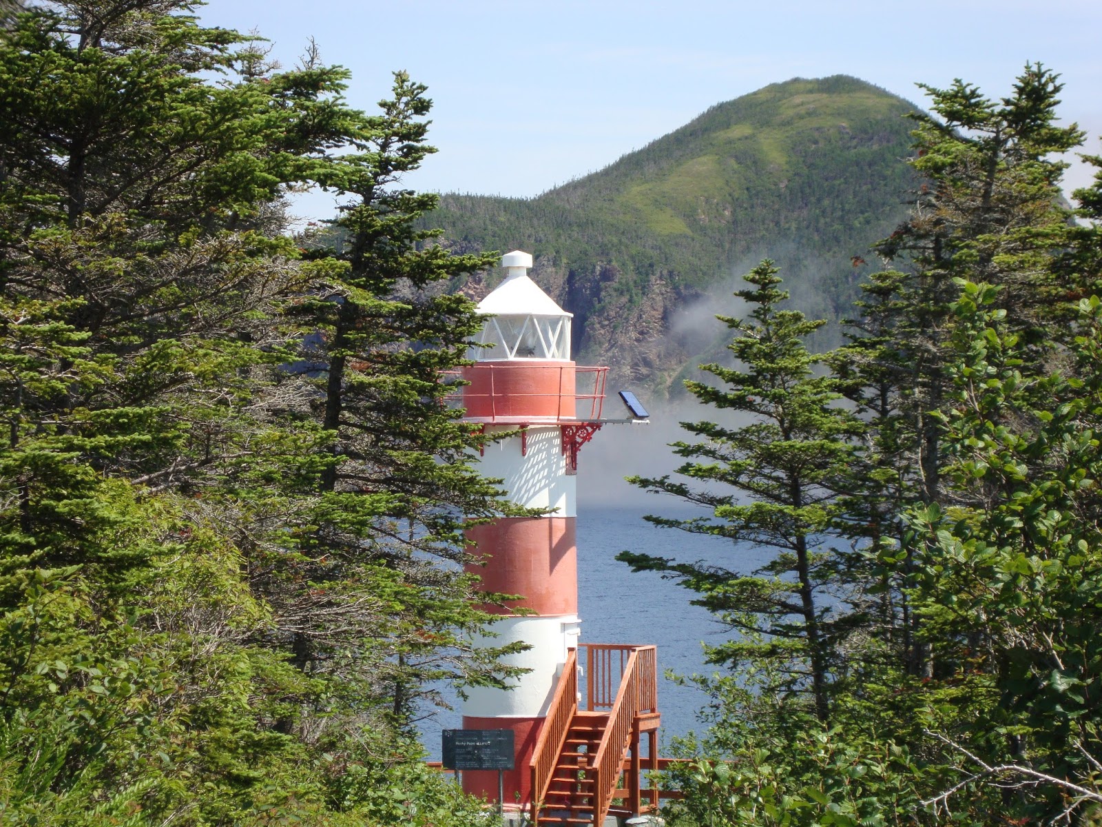
 |
| The Green Island Lighthouse was built in 1857 and is one of the few remaining manned lighthouses in Newfoundland. |
Our next stop is the town of......
Elliston
Originally known as Bird Island Cove, Elliston is also the Root Cellar Capital of the world and has claimed that title from the 135 root cellars that exist in the community. Elliston is also the home of the world's most accessible Atlantic Puffin breeding site.

 |
| Elliston is home to the Sealing Disaster memorial. The 1914 sealing disaster claimed the lives of 78 men stranded on the ice during a vicious winter blizzard. This statute depicts 16 year old Albert Crewe in his father's arms where they both perished from the elements. |
 |
| Like so many communities along the Discovery Trail, the photo opportunities are endless. |
 |
| Like all the communities along this peninsula, there is still a healthy inshore fishery. |
 |
| Some of these root cellars are over 200 years old and many are still in use today. |
 |
| Without a doubt there were a lot of root cellars around. These man-made, frost free, food preservers recall the ingenuity of the pioneers. |
 |
| A double decker root cellar. |
 |
| Mel checking out the puffins. |
 |
| An old abandoned house near the puffin breeding site of Bird Island. |
 |
| The trail to Bird Island. |
 |
| Looking back at the well used trail to Bird Island. |
 |
| The puffins nest on the islands just offshore by burrowing holes in the meagre topsoil. |
 |
| There are three different types of puffin, but only the Atlantic Puffin is found here with the other two species found in the North Pacific. |
Our last stop is at the tip of the peninsula and the town of.......
Bonavista
When Italian explorer Giovanni Caboto (or John Cabot as he is locally known) first discovered North America in 1497, his first words were “O buono vista!”. When translated into English, this phrase means, “Oh happy sight!”, which is certainly fitting for what would become the town of Bonavista, the historic site of Cabot's landing.

 |
| Hiking out to Cape Bonavista. |
 |
| Some of the sights on the Cape. |
 |
| Only in Newfoundland moment: No trees to put up a clothesline, no problem....hang your clean underwear on an available "Do Not Litter" sign to dry!! |
 |
| "Bonavista's finest!"....or not! |
 |
| The Bonavista Lighthouse first lit in 1843 when the original lamp used seal oil. |
 |
| We scrambled around the craggy shoreline looking for the perfect picture! |
 |
| One of those perfect pictures! |
 |
| On the way to The Dungeon Provincial Park. |
 |
| The shoreline at The Dungeon Provincial Park. |
 |
| The Dungeon, a massive collapsed sea cave formed by relentless wave action of the North Atlantic. |
 |
| The Mockbeggar Plantation: This original fish store (a place for storing salt fish) was built in 1733 and that makes it the oldest wooden structure in Newfoundland! |
 |
| This canal opened up into a saltwater pond, right in the middle of Bonavista, making it the perfect place for punts to get out of the North Atlantic swell. |
 |
| Bonavista became one of the most important towns in Newfoundland due to its proximity to the rich fishing and sealing grounds to the north of the peninsula. The Spanish, Portuguese, French and English fished off Cape Bonavista during the 16th century |
 |
| Seagull cooperated for this picture!! |
 |
| Bonavista was a major commercial centre and the evidence for this is preserved at the Ryan Premises, a National Historic Site maintained by Parks Canada. It is a restored example of a large fish merchant's operation. |
 |
| Another view of the Ryan Premises. |
 |
| The Bonavista courthouse. |
After an awesome visit to the Bonavista Peninsula we head for the heart of Newfoundland……
The Central Region
With two sea coasts and the forest in between, the central region contains some of the best outdoor experiences in the province. It’s the centre of Iceberg Alley, a stretch of coastline where ancient towers of ice majestically float down from Greenland. It’s stuffed with bays, coves, and lively communities, fascinating histories and beautiful beaches, and some of the best salmon rivers on the planet.

Our first stop is the town of.....
Gambo
Gambo is best known as the birth place of Joey Smallwood. He successfully led the country of Newfoundland into a union with the Dominion of Canada, and became the first Premier of the province in 1949. There are several commemorative pieces that recall his life and work around town, however we weren’t here for that, rather we were here to park our trailer at the David Smallwood Park.

 |
| The David Smallwood Park was nice, but it was mosquito season and the park offered no protection from the blood thirsty hordes except for a breeze from the town's hiking trail that ran along the salmon river, Middle Brook River. |
 |
| Salmon fishing, that sport that calls on every fibre of patience that one can humanly muster. I expect the only battle these fishermen were experiencing were with the mosquitoes! |
 |
| THE SELFIE MIESTERS! |
Our real reason to be in Gambo was to park our trailer and use it for easy access to……
Terra Nova National Park
The most easterly national park in North America, Terra Nova boasts 400 square kilometres of natural beauty with landscapes varying from the rugged cliffs and sheltered inlets on the coast, to the rolling forested hills, bogs, and ponds of the inland. With nine hiking trails that stretch out more than 75 kilometres, we were here for the hiking!
Our first hike was the…..
Coastal Trail
The most popular trail in the park, this 9.5km return trail traces the coast of inner Newman Sound.

 |
| The start of the trail at the Visitor’s Centre in Newman Sound. |
 |
| The trail is easy and hugs Newman Sound. |
 |
| From 1970 to 1974 my family lived in Clarenville, about 65kms from here, and during the summer my parents would permanently park their trailer in Newman Sound Campground. As kids, we practically grew up in this park, and I remember, as kids, riding our bicycles on this trail. |
 |
| At times the trail skirts along the gravel beaches that line this part of Newman Sound. |
 |
| “Mel look at dat dere.” |
 |
| The trail ends at the Newman Sound Day Use area, at which point one turns around and goes back from whence one came. |
The next day we go back to Terra Nova to do the…..
This trail combines two popular trails to make a moderate 8km loop which takes in an abandoned community at Buckley’s Cove and Blue Hill Pond.

 |
| This trail also skirts Newman Sound but in the opposite direction as the Coastal Trail. |
 |
| You hike through black spruce carpeted by moss. |
 |
| Looking back at Newman Sound. |
 |
| “Hey Mel, wait up…..what’s the hurry?” |
 |
| The trail looped itself through several ecosystems including area damaged by Hurricane Igor a few years ago. |
 |
| Buckley’s Cove. From here you turn inland and head for the hills….. |
 |
| Heading for the hills. |
 |
| The beautiful Lady Slipper Orchid was in bloom….. |
 |
| …..actually the entire forest was in bloom!! |
 |
| Blue Hill Pond and me without my fishing rod. |
 |
| I feel like Dorothy on the Yellow Brick Road. |
 |
| A view of Blue Hill Pond and the upper reaches of Newman Sound. |
The next day we gave the hiking a break and instead went sea kayaking in Newman Sound and Big Brook….

 |
| We paddled down Newman Sound all the way to Big Brook and, given that it is a BIG brook, we paddle up it for a while. |
 |
| I had paddled up this brook in a canoe many years ago and wanted to retrace my steps with Melanie, only this time in a kayak. |
 |
| We went as far as we could up the brook and now we are heading back down to Newman Sound. |
 |
| The water in this part of the Sound is really shallow forcing us to manoeuvre around the sand bars. |
 |
| The temperature was around 24C and not a breeze…the perfect day on the water! Wouldn’t you agree Melanie? |
 |
| We stopped in Newman Sound Day Use area for a rest up. |
 |
| Terra Nova’s Day Use area and a selfie. |
 |
| Looking back at lower Newman Sound….great paddle!! |
We weren’t done with the hiking yet, and the next day we did a portion of the...
Outport Trail
The longest trail in the park with a total distance of 16km one way, it normally starts at Big Brook (the brook Mel & I had kayaked the day before) and continues for 16km to South Broad Cove. We cheated! We took a water taxi to South Brook Cove, with the intent of hiking as far as Mount Stamford before returning home via water taxi.

 |
| We take the water taxi from the Visitor’s Centre. |
 |
| The water taxi was $25 and took about 20 minutes to get to South Broad Cove but it knocked off about 20kms of hiking…..worth it!! |
 |
| “This is GREAT!!!!” |
 |
| Mount Stamford is that knob of rock back there. We will hike from South Broad Cove to the top and return back the same way to Minchins Cove for a total of 12km. |
 |
| South Broad Cove is an abandoned village remotely situated within the park and only accessible by foot or water. |
 |
| The water taxi dropped us off and indicated that he would return to pick us up in Minchins Cove in 3 hours. |
 |
| South Broad Cove is 16km from civilization and all that is here is a Park maintained wharf. Time to get ready for some hiking! |
 |
| The trail skirted the coastline for 2km with fabulous views of tranquil inlets. |
 |
| After 10 minutes we break out into the former old saw milling settlement of Minchins Cove. |
 |
| Not much remains of the old village except this remnant of the old saw mill. |
 | |
| We once again head inland and see evidence of turn-of-the-19th century logging by the Minchins Cove crowd. |
 |
| Our goal today, Mount Stamford, highest piece of land (197metres) in Terra Nova National Park. |
 | ||
| Although Mount Stamford isn't high, it was hot and muggy, so the hike was still taxing. |
 |
| Almost to the top. |
 |
| TADA! The view out Newman Sound and Bonavista Bay! |
While we are in Gambo we head for the Eastport Peninsula for a drive. Our first stop was in the village of……
Eastport
On the ‘Road to the Beaches’, Eastport is famed for its sandy beach.

 |
| Newfoundland’s ‘Road to the Beaches’ starts here, at the Alexander Bay causeway. |
 |
| Eastport beach on a very hot (and rare) June day. |
 |
| Mel beachcombing for the perfect shell. |
 |
| Eastport has a excellent short boardwalk over to the next beach. |
 |
| ……and now for a moment of reflection. |
We leave Eastport and continue on down the peninsula until we come to the end of the road and the village of……
Salvage
Perhaps the most photographed area on the peninsula is Salvage, pronounced with a long “a” as in “age”. This is the oldest European settlement along this part of the coast and is a classic outport with all the required sights for the photographer.

 |
| Salvage, a community at the far east of the western world. |
 |
| Let the exploring begin...... |
 |
| Red ochre and virgin white paint, two most popular colours on the coast of Newfoundland. |
 |
| As you can see from this picture, Salvage is still very much a fishing village, both inshore & offshore. |
 |
| “Wait a minute, there’s a house over there painted blue…..no no no no, that will just not do.” |
 |
| The classic-stand-next-to-the-stinky-crab-pots-picture. |
 |
| We climbed up to the municipality-condemned lookout for a view. |
 |
| There is some sort of history with these two houses, but I forget what it is. |
 |
| Lobster fisher coming back from checking the pots. |
We leave Gambo behind and head for Newfoundland’s ‘Road to the Shore’ with our first stop being in…….
New-Wes-Valley
The amalgamation of several towns within this area resulted in New-Wes-Valley. This area has a unique history. A small peninsula juts out into the Atlantic, bringing the resources of the sea just a bit closer than elsewhere along the coast. On top of that, the waters here are a bit warmer, which means the area has milder winters. This is what first attracted Aboriginals to Cape Freels thousands of years ago, however today it is Newtown that is attracting us to this area.

 |
| Newtown - called the Venice of Newfoundland because it is built on a series of tiny islands. |
 |
| Every house has sea front property, regardless where they are located in Newtown. |
 |
| The Anglican Church looks like a large iceberg! |
 |
| Because I just like this picture…. |
 |
| ….and this one as well….. |
 |
| ….and I also like this picture…. |
 |
| …..OK what can I say.!!! |
 |
| Mel chilling out at the Olde Shoppe Cafe drinking an ice cold Quidi Vidi Iceberg beer. Yummy!! |
 |
| The Barbour Living Heritage Village was built by fish merchant, Alphaeus Barbour, in the late 1800’s. |
 |
| Alpheaus Barbour’s 1904 Queen Anne-style mansion. |
 |
| Indoor plumbing came early for the Barbour’s. |
 |
| Two sons who live with you but you know they may not always want to live in harmony together. What to do about the house that they live in? Build two sets of stairs to the upper floors, so the sons could split the house down the middle if need be! |
 |
| Another look at the Barbour Heritage Village. |
We continue on up the road to the village of.....
Lumsden
Lumsden, originally called Cat Harbour, was visited as early as the 18th century by French fishermen because of its good inshore fishing grounds. On an early French map, Lumsden was named Hav Dechire, or Wrecking Harbour. It was a part of the French Shore until 1783. The town motto states: Small town Big beach.

 |
| BIG beach. |
 |
| Really BIG beach. |
 |
| Oddly, just a kilometre away the sand disappears and is replaced by a few rocks! |
We set up camp in the Banting Memorial Municipal Park within the town of….
Musgrave Harbour
Outside of having a 16km beach, Musgrave Harbour's greatest claim to fame is Sir Frederick Banting, co-founder of insulin, died in a plane crash near the town during WWII.

 |
| Banting Memorial Municipal Park had a spectacular beach behind it and a shallow pond in front of it. A great park. |
 |
| We walk down to the beach on this bright sunny, albeit a tad breezy, day. |
 |
| Because the winds were northeasterly a fair amount of slob-ice had washed up on the beach. Slob-ice is the very small pieces of ice that breaks off the many ice-bergs floating by in Ice Berg Alley. |
 |
| We came across a municipal hiking trail that hugged the beach for the 6km to Musgrave Harbour. Unfortunately we knew not of this beach-hugging-municipal trail, so we were not prepared for such a long hike today. We’ll be back. |
 |
| I give you the marvelous Mr. Mistoffeless. |
 |
| The wind had a real chill to it and it caused a foggy mist to rise from the warm water shallow ponds. |
 |
| An optical illusion….the foggy mist rising from the pond gives the illusion that the Hudson Bomber (a replica in the Park of Banting’s ill-fated plane) was flying. |
 |
| There’s an old saying: “Red sky at night, a sailor’s delight. Red sky in the morning, a sailor’s warning.” From the redness of this night sky, we were in for some day tomorrow!! |
 |
| As the old saying said, we woke up to hot sunny summer weather, rare for early June, but nevertheless here it was! Today we would walk the 6km to and back from Musgrave Harbour. |
 |
| We pick up where we left off the day before. |
 |
| Black crow meets white sea gull…….omen? Maybe. |
 |
| We would find out later that this trail had fallen into disuse however some of the old boardwalk remained, so when we could we walked on this easier surface….. |
 |
| …..and when the boardwalk disappeared we walked the beach. |
 |
| This is lobster season in this part of the world and the lobster fishers were busy checking their pots. |
 |
| Now and days, more ATV drivers use the trail than hikers. |
 |
| The trail ends at the closed FPU Museum. |
Our next journey is to grab a ferry and head for…….
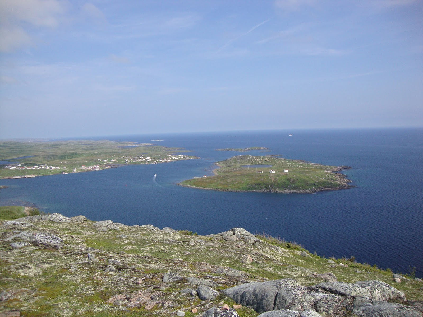
Fogo Island
Fogo Island, the largest of Newfoundland & Labrador’s islands, is brimming with amazing seaside vistas, fascinating geography and unique cultural history. First settled in the 1800’s, the residents of the eleven communities on the island made their living from the sea, but today tourism is ranking a close second, as an economic driver.

 |
| We board the MV Veteran for the ferry ride to both the Change Islands & Fogo Island. |
 |
| Under hot and sunny skies we set sail for Iceberg Alley’s epicentre. |
 |
| Our visit to the Change Islands was short as only five vehicles got on with the same amount getting off. |
 |
| We had left the ferry and driven no more than 1 minute when the photo-ops began…… |
 |
| Ice growlers and pan-ice were everywhere. |
 |
| As kids, when the ice-pans washed ashore, we would clamour on top and jump from one to the other and use them as rafts. |
 |
| This fisher added a slight twist to his fishing stage door! I like it! |
 |
| Brimstone Head. This large chunk of rock is known for its unusual designation within the world of unusual designations: it is designated by the World Flat Earth Society as one of the four corners of the world. The other three corners are in Papua New Guinea, the Burmuda Triangle and the island of Horta in Greece. Who knew? |
 |
| The parking lot was far enough for some tourist to go, after all when icebergs are this close, why climb all the way up there? |
 |
| ….but alas we are climbers, so it is up we go! |
 |
| Just a few more steps to Earth's fourth corner. |
 |
| Iceberg Alley from Earth’s fourth corner! |
Video of Ice-Berg Alley.
 |
| A view of the town of Fogo from Brimstone Head. |
 |
| Architectural giants in most Newfoundland outport communities are the churches and Fogo is no different. |
 |
| Fogo Island Inn, a sleek Nordic-style hotel perched on stilts at the edge of the ocean. We didn’t stay this time because I didn’t have the correct change….$1919 per night (meals included). |
 |
| The Inn’s restaurant, one of Enroute magazine’s best in Canada, boasts gourmet cuisine infused with bounty of the island and their own gardens. |
 |
| Iceberg floating right next to the Fogo Island Inn…..million dollar view…… |
 |
| …..million dollar view increased tenfold when the iceberg decided to self destruct…. |
 |
| ….me thinks the Fogo Island Inn orchestrates these iceberg break-ups for the highfalutin guests….. |
 |
| …..me also thinks the Inn builds and paints these fishing stages for same highfalutin guest to take pictures. |
 |
"Hip-yer-partner Sally Thibault
Hip-yer-partner Sally Brown
Fogo, Twillingate, Morton's Harbour
All around the circle."
Traditional Newfoundland Song:
I'se the B'y
|
We head for Newfoundland’s ‘Road to the Isles’ islands of......
New World and Twillingate
Given that the largest community of Twillingate is on the small island of Twillingate and given that the two islands are so close together (only a bridge separates them) most refer to the place simply as Twillingate. Rated the #1 tourist destination on a per capital basis in Canada, tourist flock to Twillingate which embodies everything so many Newfoundland & Labrador outports are famous for: stunningly rugged coastline, historical significance, picture perfect scenery and real friendly people.


 |
| Immediately upon crossing the causeway to Twillingate is the 'Prime Berth - Twillingate Fishing & Heritage Centre', a historic fishing premise which has the distinction of being ranked #8 museum in Canada. |
 |
| The sign on the door to the family-run museum states: “We live next to the gift store - knock on our back door if we are not in the store.” Gotta love Newfoundland! |
 |
| Without government funding, the owner salvaged a dead whale, cleaned the bones, reconstructed the bones, and mounted the bones at his museum. |
 |
| “…..and now, I’m please to announce, the new 2017 Miss Crab Cakes crown goes to Melanie!!!” |
 |
| Heading for Long Point along the rugged North Atlantic coastline. |
 |
| The end of Long Point, aptly named Nanny’s Hole……nice. |
 |
| Long Point Lighthouse, built in 1876, stands high on a cliff above Nanny’s Hole. |
 |
| So we’re driving along admiring the sights when I see this perfect picture, so I jump out of the truck and take a snap…….. |
 |
| …..I turn and there’s another perfect picture, so I take another snap. I start to head back to the truck when this elderly man approaches us. He ask if we want to look inside his fishing stage, the stage I just took a picture of…... |
 |
| ….so we say yes and TADA……here I am with Melvin, the retired fisherman, inside his fishing stage looking at his ball-point pen collection…… |
 |
| …….Melanie & Melvin in front of his stage. |
 |
| We booked a hotel and plan on staying the night, mainly because we wanted to go to the Twillingate NWI Dinner Theatre at the building in the background. It was awesome! |
 |
| Later that night, back at our hotel bar, one of the performers from the Dinner Theatre (guy sitting) grabbed his guitar and started a jam with the that night’s bar entertainer. More awesome! |
 |
| "Hip-yer-partner Sally Thibault, Hip-yer-partner Sally Brown, Fogo, Twillingate, Morton's Harbour, All around the circle."
Traditional Newfoundland Song
I'se the B'y
|
We leave Twillingate, but not New World Island as we next head for......
Morton's Harbour
Immortalized in the traditional Newfoundland song I'se the B'y, Morton's Harbour didn't capitalize on the tourism the same as Fogo & Twillingate, instead it seems like a town that time forgot.

 |
| There are no services (i.e. restaurants) in Morton's Harbour for tourist, in fact there isn't much in Morton's Harbour but great photo-opts. |
 |
| Many of the fishing stages have fallen into disrepair. Someone get this guy some red ochre paint! |
 |
| There was one attraction drawing tourist......this iceberg had grounded itself conveniently right next to the government wharf and it was massive! |
 |
| Like clouds, a person can sometimes see shapes in an iceberg - I see a bird sitting on its nest. What do you see? |
We pack up the trailer and leave Musgrave Harbour for the town of Grand Falls Windosr…….
Grand Falls Windsor
Grand Falls Windsor sits on one of the best salmon rivers in the world - the Exploits River. This river has spawned - pun intended - a raft of attractions and we are here for these. I was born in this town, back when it was a pulp and paper mill-town, fast forward 57 years and the mill no longer exist and Grand Falls Windsor is now a service town.

 |
| Grand Falls - this was the end of the line for spawning salmon as getting pass this barrier was impossible for them. The old pulp an paper mill damn the falls off years ago, and while the mill has gone, the dam remains. |
 |
| We visit the Salmonid Interpretation Centre located at the Grand Falls Fishway where we see a few fish jumping the steps to this 500-foot long fishway. |
 |
| Within the Salmonid Interpretation Centre are underwater viewing windows where we come face-to-face with the “King of the River”. |
 |
| Supper!! |
The next day we decide to go whitewater rafting on the Exploits River......


 |
| Time to get wet, and the best way to do that is whitewater raft the Exploits River. The Exploits is Newfoundland’s longest river at 246 kilometres. |
 |
| With the temperature soaring to 31C, this was THE perfect day for some wet fun! |
 |
| Swim time! |
 |
| As whitewater rafting goes, this river is very tame, but it still has it moments. |
 |
| The Badger chute. After riding over it on raft, some of us opted to jump from a rock into the eggbeater broiling waters! Some fun! |
 |
| We pull out for lunch and some surfing. |
 |
| Mel sizing up “Rose’s Roost”, the favourite spot to hang out and ‘roost and surf’ in the currents…… |
 |
| …..Mel, moi and guide surf “Rose’s Roost”. Surfing can happen where upstream and downstream currents meet and are fighting each other. There is a sweet spot of sorts in the middle where you can roost….. |
 |
| …..this is the sweet spot!! |
On another glorious day we drive to the town of…..
Botwood
In the 1930’s Botwood was a refuelling stop for the first transatlantic air passenger service. Back then it was float planes that ruled and Botwood had the perfect port that never froze. My reason for coming here is because from 1967 - 70 our family was stationed in Botwood, so I came back for a look at the old homestead!

 |
| The plane that put Botwood on the map in the dirty 30's. Imagine crossing the Atlantic in one of these!! |
 |
| This linked island was used for many purposes over the years, back in the 40’s it was an American munitions storage area - there are 4 or 5 cement bunkers on the island. When I was growing up close to here, we would play Cowboys & Indians and “War” on this island..... |
 |
| ….now the island is a walking trail and once again I was transferred back to my childhood, albeit if only a game of Cowboys & Indians. |
 |
| Flipper's Last Stop. We were looking for a feed of seal meat but they didn't have any......damn the luck. |
We got it in minds to head for the island village of Gaultois on the Connaigre Peninsula. Our intent was to park our truck and take the ferry to Gaultois, stay at the only hotel around and pan out from there seeing some of the more remote villages on Newfoundland’s south coast. Unfortunately, when we arrived in Hermitage we discovered the ferry wasn’t running due to being on dry dock for a retrofit. With no means to get to Gaultois, we had no choice but to retrace our steps back to Grand Falls Windsor (about a 3 hour drive). Before heading back we decided to go to……..
Harbour Breton
The historic fishing town of Hr. Breton is one of the oldest and largest communities on the south coast. First settled by French fishermen, and later by the English, its commerce was dominated for decades by the Newman family, famous for its Newman’s Port Wine, which is still available today. This whole coastal area is heavily indented with spectacular fjords.

 |
| Harbour Breton’s mainstay since day one is the traditional fishery. |
 |
| A thick receding fog created a surreal landscape. |
 |
| The Rocky Point Lighthouse is a short scenic walk with Harbour Breton Bay as the backdrop. |
 |
| Sunny Cottage, a large Queen Anne house built in 1907 by a local merchant. |
After spending a full day of driving to and from the Connaigre Peninsula we needed to get some exercise, so we head for the village of…..
King’s Point
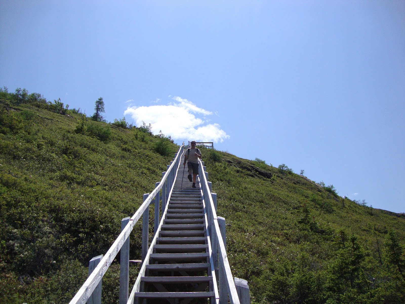
Located in scenic Green Bay, King’s Point got its start providing lumber to French fishermen and navy vessels occupying the “French Shore”. In 1860 the first European settler, James King, established a fishing premises on the point and thus came the name King’s Point. All trivia now, what really counts is that King’s Point is the location of the Alexander Murray Hiking Trail.

 |
| This 8km trail takes you 335 metres in elevation to a breathtaking view of Green Bay and the Gaff Topsails, but first you have to negotiate the 2200 steps. |
 |
| An offshoot to the main trail is 220 steps down to the bottom of a 600-foot gorge. |
 |
| The 220 steps down were worth it. A waterfalls and swimming hole (too cold for us) and the place all to ourselves. |
 |
| This is all well and good, but we now have 220 additional steps to climb up to the main trail which will then include hundreds of more steps…. |
 |
| The view from halfway up. |
 |
| Mel taking a breather with the gorge in the background. |
 |
| Nine hundred and ninety-one, Nine hundred and ninety-two,….Mel, how much longer??? |
 |
| A selfie miester snap from the top! |
 |
| A view from the top of beautiful Green Bay. |
 |
| And now we go down! |
 |
| One of the three waterfalls on the trail. |
 |
| Anyone who thinks going down steps is easier hasn’t walked down 1100 of them…..trust me it is not easy on the knees. |
 |
| After the hike we went ot the Dr. Jon Lien Whale Pavilion where a 52 foot humpback whale skeleton is on display. |
We continue our trip of Newfoundland & Labrador by heading for Newfoundland’s……..
Stretching 363 kilometres, the Great Northern Peninsula has it all, with ancient mountains, fjords, and thousands of miles of coastline, this wild and rugged region sports abundant breathing room and diverse natural heritage, not to mention a pair of UNESCO World Heritage Sites (there are only four in Newfoundland). The first, spanning 1,805 sq.kms., is Gros Morne National Park, the other, L’Anse aux Meadows National Historic Site, is the first European settlement in the ‘New World’.

With great anticipation we head for the midway point of the GNP and park our trailer at the RV park in………
Deriving its name from the river that flows from a number of ponds in the area extending from the foot of the Long Range mountains to the ocean, River of Ponds is well known for its phenomenon salmon fishing. I have come here on a couple of occasions with my good friend Stewart to go salmon fishing (with no luck whatsoever).


Known as the Big Land, Labrador is one of the last untamed, unspoiled places left on earth. Stretching from the Strait of Bell Isle in the south to Cape Chidley in the far north, Labrador is HUGE covering 71% of the province’s land mass but it has only 8% of the population - it is one of only a few places left where you can have this much space to yourself!


We take a walk along the 'Boney Shore Trail'....

L’Anse aux Meadows


This time of year people flock to the village of .....


Great Northern Peninsula
Stretching 363 kilometres, the Great Northern Peninsula has it all, with ancient mountains, fjords, and thousands of miles of coastline, this wild and rugged region sports abundant breathing room and diverse natural heritage, not to mention a pair of UNESCO World Heritage Sites (there are only four in Newfoundland). The first, spanning 1,805 sq.kms., is Gros Morne National Park, the other, L’Anse aux Meadows National Historic Site, is the first European settlement in the ‘New World’.

With great anticipation we head for the midway point of the GNP and park our trailer at the RV park in………
River of Ponds
Deriving its name from the river that flows from a number of ponds in the area extending from the foot of the Long Range mountains to the ocean, River of Ponds is well known for its phenomenon salmon fishing. I have come here on a couple of occasions with my good friend Stewart to go salmon fishing (with no luck whatsoever).

 |
| Home for the next couple of weeks! |
 |
| At some point in time the village of River of Ponds constructed a 3km trail along the river which we decided to hike. |
 |
| The trail displayed many wildflowers that we had not seen before. Anyone know what this is? |
 |
| Eventually we came to a ‘DANGER’ sign. What now? Why we just keep right on going, of course! |
 |
| And here is the reason for the danger sign……a complete washout of the trail. It's 10 metres to the river below. |
 |
| We are glad that we continued as the trail and river eventually ends at the ocean. |
 |
| Cooooool. Dolphin backbone I would guess. |
 |
| Mel pondering the age-old question: Where does all this driftwood come from? |
We head a short way up the road to the village of…..
Hawke’s Bay
Situated at the mouth of the Torrent River, Hawke’s Bay was named in 1766 by Captain James Cook to honour British Admiral Edward Hawke and his great victory over the French fleet at Quiberon Bay in 1759. We came here to walk the Torrent River Nature Park boardwalk.

 |
| At four kilometres long, this is without a doubt the longest boardwalk I’ve ever been on! |
 |
| This is considered one of the best salmon fishing rivers in Newfoundland. |
 |
| A field of wild grains grow in a river cove. |
 |
| I cannot begin to imagine the amount of money it took to construct a 4 kilometre boardwalk. |
 |
| WTF |
 |
| As kids growing up in Newfoundland, we called these berries “Crackerjacks”, whereas the actual name is 'bunch berries'. |
 |
| We cross over a bridge and continue. |
 |
| End of the line....Torrent River Falls and fish ladder |
Our next stop is the village of…….
Port au Choix
A National Historic Site, Port au Choix is a fishing community that has been providing a living for its residents for over 6,000 years. First came the Maritime Archaic Indians (there is a burial ground here), then the Groswater Palaoeskimo and the Dorset Palaoeskimo peoples, who both had a large settlements here at Phillip’s Garden so many years ago. Our intent is to hike along the ‘Coastal Trail’ to Philip’s Garden and onwards to the lighthouse.

 |
| The trail starts out fine enough, running alongside driftwood strewn beaches…. |
 |
| ….and pass modern art depicting ancient cultures. |
 |
| A Tuckamore forest, nature’s bonsai trees, are small dense trees horizontally shaped by the fierce winds that blow off the ocean. They are usually so tightly packed that you can, at times, walk on top of them. |
 |
| The limestone barrens that make up this area supports nearly 1/2 of the 300 vascular plants that are considered rare for Newfoundland….I think I see one! |
 |
| 2,000 - 4,000 years ago Dorset Palaoeskimos & Groswater Palaoeskimos walked this same coastline. |
 |
| Not long after the archaeological dig at Philip’s Garden, the first of several different limestone rock formations appeared. Such as this one. |
 |
| This formation of split limestone lasted for over a kilometre. |
 |
| The stone falls away to the sea like giant stone steps. |
 |
| We round a headland and enter Never-Never-Land. |
 |
| Same stone as the other area, but the erosion is different. Odd. |
 |
| It's like a grand cathedral..... |
 |
| …..and these silent rock formations are the parishners. |
 |
| I could scamper around on these all day…… |
 |
| …..apparently so can Melanie! |
 |
| I’ve never seen rock formations like this in Newfoundland before….who knew. |
 |
| We continue our journey along the trail and eventually walk into the third strange formation area…. |
 |
| …..limestone barrens. Same stone as the other areas, but the erosion is different. Odd again. |
 |
| No worries about getting lost. Just walk towards the light….house…..lighthouse! |
 |
| Point Riche lighthouse, the end destination of our trek. |
We board the car ferry, MV Apollo, at St. Barbe and cross the Strait of Belle Isle to the coast of……
Labrador
Known as the Big Land, Labrador is one of the last untamed, unspoiled places left on earth. Stretching from the Strait of Bell Isle in the south to Cape Chidley in the far north, Labrador is HUGE covering 71% of the province’s land mass but it has only 8% of the population - it is one of only a few places left where you can have this much space to yourself!


Our first stop in the Big Land is the super tiny village of.....
L’Anse Amour
L'Anse Amour, where you will find the oldest known burial site in North America of a young Maritime Archaic Indian who died about 7,500 years ago. We, however, were on our way to Atlantic Canada’s tallest lighthouse.
 |
| Built in 1855 of limestone quarried at nearby Fox Cove, Point Amour Lighthouse, reaches for the sky with a overall height of 125 feet to the tip. |
 |
| The climb up, with the last 10 feet via ladder. |
 |
| From here you can easily see the Great Northern Peninsula of Newfoundland across the straits. |
 |
| Looks like concrete blocks but it is actually ancient coral reefs, approximately 350 million years old (Cambrian era) and only found here and in Siberia. |
We continue up the Labrador south coast to the UNESCO and National Historic Site of…….
Red Bay
Right and Bowhead whales, once plentiful in the waters of coastal Labrador, attracted whalers from the Basque region of northeast Spain and southwest France during the 1500’s. A thriving industry based on the production of whale oil for sale in Europe developed along the Labrador coast during the mid to late 1500’s. The busiest port for this historic enterprise was the sheltered harbour of Red Bay.

 |
| A nearly complete chalupa, a boat used by the Basque whalers to hunt and kill whales, was excavated from the harbour of Red Bay and is on display at the Parks Canada Interpretation Centre. |
 |
| Red Bay was a treasure trove of photo opportunities. |
 |
| This used to be an active fishing town, but now the main employer is tourism. |
 |
| Deserted Ryan Island is still privately owned by the same family for over a couple hundred years, apparently they had a thriving fishing enterprise on the island in bygone days. |
 |
| Overturned boats and fishing sheds choked with weeds. As explained to us by a local resident, the town's population simply got old and there wasn’t anyone interested in taking up the fishing trade. |
 |
| Saddle Island, at the mouth of Red Bay harbour, are the remnants of where the Basque lived and worked more than 400 years ago. |
 |
| Saddle Island is a mere 2 minutes by water-taxi from Red Bay. |
 |
| This island is littered with reminders of its past, including the more recent ones, such as this abandoned fishing boat. |
 |
| Parks Canada now owns Saddle Island and they maintain a marked interpretive trail to various sites of whale oil rendering ovens, cooperage, living quarters and a cemetery with 130 Basque souls. |
 |
| The common purple iris grows in abundance. |
 |
| Anyone who has visited an archaeological site knows that there is relatively little to see, so your time is taken up more with things that you can see, such as the remnants of an old dory...... |
 |
| .....or the 1966 wreck of the Bernier, a ship carrying coal that ended up aground during a winter storm. |
 |
| The island has an abundance of ‘bake apples’, or cloud berries, depending on where you come from. |
Next we do a hike....
 |
| The Tracy Hill Trail with a total of 689 steps to the top. |
 |
| A panoramic view from near the top. |
 |
| It was suppose to rain today, but the Gods were smiling on us and Red Bay was basking in beautiful warm dry sunshine! Makes going up & down the trail much more pleasant! |
We take a walk along the 'Boney Shore Trail'....
 |
| The Boney Shore Trail is where the Basque discarded the whale bones. Now the bones look like large chunks of driftwood. |
 |
| These bones are HUGE and are over 400 years old….it's amazing when you think of it. |
 |
| From our vantage point we have a perfect picture of this sailboat coming into Red Bay. |
 |
| A woodchuck, which is native to southern Labrador, was on the Boney Shore. Looks like a big tailless beaver to me. |
The next day we take the ferry back to St. Barbe and continue up the Great Northern Peninsula to our next destination of……
Flowers Cove
Some of the most primitive life forms on the planet (Thrombolites) can be found hidden amongst the rocks of Flowers Cove.

 |
| Thrombolites were the only known forms of life from 3.5 billion to 630 million years ago. These are some of the earth’s most primitive life forms. These clumps were the growth from millions of tiny algae and bacteria......who knew. |
 |
| These unicellular critters have left a good size trace of their existence in the fossil records here at Flowers Cove. |
 |
| These structures are very, very rare with only one other place on earth where they are known to exist: Hamelin Pool in Shark Bay, Australia. "Watch out Melanie one of them is about to eat you." |
Our next stop takes us all the way to the tip of the Great Northern Peninsula to visit the UNESCO World Heritage & National Historic site of……
L’Anse aux Meadows
Christopher Columbus is credited with finding the “New Land” in 1492 and up until 1960, he was still believed to be the first European to reach the Americas. But that year, two Norwegian explorers - Helge Ingstad and his wife Anne Stine Ingstad - discovered a Viking settlement at L’Anse aux Meadows that dated back almost 500 years before Columbus was even born.

 | ||
Local fisherman George Decker lead the Ingstad’s to what the locals called the “old Indian camp”: the overgrown ruins of an 11th century Norse sod hut. The wooden frame has long since rotted away, but the sods and artifacts beneath them remain. Melanie is standing in what was a large hall built for someone of high social status.
|

 |
| This sod hut represents the Leader’s Hall - the leader of the expedition probably lived in a similar hall as this with his crew a 1,000 years ago. |
 |
| There is an actual pot of stew cooking over the fire making the place smell good enough to eat. |
 |
| With certain assistance; if you close your eyes you can imagine a summer day around a 1,000 years ago, and famous Viking explorer Leif Eiriksson is walking around this very spot…... |
 |
| …..but alas it isn’t Leif at all but Ragnar, the local handyman, making himself a wood bowl for some of that tasty smelling stew. |
 |
| Van Morrison’s song “What’s Wrong With This Picture” is playing as I write this……sod hut from 1,000 years ago in the foreground and the top of a cruise ship anchored in the next bay over in the background. |
 |
| A tribute to the 60 - 90 Norsemen that came here in search of New Founde Lands…."what’s that Melanie? You see new lands over there!" |
 |
| L’Anse aux Meadows, the village, isn’t very big. The earliest recorded name appears on an 1862 French chart as Anse a la Medee (Medee’s Cove). After the English settled in the area the name was Anglicized to its present form. |
 |
| Some of the photo-ops from around the area….overturned decaying fishing dories tell of another more recent history. |
 |
| The Norsemen came here to the region they referred to as Vineland, mainly in search of hardwood lumber. After 10 - 20 years they abandoned the place and went home….guess they couldn’t find any hardwood!! |
 |
| Just across the road from the real Viking settlement of a 1,000 years ago is the fake Viking settlement - Norstead, a not-for-profit organization, is a man-made site that gives tourists the opportunity to see Viking life in action. |
 |
| Some of the attractions at Norstead is the boat shed that houses Snorri - a Viking ship that was actually sailed from Greenland to Newfoundland in 1998 as part of the Viking 1,000 year celebration to signify Leif Eiriksson’s arrival. |
 |
| There are many costumed characters situated within the four buildings that give a glimpse of life in a traditional Viking village, such as the blacksmith. |
 |
| More food cooking over open flames….this time it’s toutons….yummmm. |
 |
| Some of the costumed characters took their roles just a little too serious….what’s that in your hand Mel? |
 |
| Practiced my axe throwing skills so I can catch supper tonight……. |
A
 |
| …..unfortunately my axe throwing skills were inadequate, so I’ll have to catch supper some other way…..hmmmm mutton?!?! |
A friend of ours, Phil, is from this neck of the woods and we wanted to see where the lad grew up, so we head for……..
Goose Cove
Originally named Petit Oie from the French meaning ‘small goose’, it forms part of the ‘French Shore’ and has been occupied since 1857. Mainly a fishing settlement, in 1908 a copper mine open here and operated for four years.
 |
| Not exactly a sprawling metropolis from our view as we hike the Pumley Cove trail. It was August 8th when we were here, can you notice the large batches of snow in the hills over-yonder? |
 |
| The trail hugs the rocky cliff coast before looping around. |
 |
| Our friend Phil, as a child, no doubt played around these treeless hills. |
We retrace our steps back down the Great Northern Peninsula to the UNESCO World Heritage & National Park site of…….
Gros Morne National Park
Mere words cannot paint the picture that is Gros Morne National Park. This is one of those rare places that reaches right into your soul. Designated a UNESCO World Heritage Site in 1987 for its impressive geological features, this 1805 sq.km. park offers unsurpassed beauty and adventure - a perfect complement to the local culture scene. There are over 100 kilometres of hiking trails in the Park and we are here to take advantage!!

We park our trailer at the Berry Hill Campsite within the park which happens to be right next to the……
Berry Hill Trail
This short trail takes you to several viewpoints atop Berry Hill, where you can enjoy spectacular vistas of the park’s coastal lowlands.

 |
| Looking out over Berry Hill Campgrounds from atop of Berry Hill….yes down there in the forest is a campground with 50 sites (I’ve identified where our trailer is). |
 |
| The Long Range Mountains that runs through the park in the distance. This mountain range also forms part of the Appalachian Mountain range that stretches from Georgia in the south of North America to the tip of Newfoundland. |
 |
| Gros Morne Mountain from which the park is named. Tomorrow we plan on climbing this mountain! |
The next day we wake to overcast skies but the decision had already been made and we were determined to climb…….
Gros Morne Mountain
Newfoundland’s second highest peak at 806m, Gros Morne takes its name from the French when they fished this coast. “Gros” means big, “Morne” is a Creole word for small, rounded mountain standing alone. In French, “morne” also means dismal or gloomy. So, although Gros Morne probably means “big isolated hill”, when clouds rake across the mountaintop the gloomy description often seems fitting.

 |
| Big Gloomy is living up to its name. Let’s hope the clouds move on and we have an awesome hike. |
 |
| From the parking lot it is a 4km trail to the base of the mountain with a steady climb going from sea level to a height of 320m before stating the climb up the mountain. |
 |
| We reach the mountain base and it’s decision time. Looks good at the moment so we start the 400m climb up “the Gully”. |
 |
| It is a steep climb up the scree slope of frost-shattered rock. Most hikers take an hour for this climb portion of the hike but Melanie was determined to do it in half that time. |
 |
| Halfway up and a look back. Anyone who thinks climbing a 400m scree slope is child's play….it is not, it is painfully excruciating and exhausting but the views are always awesome! |
 |
| Speedy Gonzales (the red dot in the distance) is passing everyone in her wake….you go girl!!! |
 |
| The top of Gros Morne is a sea of rock - known as felsenmeer to geologists. It makes for rough walking which doesn’t improve any when the clouds move back in. |
 |
| TADA! And another one bites the dust! |
 |
| Once again the clouds lift and we see Ten Mile Pond 700m, below us. "Don’t blow off the edge Melanie". |
 |
| Now we start down. I’ve hiked in a lot of mountains throughout the world and I can honestly say that this mountain and its vistas are exceeded by none with the exception of perhaps Mt. Everest. |
 |
| Looking across the valley to the Long Range Mountains and, no doubt, one of the highest ponds in Newfoundland. |
 |
| The native caribou is commonly seen on Gros Morne. This one emerged on to the trail only about 30 seconds after we had passed the spot. |
 |
| Heading down 'Ferry Gulch', a long rough hike across scree slopes and down a boulder-strewn path. |
 |
| We had not gone far when this big brute male moose walked in front of us. Moose were introduced in Newfoundland over a century ago and have flourished in the Park to the point where they had reached a critical level & a successful cull was initiated. The population had gone from over 8,000 animals to around 3,200, apparently a manageable level. |
 |
| The footing underneath made the descent arduous and dangerous, especially with views like this, it is hard to look where you're going and still take in the scenery. |
 |
| Mel crossing a scree slope. |
 |
| Most of the descent is along the side of the mountain which offers an ever changing landscape. |
 |
| Most of the descent was over this crazy boulder-strewn path, no wonder the most common injury on the mountain is twisted knees & ankles. |
 |
| After 16km we emerge back at our starting point. The Park advises that the total hike should take 6 - 8 hours, we did it in 5 hours…..not bad! |
With the weekend upon us, our good friends, Bernie & Stewart, from Pasadena came for a visit. We decided to hike the…
Coastal Trail
The Coastal Trail is a 6km return hike that meanders through tuckamore forest and across cobble beaches. It follows the track of the Old Mail Road, once the only land route on the Great Northern Peninsula. Every winter from 1882 to 1952, mailmen travelled it by dogsled to deliver mail along the coast.

 |
| The first portion of this coastal walk is through canopy of fir trees. |
 |
| Coastal marsh with the Long Range mountains in the background. |
 |
| Tuckamore trees, a Newfoundland word for stunted trees that grow along the coast, are so tightly packed that no sunlight reaches the ground underneath them, subsequently nothing underneath grows and this allows for the creation of natural chambers that look somewhat like caves. |
 |
| The happy hikers. |
 |
| End of the line for this trail the mouth of Bakers Brook. |
Only minutes from Berry Hill Campgrounds are the two villages of…….
Rocky Harbour / Norris Point
Located in beautiful Bonne Bay, these two communities are our go-to place for supplies and entertainment.

 |
| Lobster Cove Head Lighthouse is still operational near Rocky Harbour but the ship-to-shore flags are now only used for show. Each flag has a meaning and, depending on their sequence from top to bottom, they form a message that the ships can read. There was an interpretation board showing about 50 flags and their meanings: I think it said 'Canada 150’. |
 |
| The Norris Point waterfront, where the water-taxi can whisk you over to Woody Point within 10 minutes (knocking off 1 hour of driving), we weren’t here for that…………. |
 |
| ……this is what we were here for! PAR-TEE!!!! |
After a late night of partying, only to be shut down at 2:30AM by the Park Warden, we decided a quiet easy walk was in order, so we headed for……..
Bakers Brook Falls Trail
This flat 5km (one way) trail works its way through logged forest before coming upon Bakers Brook as it cascades down from the Long Range Mountains.

 |
| Under bright sunny (and hot) skies we head out on the trail which conveniently is located right next to our campsite. |
 |
| Bakers Brook Falls. Well worth the hung-over walk. |
 |
| The selfie miester! |
 |
| "Help me.....the trail is swallowing me up." |
After a relaxing day, we vamped it up again and headed for the trail of.....
Green Gardens
This 9km return trail descends 250m to the coastline of cliffs, sea stacks and meadows.

 |
| This trail starts out on barren peridotite (along with a 'black bear sightings' warning sign at the trailhead). |
 |
| With fog always a possibility and, so that you know where you are headed in the event of fog, a large rock cairn has been erected. |
 |
| After crossing the barrens we start down towards the coastline. |
 |
| After a steady downward plunge we level out in a virgin forest area. |
 |
| Suddenly we break out of the forest into a large meadow with an awesome coastline. |
 |
| Although a part of the National Park, the residents of the neighbouring communities have grandfather rights to use these natural meadows for their livestock. |
 |
| Someone thought it was a good use of their time to gather all the junk that had washed ashore and create some modern art(?). |
 |
| And then around the cliff came some of the local residents....... |
 |
| Oddly, with large meadows just a stone throw away, these salt-water sheep preferred eating kelp. |
 |
| Heading back up to the meadows on the wonky steps. |
After the Green Gardens Trail we drove to the village of..........
Trout River
First settled in 1815, Trout River is snuggled in a sheltered cove on the west side of Newfoundland. We drove over to have a look and have lunch at the exceptional family-run Seaside Restaurant.

 |
| Trout River has a boardwalk that runs along the entire harbour. One just got to be aware of the killer dogs that are around. |
 |
| Although the village of Trout River is outside the National Park boundaries, the Trout River Pond is not. Here we can see the Tablelands Mountains in the distance to the left of the Pond. |
 |
| Trout River is both a fishing village and a farming one, but like the other communities that border the National Park, tourism is fast becoming the main employer. |
With only a few days left in Gros Morne National Park, we head for the area that earned the park it's UNESCO World Heritage designation.......
The Tablelands
The Tablelands are visually striking, have an amazing geological story and are home to a variety of rare plants. This mass of rock from the Earth's mantle was bulldozed here as continents collided about 480 million years ago. Later glaciers carved its valleys and canyons.

 |
| Approaching the Tablelands, a surreal barren mountain of orange rocks, sheer cliffs and stunted vegetation that looms over Bonne Bay. |
 |
| For experienced and prepared hikers, a trek up the Tablelands steep slopes is one of the most unique hiking opportunities in eastern North America. |
 |
| Our intent is to hike up Winter House Brook Canyon (the canyon I'm standing in) cross over the top to the "Bowl" and descend, a 12km unmarked loop with an elevation gain of 540 metres. |
 |
| The soil of the Tablelands forms from the breakdown of peridotite and serpentinite, and has the same toxic mix of metals and low nutrients as these rocks. Add to that little shelter, high elevations, and harsh sub-Arctic weather conditions, they all contribute to it being a very tough place to grow. However, the hardy Yellow Cinquefoil does grow in abundance here and they can live for up to 50 years! |
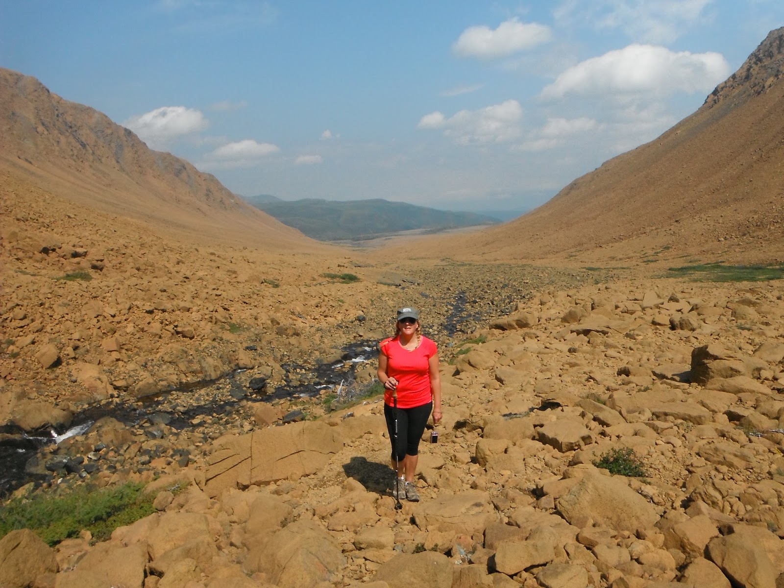 |
| The Tablelands are half-a-billion years old, but it's cliffs and valleys were formed only recently (3 million years ago) when glaciers advanced and retreated over this area....."Isn't that correct Melanie?" |
 |
| Common Juniper is just plain tough. Frost heaves their roots, wind and snow prunes their branches, the lack of nutrients starves them, and the rocky soil holds little water. For this reason, common juniper grows slowly on the Tablelands where they can be hundreds of years old!! True story! |
 |
| It's no walk in the park. There are no trails and there's significant uphill scramble. |
 |
| Lichens grow on these rocks and they are ancient with some being more than a thousand years old. We saw lots of grayish-greenish types of lichen but this was the only orange one we saw. I wonder why? |
 |
| In one of the earliest applications of plate tectonic theory, geologists showed that the Tablelands originated as a slab of mantle from under an ancient ocean crust. As continents collided, about 480 million years ago, it was bulldozed up into the Appalachians Mountains as they were being built. When the collision ended, the ancient ocean had been destroyed and a supercontinent, Pangaea, had formed. The young Appalachians ran down the centre, with the Tablelands deeply buried within. Hundreds of millions of years later, erosion exposed the Tablelands, one of the few places where a piece of the Earth's mantle is exposed. |
 |
| Looking back at Winter House Brook canyon. Its been about 4km of huffing and puffing to get to this point. |
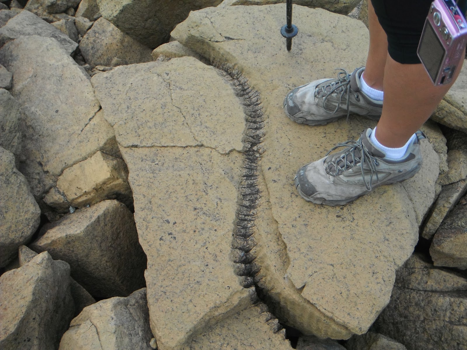 |
| WTF. |
 |
| The selfie miesters! |
 |
| TADA! The top! Our intent is to hike across the barren top to the next canyon and descend there and then hike back to our truck....... |
 |
| ......however Mother Nature had other plans. With no points of reference and steep cliffs, we decided hiking across the top would not be a wise thing....... |
 |
| ......so it's back down from whence we came. |
 |
| Going down was equally challenging as going up but 10km later we arrived. |
Woody Point
They come from far and wide to enjoy the Woody Point Writer's Festival, an event that brought our friends here and we went to spend the night and do some partying!!!

 |
| Goose Cove Phil with his sister-in-law Chantelle, his spouse Bet, his cousin-in-law Gladys and Miss Mel sitting around having a time in Woody Point. |
 |
| Nothing like a good ice-cold Spruce Beer from the micro-brewery in Pasadena while sitting on a deck Galliots Gallery in Woody Point. |
No trip is complete to Gros Morne National Park without doing the......
Western Brook Pond
Surrounded by steep rock walls 2,000 feet high, Western Brook Pond is an inland lake, carved from surrounding plateau by glaciers over millions of years ago.

 |
| In order to get to Western Brook Pond it requires walking an easy 3km gravel & boardwalk trail to the boat launch. |
 |
| Even if a person didn't take the 2 hour boat tour, the views from here are amazing. |
 |
| Let's get this show on the road.....or pond!! |
 |
| We start out under bright sunny skies and it don't take long before we enter the fjord. |
 |
| I had taken this trip back in the early 80's when they were just starting to do tours on the lake. It looks the same sans the rain.!!! |
 |
| The water in this lake is so pure it does not have enough particles in it to conduct electricity.....true story! |
 |
| "Hey Mel, let me take a picture....hold it, hold it.....that's perfect!!" |
 |
| Plunging 650 metres is the Horsetail Falls, one of many falls that fall from atop. |
 |
| The lake is 16km long with a maximum depth of 165m (540ft). She be a deep one! |
 |
| The lake is home to Atlantic Salmon, Arctic Char and Brook Trout plus a cliff dwelling sea gull population. Migrating caribou also swim across the lake to a secluded calving ground that cannot be reached any other way, thus allowing them to calf without fear of coyotes and black bear. |
 |
| End of the tour and the end of this portion of the trip!! |
We continue our trip of Newfoundland & Labrador by heading for Newfoundland's....

Insects


The Port-au-Port Peninsula presents another part of Newfoundland's history. The 161 km drive around the peninsula is also called the French Ancestor's Route. For centuries before 1904 this area was known as the French Shore. Until that year France had exclusive fishing rights in this area which they then relinquished. Many French place names remain as do people of French heritage. This area is designated as the only bilingual area in Newfoundland since 1971.


West Coast
The west coast of Newfoundland & Labrador is unlike any other. A vibrant mix of wilderness, culture, tradition and history shapes this area and ensures an unforgettable experience. Stretching from Deer Lake in the interior to Rose Blanche on the southwest coast, you're never far from the deep blue of the Atlantic Ocean.

Our first stop after leaving the Great Northern Peninsula (see Part 4 in this series) is to Deer Lake to visit the fascinating world of......
Insects
Over the last couple of decades the Newfoundland Insectarium has attracted and awed people from around the globe and as a result is considered the #1 indoor attraction in Newfoundland.

 |
| The Insectarium has welcome 390,000 visitors since it open. Mel makes it 390,001..... |
 |
| There are thousands of mounted insects adorning the walls..... |
 |
| .....but it is the live butterfly garden that is undeniably the most unique feature. Hundreds and hundreds of colourful and fluttering jewels of nature. |
 |
| There's nothing in a caterpillar that tells you it is going to be a butterfly. |
 |
| "Float like a butterfly, sting like a bee."
Muhammad Ali
|
 |
| You can only fly once you have given up the safety of the cocoon. |
After visiting the Insectarium it was onward to visit our friends, Bernie & Stew, who live in Pasadena which is part of the........
Humber Valley
Set along the banks of the Humber River, the Humber Valley is nestled in the foothills of the Long Range Mountains and stretches 70 kilometres from the town of Deer Lake, to the city of Corner Brook. This area is an haven for the outdoor adventurer which includes the best downhill ski mountain in Eastern Canada, Marble Mountain.

 |
| Hanging out at the Pasadena Beach having a cold brew on a hot day with awesome friends, Bernie & Stew. |
 |
| Mel & Bernie hanging out by the fire at Jeremy & Sherry's cabin on Deer Lake. |
 |
| A view of Newfoundland's second city, Corner Brook, and its pulp & paper mill. This picture was taken from Captain James Cook Historic Sight: James Cook came to Newfoundland in 1762 at the age of 34 and spent the next six years surveying and mapping Newfoundland waters. Later he would go on to bigger discoveries in the Pacific Ocean including Australia, Hawaii and New Zealand. |
 |
| Captain James Cook, when surveying Newfoundland, was in the habit of employing local pilots to point out the rocks and hidden dangers. In the 1765 season, Morgan Snook III from Fortune Bay, was employed by Cook: Morgan Snook is my Great-Great-Great-Great-Great-Grandfather.....just saying!! |
While we were staying in Pasadena we wanted to take advantage of the many trails in this region, so we headed out (along with our friends of Bernie & Stew) for beautiful Bay of Islands to hike the......
Cape Blow Me Down Trail
The trail is part of the international Appalachian Trail and is located 30 minutes from Corner Brook. Previously known as the Copper Mine to Cape Trail it ascends 660 metres from the large parking area to the top of the Blow-Me-Down Mountains.
 |
| There she be....all 660 metres of her. Big rock! |
 |
| The trail begins at the abandoned 100+ old copper mine (it's entrance is cemented close). From here it's 3.8kms to the top. |
 |
| It's a steady up and it's muggy out, making this hike a work-in-progress. |
 |
| Half way there and time for re-hydration. That nipple on top of the mountain in the background is our destination. |
 |
| We have left the trees behind and entered alpine meadow and it looks like we are almost there right? Nope.......... |
 |
| ........still got a ways yet! |
 |
| Bernie and Stew halfway there....you go guys! |
 |
| Almost to the top now: Looking out over the flatten tops of the Blow-Me-Down Mountains. |
 |
| Remember guys, "Perseverance is the hard work you do after you get tired of doing the hard work you already did." |
 |
| TADA! The view from up here of the Outer Bay of Islands is astounding. |
 |
| Looking down from 660 metres up! |
 |
| Back down and we do a quick detour to the Copper Mine Brook Falls! |
 |
| Having a celebratory beer at Bottle Cove after the climb! |
We liked the Outer Bay of Islands so much that we decided to go back, so we drove out to the village of.....

Our real reason for coming here was to do the two trails of.....
Cedar Cove and Little Port Head Trails
The Cedar Cove is a 1.8km trail and is considered easy with spectacular scenery nestled between mountains. The trail ends at beautiful Cedar Cove. Double back a short distance and branch off onto the 5.5km Little Port Head trail. A steep trail requiring the use of ropes and stamina.

Lark Harbour
The fishing town of Lark Harbour is also known for it's spectacular scenery and hiking trails, and we came here for both.

 |
| Bottle Cove has been converted by the town of Lark Harbour into a municipal park |
 |
| The wharf in Little Port in the midst of the food fishery season with the Lark Harbour Dory. They are effective workhorses and are light, manageable, strong and dependable......much like myself. |
 |
| The town built a boardwalk around Bottle Cove plus a couple of short trails. |
 |
| Climbing up towards the "Chimney" for a better view. |
 |
| Now this is a better view. |
 |
| The purse-seiner fishing for herring just offshore. It was interesting to watch from shore as they started hauling their nets. |
Our real reason for coming here was to do the two trails of.....
Cedar Cove and Little Port Head Trails
The Cedar Cove is a 1.8km trail and is considered easy with spectacular scenery nestled between mountains. The trail ends at beautiful Cedar Cove. Double back a short distance and branch off onto the 5.5km Little Port Head trail. A steep trail requiring the use of ropes and stamina.

 |
| Our hike would take us around this big lump and down to Cedar Cove on the other side and then when we double back we would go up and over this same lump. |
 |
| Approaching Cedar Cove. |
 |
| Something was stinking and we could smell it long before we could see it....... |
 |
| Cedar Cove beach and the source of the big stink. Notice the decomposing whale carcass in the lower right hand corner. A local hiker told us that it washed up on shore about a month ago. |
 |
| The sign states it all: "Extreme Trail", "High cliffs / Ropes".......we love this stuff. |
 |
| We met another couple coming in the opposite direction who stated that "it was really steep on the other side." |
 |
| Looking back at Cedar Cove. |
 |
| I was surprise at how steep this trail actually was. The ropes weren't a luxury but a definite necessity. |
 |
| Up and up and up! |
 |
| Looking out at part of Lark Harbour with Bottle Cove in the background. |
 |
| Nearing the top, but remember, what goes up must go down. |
 |
| At last, the top! Not much growing up here except rocks. |
 |
| Looking south from the top....... |
 |
| .......looking north from the top........ |
 |
| .....and finally, looking east. |
 |
| Like I said earlier, 'what goes up must go down.' |
 |
| Half way down and looking at Little Port. |
We pack up our trailer and head for the.........
Port au Port Peninsula
Port au Port Peninsula
The Port-au-Port Peninsula presents another part of Newfoundland's history. The 161 km drive around the peninsula is also called the French Ancestor's Route. For centuries before 1904 this area was known as the French Shore. Until that year France had exclusive fishing rights in this area which they then relinquished. Many French place names remain as do people of French heritage. This area is designated as the only bilingual area in Newfoundland since 1971.

After getting our trailer set up in Kippens, we head out to explore the weird and wonderful by checking out the........

Ancient Carboniferous Fossil Trees
The fossil beds along Blanche Brook provide a rare glimpse of the remains of 305 million year old tropical Cordiatalean Trees. The giant 50 metre (160 foot) trees grew on a mountain range when the island of Newfoundland was part of the great continent Pangaea. At the time the bedrock we stand on was situated in the mid-Atlantic Ocean near the Equator, about 2,000 kilometres from here.
 |
| The fossils embedded in the sandstone on the riverbed are pieces of trees that washed down a mountainside and were deposited in a river delta. These trees were buried by sand are are now being exposed by natural erosion along Blanche Brook. |
 |
| Cordiatalean Trees were one of the first seed-producing tree species to inhabit the earth and are now long extinct. |
 |
| "Some heavy for a chunk of wood.....aaah rock!" |
 |
| These remnants of ancient trees are the oldest known upland tree fossils in the world, however in this brook there were a lot of them lying around. |
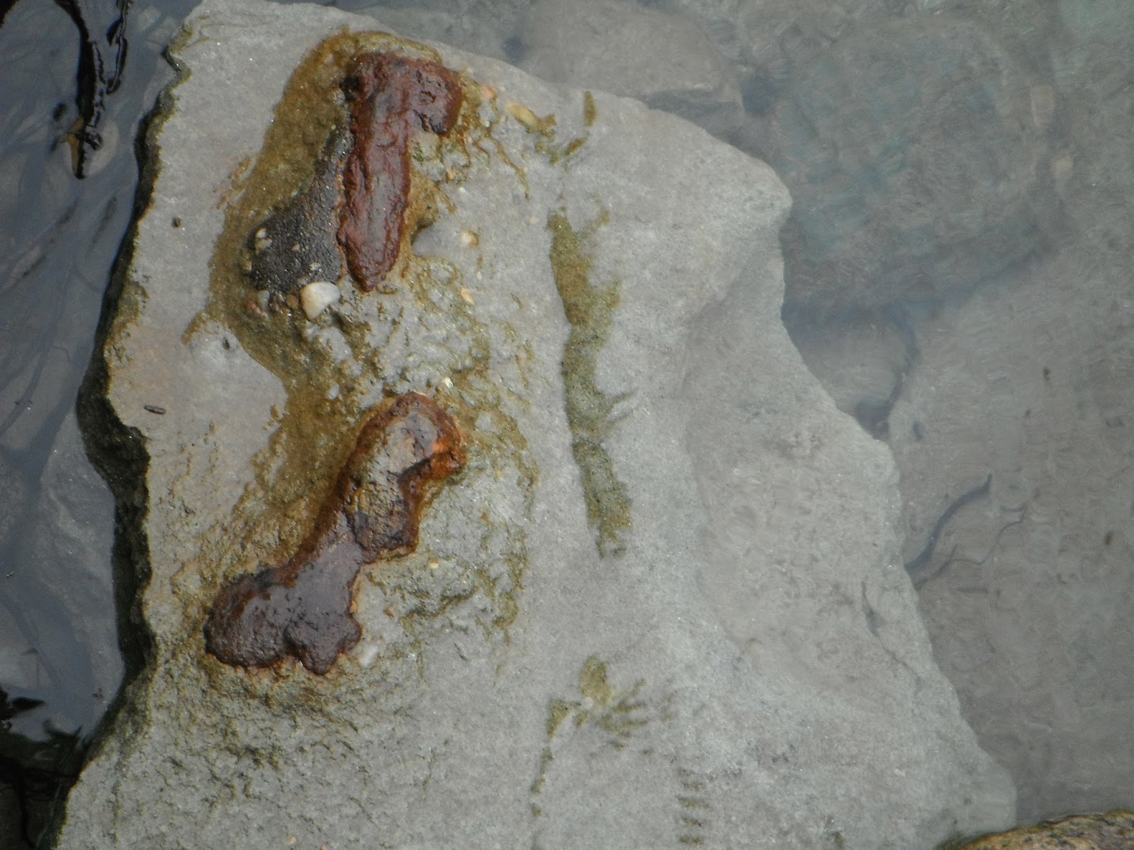 |
| I was looking for other types of fossil when I overturned this rock next to the brook. I don't know....you tell me? Not an ancient tree embedded in this sandstone, but it does look like a broken bone. Maybe???? |
Just a short distance from where were camped is the......
Gravels Walking Trail
The Gravels is the name given to the sand isthmus that joins the Port au Port Peninsula to the island of Newfoundland. It is believed that Jacques Cartier landed on this beach in 1534. By the mid-1800's, the Gravels had become the commercial centre for the region.

 |
| The isthmus - in 1951 this spit of gravel was flooded making the Port au Port Peninsula the Port au Port Island. |
 |
| The trail starts out at the isthmus (the 'Gravels') but once it rounds the headland the coastline changes dramatically (notice the exceptionally large tree trunk). |
 |
| A short side path leads to Our Lady of Mercy Church, built in 1912, it is the largest wooden Catholic Church in Newfoundland (standing 115 feet high). |
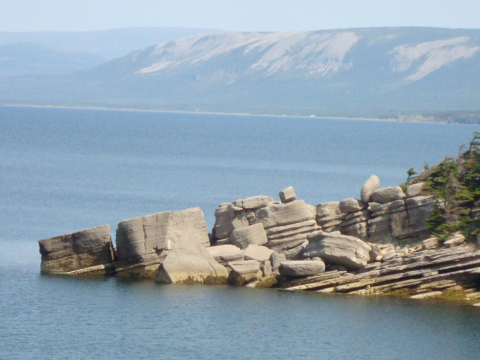 |
| Sloping beds of limestone have been shaped by the winds and waves into curious formations. Note the Lewis Hills across the bay. The Cabox Mountain in the Lewis Hills is the highest point in Newfoundland at 816 metres. |
 |
| Gushue's Cove Bridge along the 7km trail. |
 |
| The rocks here look something like the ones we saw in Port au Choix (see Part 3 of this series). |
 |
| The locals call these rock formations 'Hoodoos'. "Hoodoo you love Melanie?" |
 |
| The entire length of this trail is flanked with the hoodoos. |
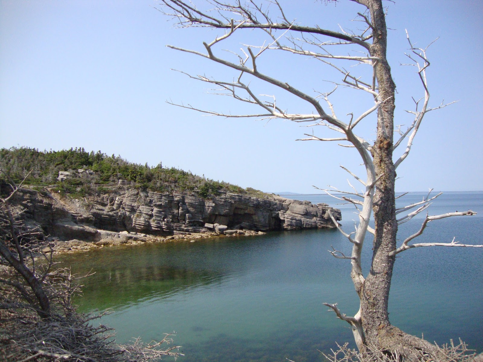 |
| The scenery is breathtaking, especially on this bright sunny (& warm) day. |
 |
| These limestones also contain fossils - the remnants of life from a tropical ocean 400 million years ago. |
 |
| It didn't take long to spot a fossil. Looks like some kind of large snail. |
We travel further up the coast of the Peninsula to the village of......


Sheaves Cove
We pulled into this tiny village to look at the "hidden" waterfall, which isn't actually hidden, you just can't see it from the highway. It turns out to be a delightful place to see more hoodoos and talk to the locals.
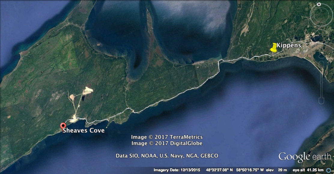
 |
| The not-so-hidden Hidden Falls. |
 |
| Hanging out in Sheaves Cove! |
 |
| The limestone ledges of this brook give it the infinity pool look. |
 |
| Personally, I thought it looked pretty cool how the brook cascaded to the ocean. |
 |
| I call this piece "Pebble beach with Hoodoos and Ship." |
 |
| Local fishers coming back from jigging a few fish. |
 |
| The same local fishers landing on Sheaves Cove beach, no wharf here, just a boat winch!!! |
 |
| Salt-of-the-earth fishermen quick with a joke and offering up a feed of fish. |
 |
| Meet supper; "Mr. Sculpin and Tommy Cod." |
It wasn't all sunny and bright weather on the Port au Port, so when our friends Don & Denise arrived amidst a storm, there wasn't a lot to do but take a road trip around the peninsula.
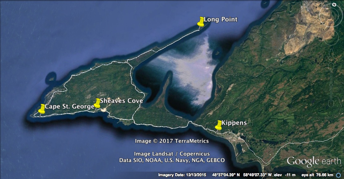
 |
| Nothing stopping the big sea from pounding these shores except mainland Canada. |
 |
| Newfoundland is famous for its critters, such as the Newfoundland dog, the Labrador Retriever, Salt Water Rabbits and Wild Bologna but Alpacas???? |
 |
| It's a different sea crashing into Sheaves Cove today. |
 |
| Haystacks, something you don't see too much of in Newfoundland. In fact, I've never seen in Newfoundland. |
 |
| A house in Mainland. Like WTF? |
 |
| Drove all the way out to Long Point for a look. |
 |
| Finished the day off with a feed of Don and Denise's homemade Blueberry cake. Yummy!! |
After the weather improved we headed back the peninsula to hike the.....
Boutte du Cap
Near Cape St. George, the cradle of Newfoundland's francophone culture. This trail leads uphill towards two kittiwake colonies that nest on the 200+ metre plus cliffs. Vue spectaculaire!

 |
| These unstable cliffs should be approached with caution. Only a few weeks before we arrived, a local man fell to his death when the cliff under his feet gave way. |
 |
| The trail hugged the coastline for a good portion of the hike but we never saw any kittiwakes (I expect they had all flown the coup). |
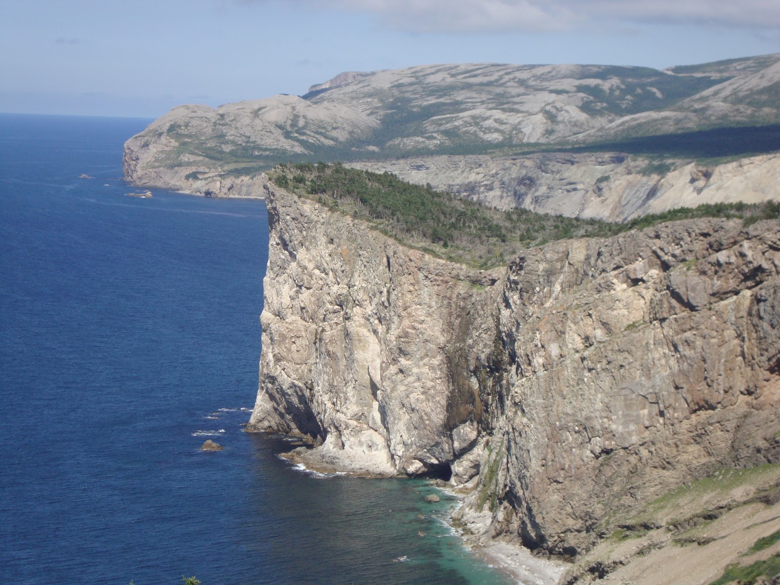 |
| The ruggedness of the Newfoundland coastline never fails to amaze me. |
 |
| That's Red Island in the distance. L'lsle Rouge was a major summer fishing station from the late 1700s and was still considered the best fishing station on the west coast as late as 1862. There were as many as 300 men on L'lsle Rouge in the late 1800s, but now no one lives there. |
 |
| The trail peters out after here, so we turn around and head back (you may note the trail running parallel to the cliffs). |
 |
| Melanie's good friend, Paula, lives in Cap Saint-Georges and we spent a night hanging out with her and her family. |
We leave the Port au Port peninsula region and head for a day in.....
Barachois Pond Provincial Park

Barachois Pond Provincial Park
We came to this beautiful provincial park, Newfoundland & Labrador's largest, to do the Erin Mountain Trail.


 |
| The first section of the trail travels over well maintained boardwalks through boreal forest (our destination is the hill in the background). |
 |
| The trail climbs steadily and it gives us quite the workout. |
 |
| At the 340 metre summit we are awarded with a panoramic view of Bay St. George & the Gulf of St. Lawrence. |
 |
| A view of Barachois Pond Provincial Park with the campgrounds on the spit of land jaunting out into the pond. |
 |
| It's as close as Melanie would let me go.....actually it's as close as I want to go! |
We continue our journey south and head for the......
Codroy Valley
The Codroy Valley is known for its fertile soil; magnificent Wetlands area, its excellent weather conditions and its rich fishing grounds off the coast. Surrounded by the Anguille Mountains to the northwest, the Long Ranch Mountains to the southeast this area offers excellent hiking and scenery.


 |
| The best RV park we've been in while travelling; the Grand Codroy RV Park in Doyles and home for the next few days. |
We drive out to.......
Cape Anguille
Situated at the end of Anguille Mountains, Cape Anguille is the most westerly point on the island of Newfoundland.

 |
| In 1905, because of a disaster that occurred off the coast of Cape Anguille, a lighthouse was erected & it is still in operation today. |
 |
| I was expecting the most westerly point in Newfoundland to be rocky outcrops, but the only rock I could see from this beach was the Long Range Mountains in the cloudy distance. |
During our travels in this part of the world we had heard from many people that spoke of a well marked trail that takes you to the top of the Long Range Mountains, and we wanted to do it. So today we hiked the........

Starlight Trail
In Newfoundland, I would say that the top three hiking trails (excluding the epic East Coast Trail) are Gros Morne Mountain, the Alexander Murray Trail in Kings Point and this trail.

 |
| Our goal is simple, take the trail to the top of the spectacular Long Range Mountains. |
 |
| The Starlight Trail starts gently, taking you over boardwalks and through birch forest...... |
 |
| .....after about 1km., you begin to climb up along the side of the mountain and the vegetation goes from forest to alpine meadows. |
 |
| The ascent is breathtaking (in more ways than one). The view is overlooking the Little Codroy River valley and the TCH. |
 |
| After about a hour of solid hiking we crested the flat top. |
 |
| So this is what is on the top of these mountains. Savannah-like grasslands. |
 |
| Because there are no trees here, you can see in every direction with nothing hindering your view. |
 |
| TADA. Oooh yeah....another one bites the dust! |
 |
| Campbells Lake situated just below a beautiful gorge. Awesome. |
 |
| The Long Range Mountains (part of the Appalachian Mountain Range) dominates this valley regardless if you look at them from sea-level or at 360 metres above sea-level (as in this picture)!! |
 |
| The infamous "Wreckhouse" winds blow here with wind gusts in access of 200km per hour. No wonder the trees grow horizontally here. Judging by the size of the trunk, this old fella has to be over 100 years old. |
 |
| And now we go down. |
We took a little drive up the south coast (known as the Granite Coast) to........

Isle aux Morts
Named after a formerly inhabited nearby island, it is in reference to the many shipwrecks off the coast. Isle aux Morts translates from French into English as "Island of the Dead". It was a beautiful day and we saw no dead, so we decided to stop and have stroll on the town's Harvey Trail.
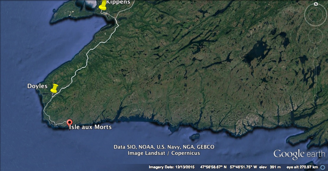
 |
| The Harvey Trail honours the George Harvey family and their Newfoundland dog Hairyman, who saved almost 200 lives in two daring rescues in the early 1800's. |
 |
| The south coast is rocky and barren which is in total contrast to the west coast of Newfoundland a few kilometres up the road. |
 |
| The Harvey Trail winds around the coast before looping back and just skirting the village of Isle aux Morts. |
 |
| Looking out the harbour of Island of the Dead. |
We continue driving up the south coast to the village of......

Burnt Islands
The Burnt Islands, like many Newfoundland coastal communities, developed around the fishery. The sheltered harbour and proximity to rich fishing grounds were the principal factors in attracting early fishermen to this area in 1839-1841. The first recorded settlers settled on what is locally known as the Main in 1839, while families settled the Island part in 1841.

 |
| The 'Island' portion of Burnt Islands, connected by causeway in 1969. |
 |
| Another island, albeit a small one, in Burnt Islands. |
We head further up the coast to the........


Barachois Falls Trail
A 1.6km return trip to the Barachois waterfalls is a quick diversion from the driving.

 |
| Such a gorgeous day. I was here many years ago and it was cold and wet......not so pleasant. |
 |
| The flower of a Picture Plant, which grows in abundance here. |
 |
| From this angle you can't see all 50 metres of the Barachois Falls, but what you do see is impressive. |
We continue onwards to the end of the road and the village of.....
Rose Blanche
The name Rose Blanche is a corruption of the French words, "roche blanche" (white rock) which can be seen. This white quartz was highly visible to the French migratory fishermen when they first approached the shore in the early 1700s.

 |
| Rose Blanche at the end of the Granite Coast drive. I wonder why they call it the Granite Coast? |
 |
| Beautiful day......why not? |
 |
| White granite or 'roche blanche' line this coast. |
 |
| "Jeeeze Mel, I really need a poop!" |
 |
| The Rose Blanche Lighthouse and a fisherman in boat approaching. |
 |
| Tight squeeze. |
 |
| Originally built in 1873 from a nearby quarry the Rose Blanche lighthouse it is the only granite lighthouse on the Atlantic seaboard. |
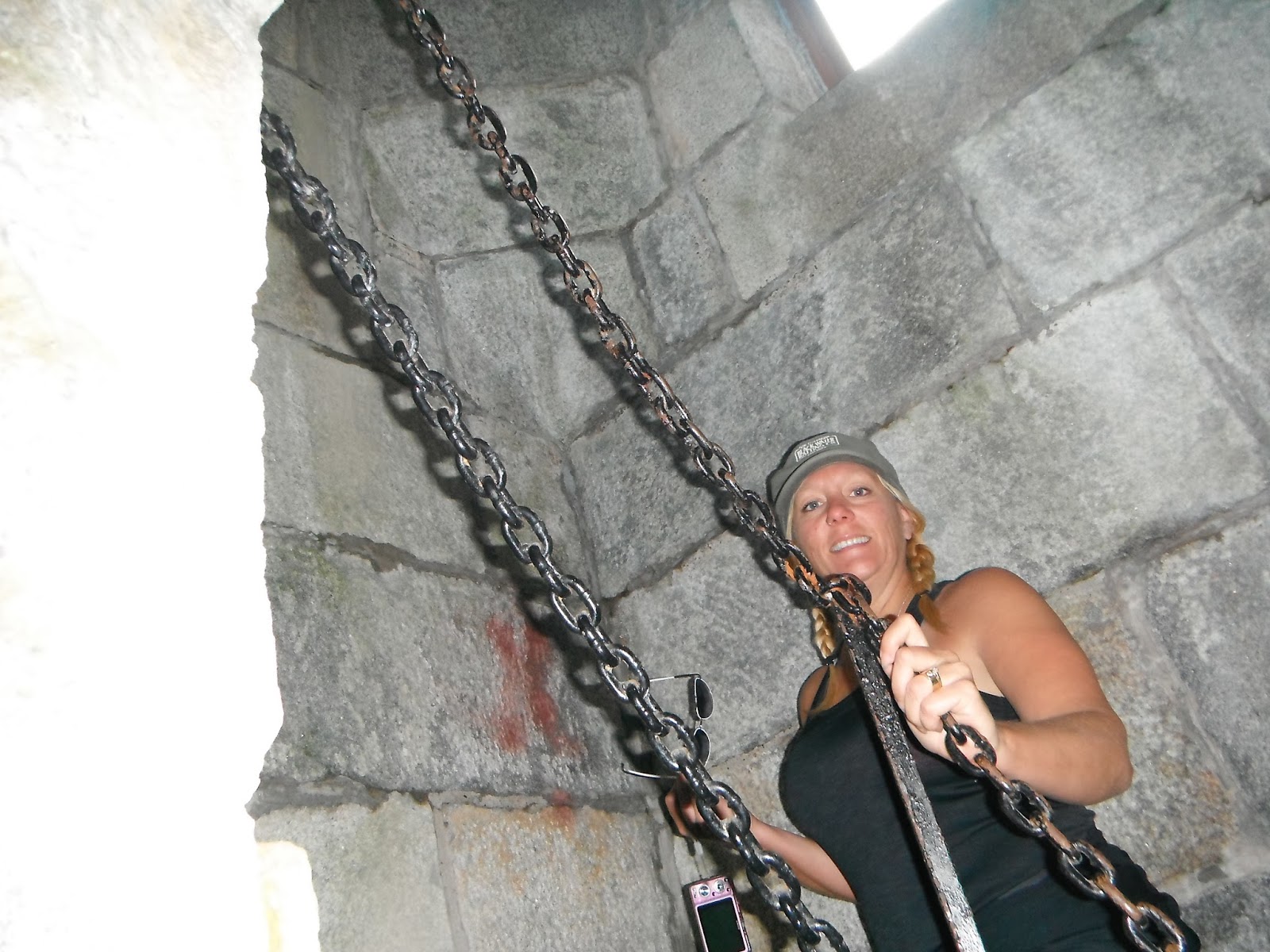 |
| Climbing the spiral staircase to the top at 29 metres. |
 |
| If the weather remained like this, this would be the spot to be! |
We crossed over the neck of land to the tiny village of.......

Harbour LeCou
Named by the French, meaning 'harbour of the neck', this scenic community is nestled between the surrounding granite hills and is only a hop, skip and jump from Rose Blanche.

 |
| Made famous by the traditional Newfoundland song with the same name: "As I rowed ashore from my schooner close by A girl on the beach I chanced to spy Her hair it was red & her bonnet was blue And her place of abode was Harbour LeCou." |
 |
| Good place to hang the laundry, right over the lily-pad pond with the fake Canada Geese. |
 |
| In Harbour LeCou they hang more than clothes on the clothesline.......salt fish drying in the blistering sun! |
We leave the south Granite Coast and head back to the west coast of Newfoundland to climb the.....
Table Mountain


This marks the end of our travels in Newfoundland & Labrador. If exploration tickles your fancy, there is no better place than this province. A vibrant mix of wilderness, culture, tradition and history shapes this land.
We hope you enjoy our little trip and stay tune for further adventures.
Cheers....
Table Mountain
At 425 metres above sea level, Table Mountain trail offers rewarding views of the Long Range Mountains. From 1953 to 1968 this mountain was the site of a radar base, part of the Pinetree Line, manned by the USAF.

 |
| The Table Mountain Trail follows a winding gravel road up a steep, narrow valley (that's the road way off in the distance). |
 |
| It's 2.5km to the top......seems like a long way from here. |
 |
| Nearing the top and looking back at Sugar Loaf Mountain sticking up out of the Wreckhouse lowlands. |
 |
| The narrow valley we climbed up continues on across the treeless barrens on top. This was the only place outside of the east coast of Newfoundland that we were able to see blueberries! |
 |
| Cape Ray, as seen from atop of Table Mountain. |
 |
| "Let's see now. According to my phone GPS, this should be where the USAF base was. Not much here now but these boulders." |
With our time in Newfoundland & Labrador quickly winding down, we head for the ferry-port town of.......
Port aux Basques
With a natural deep water and ice-free port, Port aux Basques has been welcoming visitors for 500 years, from Basques fishermen in the 1500's to ferry passengers who commence arriving on the "Bruce" steamship in 1898. Port aux Basques sits right on the corner of western & southern Newfoundland and the geography around the place reflects both!

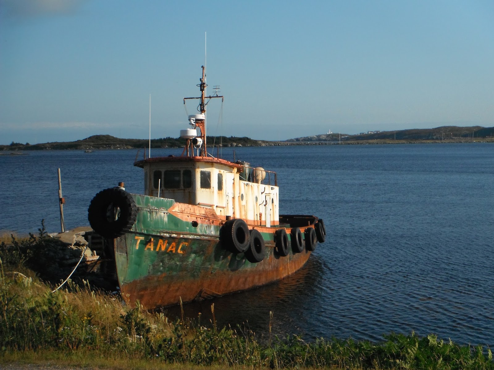 |
| The 'Tanac' looks like it has seen better days! |
 |
| While in the area, we took a walk on the Grand Bay West Trailway which meanders along side a inland bay before heading for the Gulf of St. Lawrence. |
 |
| Two loons had made this area home and they came relatively close to shore to get their picture taken! Thanks guys!! |
 |
| On the western side of Port aux Basques are some of the best beaches you'll find anywhere.....who knew? I always though this area was rock and more rock. |
This marks the end of our travels in Newfoundland & Labrador. If exploration tickles your fancy, there is no better place than this province. A vibrant mix of wilderness, culture, tradition and history shapes this land.
 |
| A fitting picture as we leave Port aux Basques AND Newfoundland & Labrador: Rocky shoreline with a beautiful church and lighthouse! |
We hope you enjoy our little trip and stay tune for further adventures.
Cheers....