"Walking through these islands is like giving a blind man eyes."
Charles Darwin
On December 19, 2023 Melanie and I hooked up with my good buddy, Paul Delaney, and we made our way to the west African nation of........
CABO VERDE
Officially the Republic of Cabo Verde, with only 560,000 residents, it is an archipelago consisting of 10 volcanic islands. Jutting up from the Atlantic, some 500km off the continent of Africa, Cabo Verde is a stunning island chain with captivating blend of mountains, beaches and peaceful seaside villages. Inland; craggy peaks hide piercing green valleys of flower and sugarcane.

Cabo Verdeans have mixed ancestry of Africans, Portuguese, Italians and French. The five centuries of Portuguese colonialism deeply marked the islands, but African traditions and Creole identity are very present.
It has a climate that is consistently warm and tropical all year with average temperatures ranging from 24C to 30C. With each island being uniquely different the most common theme was they all had sun, sun and more sun. Some have beaches, some have a wealth of customs, traditions and musical heritage, some have mountain trails, and some have landscape that springs up everywhere! We spend a full month in Cabo Verde (including Christmas and New Years) and get to visit 5 of the 10 islands - it is truly a paradise.
Cabo Verde is a mere 4 hour flight from Lisbon and we flew to the island of........
Santiago
It is the largest and main island and is home to the capital, Praia, where more than half of the nations residents live (our home for the next 5 days). The island was discovered in 1460 by Portuguese explorers and quickly became an important centre for the transatlantic slave trade. The African culture is definitely more prominent on this island and it is a large part of the rich cultural diversity.
Our home in Praia is the neighbourhood of Plateau, which is built on a plateau, hence the name Plateau....makes sense. It is the oldest settlement within Praia and it is here that you'll find the markets, banks, cafes and restaurants, and shops.
 |
| A common sight. If you can't get to the market then bring the market to you....... |
 |
| ......we, on the other hand, could get to the local market, so we did to have a gawk and buy some local cheese. |
 |
| Relics in Praia from a bygone era when the Portuguese ruled and defended this land. |
 |
Question: How many soldiers does it take to put up a Christmas Tree?
Answer: If you said nine, you'd be correct! |
 |
| Kids having a game of street ball......we use to do the same playing street hockey. |
 |
| We had spent a month in Portugal and Malta trying to find live music, whereas here, it is everywhere. |
While we were on Santiago island we took a taxi to the other side to see the tiny fishing/beach town of Tarrafal.
 |
| Our journey takes us to Pico da Antonia, the tallest mountain on Santiago (1392mts). We wanted to hike this but there was a dust storm from the Sahara blowing through. It made for 'fog' like conditions that lasted for 4 days - true story. |
 |
| To get to Tarrafal we go up and over the mountains.....this was the 'over the mountains' spot. |
 |
| Tarrafal is a fishing/beach town, perfectly situated for both - lots of fish, lots of beach. |
 |
| When the fishermen get back, their boat is hauled up on the beach and promptly swarmed by the ladies looking to get the best fish. |
 |
| The reward for their efforts - a multi-coloured fish for supper. |
 |
| But alas we came to Tarrafal not for the fish, but rather the beach side of things, like you would. After all it is December 21 for gawds sake! |
One day we hiked 4km to the UNESCO World Heritage town of Cidada Velha.
 |
| Our hike will take us into the canyon-type valley behind us. |
 |
| It's a mere 200mt drop into the valley, but it is world's apart. On the plateau it is arid semi-desert whereas the valley is blanketed in lush forest and plantations of sugar cane....... |
 |
| ....and with sugar cane comes the sugar-cane bootleg liquor called "grog".....yes that same 'grog' immortalized in the Clancy Brothers song: All For Me Grog. |
 |
| After trying some grog at the local distributor, our walk resumed, albeit with a lighter gait. |
 |
| We spot the extremely rare Cape Verde Green monkey. It is only found on Santiago and Brava islands and is indeed very rare. How lucky for us to see it in its environment of stealing bananas from the farmers! |
 |
| A 400 year Baobab tree. How it got here is a mystery, a native of Madagascar, certainly not a native of these islands. |
 |
| The further down the valley we hiked the dryer the terrain got. Sugarcane was replaced by corn. Grog salesmen disappeared and was replaced with Corn-hole salesmen. |
 |
| And then we come to the old city....Cidade Velha. It was the first European colonial outpost in the tropics, which makes it the oldest European community in the tropics. Which makes it old. |
 |
| This is Banana Street. The oldest colonial street in the tropics coming in at 1462. |
 |
| The ruins of the Cathedral of Nosso Senhora da Assuncao. If it was still standing it would be one of the oldest churches outside of Europe in the world. |
 |
| Cidade Velha is still a vibrant community with a fleet of fishing boats. |
 |
| The ladies are packing up and heading home, I guess the market is over for another day. |
 |
| A fisherman with his catch...... |
 |
| ......and beer-drinkers with their catch!! |
We fly to our next island destination, the resort-holiday island of........
Sal
Sal owes its name to the mineral that abounds on the island (salt). It is small, flat, arid and with a touch of lunar landscape. Its white sandy beaches, dry tropical climate and warm, clear waters have won over package holidayers who flock here from western Europe in the droves (similar to Canadians flocking to Cuba). The island is basically one large beach with more resorts than people (there is one resort here with over 3,000 rooms) - true story.
 |
| The view from our AIRBNB balcony in Santa Maria (the community you go to when you're not the resort type). |
 |
| Christmas supper. No turkey in this part of the world but plenty of seafood! |
Not being 'beach people', we entertained ourselves by other means, including taking an island tour to see all the sites. The first site was Shark Bay.
 |
| Apparently, there are a couple sharks tied on here somewhere......... |
 |
| ........ two small lemon sharks came by to have a look. The guides were happy there was a successful sighting, the sharks, however, appeared bored . |
The second stop on this journey was to Sal's salt mine, the Pedra de Lume salt flats.
 |
| The mine is situated within the crater of an extinct volcano. The mine is no longer operating but probably makes more money from selling entrance tickets. People come because that body of water you see is second only to the Dead Sea in salinity levels, and thus offer spa-type healing qualities..... |
 |
| ........the salt raises the buoyancy of the water. You'd be hard-pressed to drown in this pond, you float way to high. |
From the salt pans we head further inland through the desert.....
 |
| It doesn't rain here very much - 2ml since August, but amazingly some plants will survive. |
 |
| A mirage: there is no water. It even fooled the camera. |
 |
| All those resorts employ a large group of individuals and this is the community where they live. |
 |
| The local butcher. |
Our final stop of the grand tour was to the 'blue hole', where the hole was only barely blue, but it was a great place to take a dip.
 |
| This is the life hey!! December 26, no stress! |
With the Christmas holiday rush in high-gear we escape to the next island on our agenda.......
Fogo
Even if this was billed as the most boring of islands, we would have to come to Fogo! Just cause! It is in Fogo that the highest point in the archipelago is located at 2829mts., the Pico de Fogo, still active but no longer posing any threat. Definitely, one of the most unique islands in Cabo Verde, with its impressive volcano and a rich history dating back to the 15th century.
The capital of Fogo is Sao Filipe, a charming city with a lively atmosphere and our home for the next 4 days.
 |
| Melanie enjoying the hotel's infinity pool. That's Brava Island in the distance. |
 |
| Melanie's view from the infinity pool. Not bad! |
It wasn't all lazing around in the infinity pool drinking cold beers and reading books. We came to Fogo Island for two reasons: (#1) Having a famous Fogo Island in Newfoundland - to be here and not go.....that makes no sense, and (#2) to climb the beast! Pico de Fogo. It last erupted in 2014, destroying the crater community of Cha das Caldeiras. To get to the climbing area of the mountain we had to drive through that destructive lava field.
 |
| The people that lived in the fertile caldera built their homes in a circular design. This house was in the path of the lava flow when Pico de Fogo erupted in 2014. |
 |
| The caldera, in which the main cone of Pico de Fogo sits, is pretty impressive with massive cliff walls rising 400mts from the crater floor. |
 |
| With the promise of free fertile land and no signs of another eruption any time soon, the people returned and rebuilt on the lava fields. |
 |
| To climb Fogo, which means "fire" in Portuguese, requires an early rise (something akin to getting up to go to work......gag). The rising sun cast a shadow of the volcanic cone on the sun-kissed caldera cliff walls behind Melanie. |
 |
| The beast. |
 |
| Our hike starts at the base of the volcanic cone which is about 1/2 way up the mountain, we'll climb another 1,500 metres. This picture was taken at 500 metres up from the base - you can see the 'new' community of Cha des Caldeiras |
 |
| The goal was to beat the sun. Once it crested the peak the temperature would begin to rise. Cooler temps are preferred when enduring such a strenuous trek. |
 |
| About 1200 metres up. The community of Cha des Caldeiras far off.....down there! Notice the slope of the mountain that we've come up!! |
 |
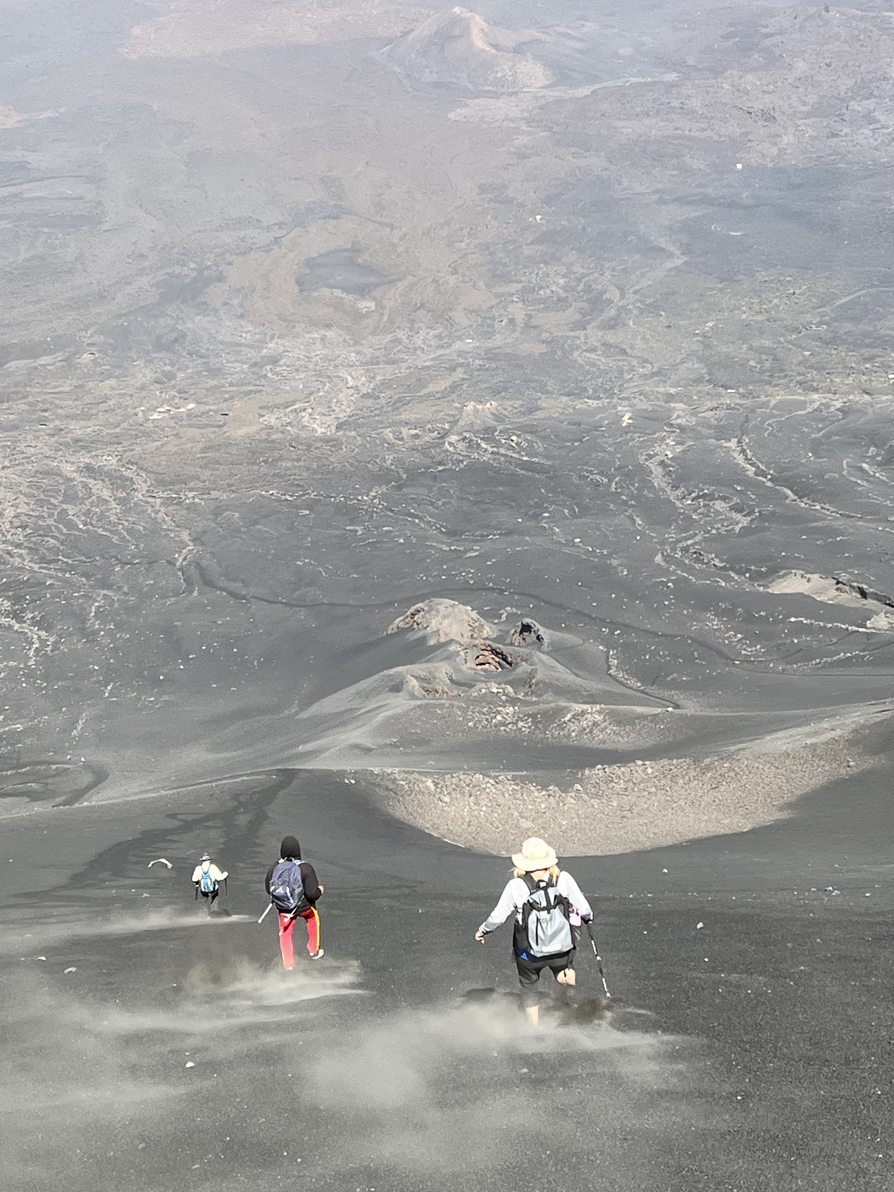
| The top! The smaller caldera on top is still venting obnoxious sulphur gases. |
 |
| Of course, what goes up must come down. A four hour climb up is going to be compressed into two hours going down..... |
 |
| ......it just requires us to get to the 'scree slope', where we'll "ski" down most of the mountain in ankle deep scree. |
 |
| 'Skiing down' the scree slope - combine the angle of the slope and the amount of scree with downward momentum. If you fall, which I did, you continue moving for quite a distance (which I did). |
The next day we are back in the main caldera of Pico de Fogo, but this time instead of heading up we are heading down. We'll hike from the crater lip down 12km to the sea coast town of Mosteiros.
 |
| This hike is different from yesterday's 'thigh-master' workout, here we drop 1500 metres - a real knee buster! |
 |
| From this view you can see a lava field and the island of Santiago off in the distance. |
 |
| Our map had labelled this place a "chapel". I call it a pizza oven with a cross on the top. |
Our time on Fogo had run out and we were off to celebrate New Years Eve on the island of............
Sao Vicente
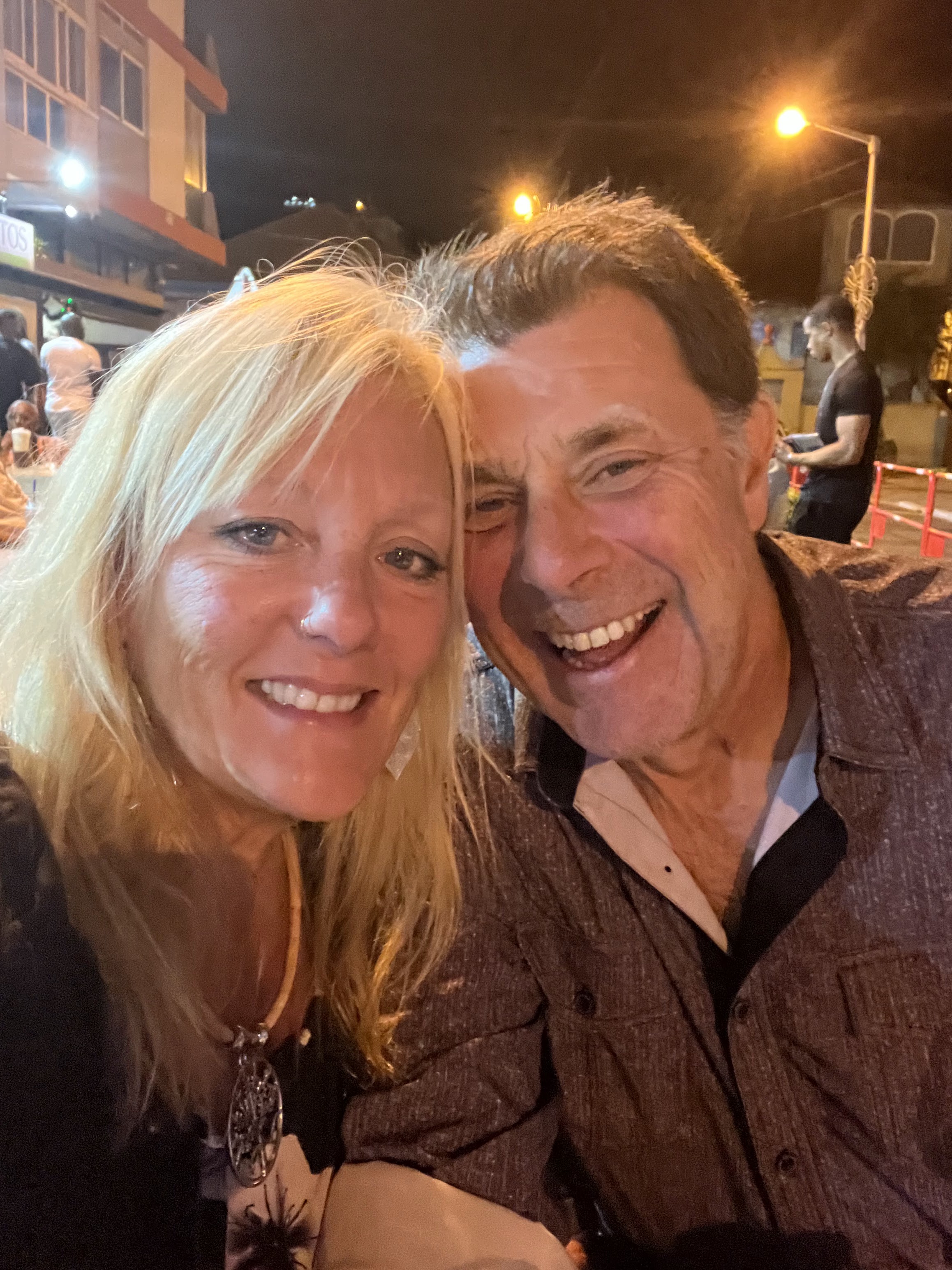
Sao Vicente is home to Cesaria Evora, the Cape Verdean singer that was like a goddess here. We stay in Mindelo, a charming, historic and beautiful city, considered the most cosmopolitan and European of the archipelago, with lots and lots of live music. I researched and this city was THE place to be for New Years' celebration in Cabo Verde.
 |
The Cesaria Evora International Airport. She has an airport named after her, she appears on their 2000 Escudos money bills, she is painted on countless wall murals and I have owned a CD by her for years.....phenomenal singer.
|
 |
| As the sun sets over Mindelo, the wild night of searching for a restaurant begins. Apparently, it being New Years Eve, a reservation would have been a wise thing...... |
 |
| .....we found a restaurant at 10:40, got our meal at 11:20, finished the meal and grabbed a bottle of bubbly at 11:58 and was on the waterfront at 11:59:45 to ring in the new year!!! |
 |
| HAPPY NEW YEAR! |
 |
| We settled into a good ole Irish pub and partied until 4:00AM in the morning. 2024 was starting (hic) out pretty (hic) good! |
While in Sao Vicente we did the things that people do while in Sao Vicente.....such as going for a swim in Turtle Bay!
 |
| There's a fine breeze coming off this southern part of the North Atlantic. Sao Pedro beach is being whipped up....not sure the clarity of the surrounding waters for spotting turtles......nothing a couple of beer won't fix! |
 |
| Alright, before all you animal-huggers out there start emailing me stating that I shouldn't touch the turtles, I just want to say, in my own defence, he banged into me, I was simply pushing him away....that's my story and I'm sticking to it. |
 |
| How this works is you hire a local fisherman to take you out the bay to where the turtles are doing turtle things and then you go for a snorkel. There were five Hawksbill turtles hanging around our area!!! |
 |
| Turtles turtles ya ya ya. |
 |
After nearly an hour of snorkelling we needed a cold beer to wash the salt away.....another story that I'm sticking to.
|
Besides snorkelling with the turtles we also took a little trip to see the rest of Sao Vicente island.
 |
| Our first stop was the highest point of land on the island, Mt. Verde. |
 |
| The top of the Mt. Verde mountain is one of the few places on the island where enough moisture accumulates to allow crops to grow, hence the name I guess....... |
 |
| .....the crops they grow on the mountain are directly related to this guy, the local grog-man, and his various mixtures of grog! All for me grog, me jolly jolly grog. |
 |
Mindelo. Cape Verde's second largest city as seen from the top of Mt. Verde. Santo Antao Island is across the bay.
|
 |
| Our second stop is at the windsurfing capital of Salamansa Bay. Big waves. Big wind. Big fun (at least by the looks of it). |
 |
| ....Paul gave it a go. "Aaaaah I think you're supposed to stay on the board Paul." OK I lied, that's not Paul, but I still think you're supposed to stay on the board! |
 |
| The village next to Salamansa Bay is unique in so much that all the houses are used by local artists to create works of art. |
 |
| The sand, apparently, is imported via the winds from the Sahara Desert. Who knew? Here I'm doing my best Terry pose (private joke). |
 |
| Barren, bleak, hot and dry......similar to Newfoundland without the 'hot and dry' part. |
 |
| Sao Vicente's interior with Mt Verde in the background. Once upon a time the old windmill in the picture was used to pump water to the surface, but the aquifer has long gone dry, now desalinated water has to be trucked in to grow the crops. |
We hop on the ferry and cross the strait to our final destination on this trip, my fav., the island of.........
Santo Antao
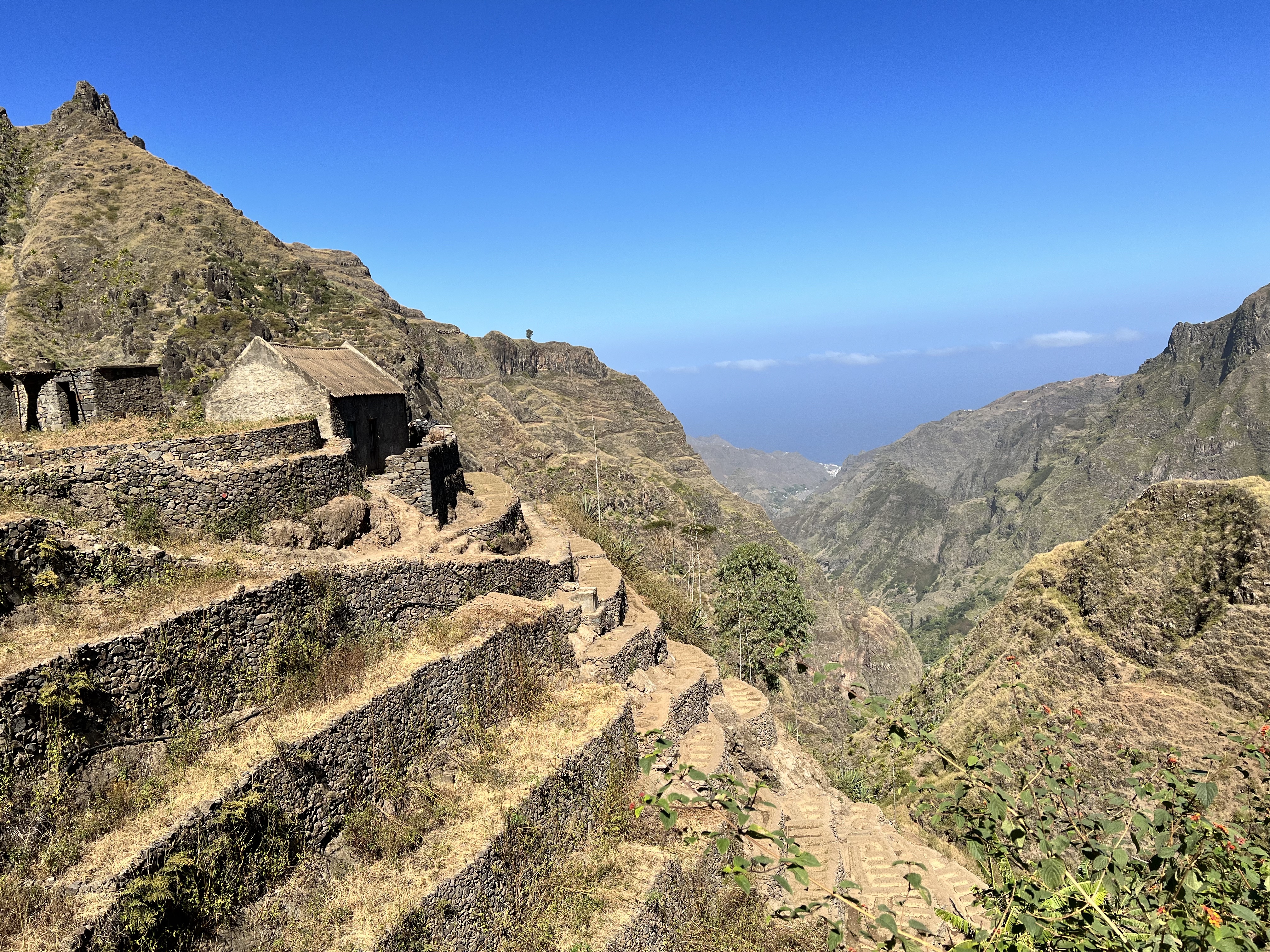
The westernmost island in Cape Verde and the second largest in the country. It is an island where towering green peaks and fertile craters meet cliff-hanging villages and it offers a new adventure at every twist and turn. It seems worlds away from the golden sands of Sal and offers adventurers the opportunity to embark on hiking and sightseeing explorations, in a place relatively untouched by tourism. Unfortunately, Melanie broke her big toe the night before we arrived and this, effectively, ended her opportunities to hit the trails.
 |
| We are staying in the village of Ribeira Grande on the other side of the island from the ferry terminal. There are two ways to get there - coastal road or mountain road. We decided to get there via coastal road and will leave from there via the mountain road. |
 |
| Rugged landscape is the norm here. If you come to Santo Antao for the beaches, you're on the wrong island..... |
 |
| .....that's not to say that there isn't places to swim! |
 |
| Small colourful villages cling to the sea cliffs and a way of life that has existed for hundreds of years. |
 |
| They call this hunk of rock, the Sphinx of Cabo Verde......no idea why? |
 |
| Our home for the next 6 nights - Ribeira Grande.... |
 |
| Our host - Totone Guetta and his sidekick, Black. Totone is somewhat of a local celebrity (check out his YouTube videos) who could have been someone but chose the simple life instead. He was an outstanding musician!! |
For our first hike, Paul and I (remember Melanie broke her big toe and couldn't) headed up the Ribeira Grande valley to Xoxo: pronounce so-so. We took a local aluguer (a taxi - usually the back of a pick-up truck) to the starting point.....and we were off!!!
 |
| The Xoxo Rock, a tall pointed finger-pinnacle, that could be seen from just about everywhere during our trek, was our starting point. |
 |
| These trails are used by the locals to get to their homes. No roads here! |
 |
| Paul had his hip replaced earlier this year and he wanted to demonstrate how the hydraulics worked. He put the hip into super-mode and did his thing.......good job on the pole-bending Paul! |
 |
| Looking back at Xoxo village and Xoxo Rock. I was thinking this was as high as we would go.....boy was I ever fooled! |
 |
| Cliffside villages only reachable by huffing and buffing up the mountains. |
 |
| And still we went higher. Reminded me of trekking in Nepal. |
 |
| It may not look like it but I was having fun and a mild heart-attack! |
 |
| We finally reached the top. If you suffer from vertigo, this is not the place to be....over 1300 metres straight down. The Xoxo Rock can still be seen from here! |
 |
| What goes up must come down. Time for some knee busting! |
 |
| Many would ague that going down is actually harder than going up. I'm not one of those silly people! |
 |
| It would seem to me that getting a massive refrigerator up here would be a real chore. |
 |
| The beauty of trekking. We finish several hours later only 50 metres from where we had started. I know many of you are asking, 'well what is the sense of that'.......none that I can see but the beer was cold! |
Day 2 and Paul had picked out a trail the next valley over. Again we flag down an Aluguer and head to our next destination. We locate the trail head and off we go......only to lose the trail 30 minutes later. We would never find it again....c'est la vie.
 |
| The trail started out on a pretty well defined path through a beautiful pine tree forest. |
 |
| We break out of the pine forest and see the valley we are supposed to descend into......if only we could find the trail to take us there. |
 |
| The only signs of a trail were the old terraced farm trails, which all seem to lead nowheres but through farmer fields. |
 |
| After a couple of hours of wandering up and down this part of the valley we decided to call it a day and head back from whence we came. |
 |
| We got to the road and this Missus, who was picking through white beans, had a "bar" across the street, so we went and had a couple of brews while we waited for our taxi...... |
 |
| ....as it turns out, her "bar" was her living room, but she didn't seem to mind us sitting there sucking on the coldest beer in Cabo Verde. If she didn't mind, we didn't mind!!! |
We had one last trek that we wanted to do and that was to descend into the Valley of Paul. Yes that is the name of the valley.....
 |
| The trek starts with us hiking down into this ancient caldera. It takes us close on 40 minutes to hike down into the caldera and back up out of it. It'll be the only uphill part to the hike!!! |
 |
| Paul about to descend into the Valley of Paul. Jeeese....how come he gets a valley named after him? All I got was a movie named after me! |
 |
| 1,400 metres down. Notice the zig-zagging trail down the cliff face??? |
 |
| Levelling out as we near the bottom. |
 |
| The village of Paul comes into view. |
 |
| A smart entrepreneur. Set up a grog and cold beer stand about 2/3rds of the way down or 1/3rd of the way up.....depending on your point-of-view. |
 |
| The bottom of the valley is very fertile with lots of veggies and sugarcane growing.....and shade (thank God). |
 |
| Laundry day in the Valley of Paul. They had clothes lines but chose the rooftop instead to dry the stuff. |
With our time in Santo Antao coming to an end, it was time to pack up and head back. This time we chose to take the mountain road back to the ferry. This would allow Melanie to see some of the island as her broken toe had kept her housebound.
Our first stop was to the cliffside village of Fountainhas.....
 |
| The hair-raising drive along the cliffside road. Time to stop for a photo! |
 |
| DAMN. |
 |
| More than one way to skin-a-cat. |
 |
| A view of Fountainhas beach. Notice the terraced fields going up the cliffside? It's a hard way to farm, especially if you have to lug your crops up the hill. |
 |
| A view of the beautiful village of Fountainhas. |
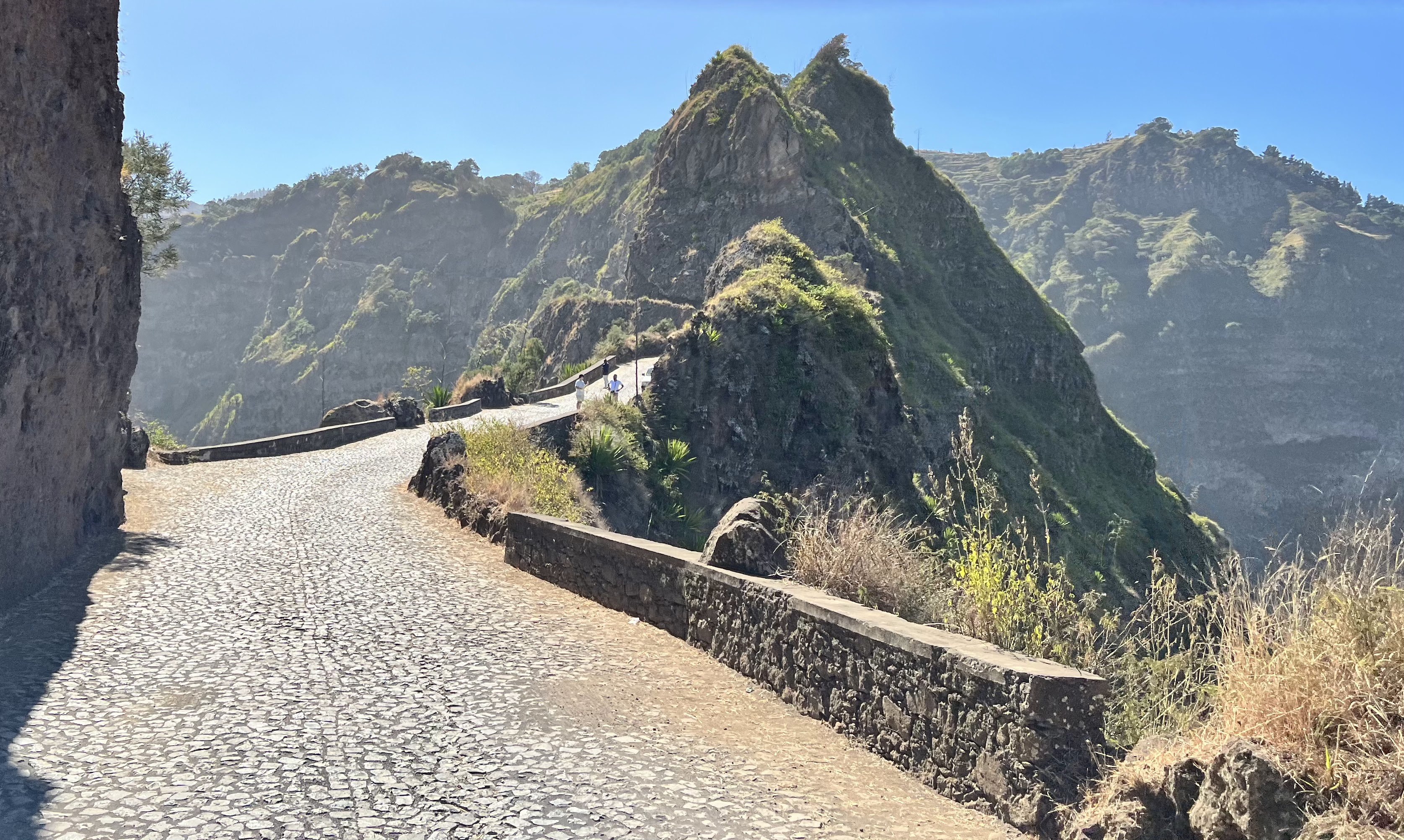
The mountain road snakes along the mountain spine with huge drop offs on both sides. An engineering wonder!
 |
| Ribeira Grande from above. We stayed in that building down there.....just down there . Can't you see it???? |
 |
| A road that's just wide enough for two vehicles to pass with speeds reminiscent of Monaco's Grand Prix. Hang on and buckle up! |
 |
| Tourist. |
 |
| Must be pretty scary during a snow blizzard. |
 |
| Imagine telling the Public Works crowd back home that they had to put a highway on top of this! |
We drove into the interior of the island to look at how the other half lives.
 |
| The interior plateau, being on the leeward side of the island, gets a lot less moisture and is the complete opposite of the mountainous windward side. |
 |
| School kids. |
 |
| The laundrymat is closed today. |
 |
| Water transporter. |
 |
A local on the way to market.
|
Back on track and we stop at the Paul Valley for a gawk and some lunch.......
 |
| A different view of the valley and the trail we hiked down (can you see it?). |
 |
| Not only does he have a valley named after him, but now he got a municipality as well.....God damn it. |
 |
| An Aluguer is the best form of transportation around the Cabo Verdean islands. |
 |
| Our taxi driver brought us to someone's house for beans and wieners....and cold beer! |
 |
| Sao Vicente island appears as we approach the ferry terminal. Now the long journey home begins. |
And with that our trip to the western African nation of Cabo Verde comes to an end.