"To my mind, the greatest reward and luxury of travel is to be able to experience everyday things as if for the first time, to be in a position in which almost nothing is so familiar it is taken for granted."
Bill Bryson
Over the years I have had the opportunity to explore over 40 countries in the world but I have never really explored my own country - Canada. Its ten provinces and three territories extend from the Atlantic to the Pacific and northward into the Arctic Ocean, covering 9.98 million square kilometres, making it the world's second-largest country. Given that this great country is SO large, Melanie and I decided we take a few years and each summer explore some of Canada's ten provinces (see our previous blogs on both 'Newfoundland & Labrador' and 'Nova Scotia').
We start our new adventure in the province of.....
New Brunswick
The largest of the three Maritime provinces it covers 73,000 sq.km. and has a humid continental climate.
New Brunswick is Canada's only official bi-lingual province. It's the province where the people are either French or English but tend to speak chiac, a dialect of rapidly spoken French & English blended together.
Unlike the other Maritime provinces, New Brunswick's terrain is mostly forested uplands, with much of the land further from the coast, giving it a harsher climate. New Brunswick is 83% forested, and less densely-populated than the rest of the Maritimes.
Being relatively close to Europe, New Brunswick was among the first places in North America to be explored and settled by Europeans, starting with the French in the early 1600s, who displaced the indigenous Mi'kmaq, Maliseet, and the Passamaquoddy peoples. The French settlers were later displaced when the area became part of the British Empire. In 1784, after an influx of refugees from the American Revolutionary War, the province was partitioned from Nova Scotia.
Time to hit the road.....
We pickup our stored truck and RV trailer and hit the road. We start our journey in.....
Moncton
Moncton is New Brunswick's largest city and it's the fastest-growing city in the Maritime provinces, with an economy drawn here by the bilingual workforce. Our time in Moncton would be short as our main reason to come here was to rest up and restock our pantry, we did manage however, to get a bicycle ride on the downtown bike trail.
 |
| The Chateau Moncton Hotel can be seen in the distance from the well groomed city trail that skirts the Petitcodiac River. |
 |
| A turtle made from beach garbage! Congratulations to the artist for making such a statement!!! |
 |
| Melanie at the Memorial to three RCMP Officers that were gunned down in 2014 by a loonie-toon. |
 |
| Our bicycle ride ends at the Pumphouse Brewery where we indulged in some local flavours! Like ya would. |
We're soon on the road heading up the Acadien Coastal Trail to the small village of.......
Richibucto
Situated on the Northumberland Strait, this tiny French Acadien town of 1,200 is our base for seeing the area.
 |
| This area falls under the shadow of the largest Acadian flag I've ever seen. Put your joie de vivre up on 10!!! |
 |
| Our campground is located in the Jardine Municipal Park of Richibucto and it is situated near the mouth of the Richibucto River, subjecting it to the tides. |
 |
| A fishing weir, although I'm not sure what their fishing for? The fisherperson will walk out and collect their bounty when the tide drops. |
 |
| The Richibucto River means "river of fire" in the Mi'kmaq language. Not sure where the fire is, but if you want to cross it, this is the place. |
 |
| #TrailerLife: Our salad garden! |
Just 17kms up the Acadien Coastal Trail is the........
Kouchibouguac National Park
Created in 1969, this National Park has endless golden sand dunes and beaches, kilometre after kilometre interconnecting bike trails, and is synonymous with great kayaking opportunities.
 |
| Let the games begin!!! |
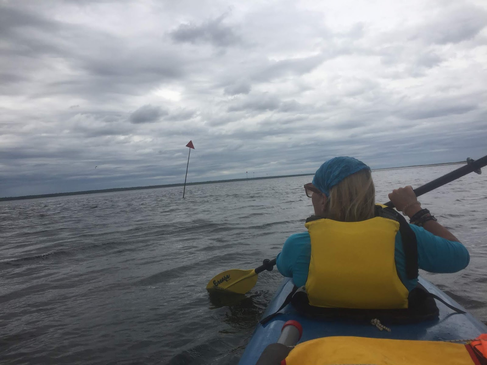
Another kayak trip takes us from Callanders Beach out into the shallow Saint-Louis Lagoon for a 12km return paddle.....
 |
| The lagoon is massive but very shallow (less than 12 inches in most places at low tide). |
 |
| There are three low-lying sand islands in the lagoon that are home to Canada's largest common tern colony. Roasted tern tonight Mel! |
 |
| When the tide is low only kayaks and canoes can navigate the lagoon, otherwise bigger boats must stay in the clearly marked channels. |
We are on the move again, this time to visit my 2nd cousin 1x removed in...
Bathurst.
Situated on the warm waters of Chaleur Bay, New Brunswick's 4th largest city was a mere stop-over for us.
 |
| Melanie & I, with 2nd cousin (1 X removed), Marilyn Pretty, and her husband Paul La Croix (my apologies for the poor quality of the picture). |
Our stay in Bathurst is very short before we are off again to the interior of New Brunswick to visit its largest provincial park......
Mount Carleton Provincial Park
A challenging mix of Acadian woods and Appalachian mountain peaks makes hiking a must-do at this provincial park. This park is also home to the maritimes highest peak, Mt. Carleton, at 820masl (16 metres higher than Gros Morne Mountain in Newfoundland).
 |
| Mel looking at Mt. Sagamook (777masl) from the Armstrong Campground at Mt. Carleton. |
Our first hike was the 5km linear trail....
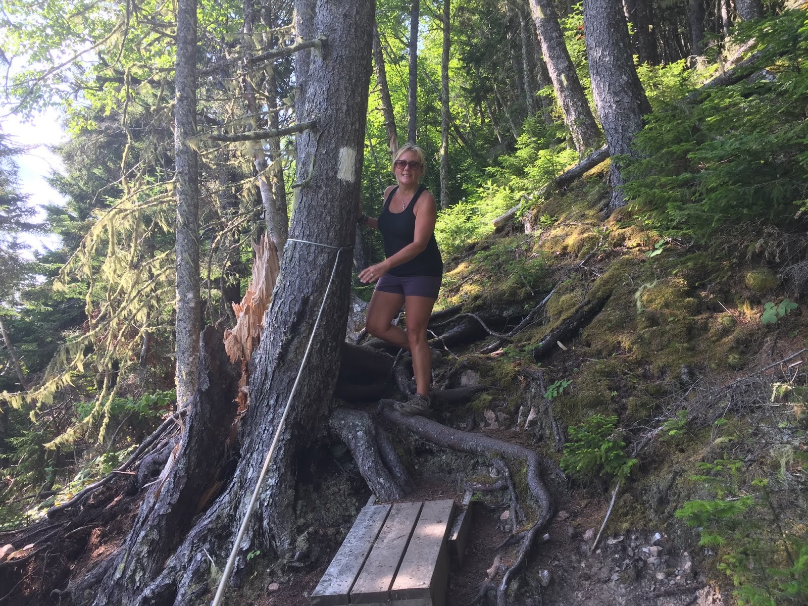
Bald Mountain Brook Trail
We hike up the valley between the Mount Carleton Plateau and Mount Bailey. Along the way we pass by beautiful waterfalls and cross over log bridges.
 |
| Our first hike of the trip to New Brunswick and we picked one rated 'difficult'. We're not-right in the head you know! |
 |
| Right about now I started dreaming of a cold beer!! |
 |
| Woodpecker highrise..... |
 |
| .....Smurf highrise. |
 |
| Just after crossing this log bridge the skies opened and the great rains began. The log bridge washed away and Mel was stuck on the other side for 2 full days. |
Inclement weather played a major part in our time in Mt. Carleton Provincial park, so we took advantaged of a clear sunny day and climbed......
Mt. Carleton Trail
The 10km circular trail ascends along an old access road before reaching the peak (820masl). We cross a long, rocky ridge after the peak before descending next to a lush, mossy stream down the mountain.
 |
| And so it starts again! Nothing like a good stiff climb first thing in the morning. |
 |
| After 5km. of uphill trekking we reach Mt. Carleton peak at 820metres. The shack that is perched on top used to be a Forest Wardens look-out, now it's used as a shelter..... |
 |
| .....check it out Mel. |
 |
| And another one bites the dust. |
 |
| From here I can see over 10 million trees. True story, I read it in the Park Information Brochure. |
 |
| "Jesus Christ B are you sure this is the trail?" |
 |
| "If I get down off this mountain without twisting my ankle, I'm laughing!" |
Time to hit the road. Next destination is the town of........
Grand Falls
The town derives its name from a massive waterfall created when the Saint John River cascades down 23 metres over a series of rock ledges. Grand Falls is also home of Ron Turcotte, the horse jockey of the powerfull horse Secretariat, winner of the 1973 US Triple Crown.
 |
So this is it....the Grand Falls. The Grand-Sault. The Grandes Caídas. 大瀑布. The Grandi Cadute.
I think you get what I'm laying down! |
 |
| There's a zipline over the falls for those so inclined, but this viewing deck is more civilized and cheaper. Notice the pillar of the first bridge ever built over the river gorge........ |
 |
| .....and the 4th bridge to be built over the gorge. You think after the first couple of bridges they get it right? |
 |
| We walk the 2km trail which includes a series of stairs leading down to the river gorge...... |
 |
| .....and Moi in the river gorge. The excitement is overwhelming. |
An acquaintance of ours raved about visiting her hometown of Plaster Rock, near Grand Falls, to see the World's Largest Fiddleheads (those tender shoots of deliciousness), so we did.....
 |
| OK, I admit this was not quite what I had in mind. |
Our journey continues down the Saint John River valley to the home of the World's Largest Covered Bridge.......
Hartland
With a population of less than 1,000 this small village is the hometown of two of New Brunswick's premiers during the 20th century: Hugh John Flemming and Richard Hatfield. As well, U.S. Congressmen Isaac & Samuel Stephenson and Prince Edward Island's Lieutenant-Governor Barbara Oliver Hagerman are also from Hartland (that's a great big WOW from me on that)!
 |
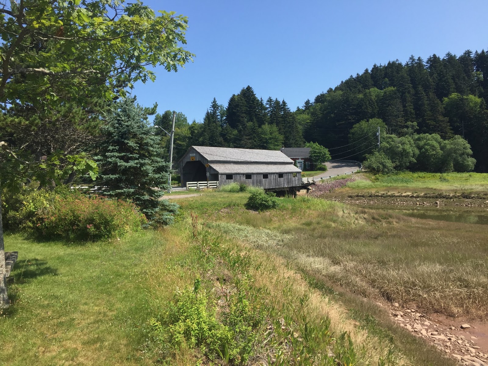
| There are 58 covered bridges in New Brunswick with Hartland being the longest. Originally opened on July 4, 1901, the 391 metre bridge is a National Historic site. Who knew? |
 |
| The bridge was covered as part of major repairs in 1921, this would never happen these days as the cost of all that wood would prevent it. |
 |
| The bridges were known as the "kissing bridges", as they afforded privacy to many suitors to steal a quick kiss while they crossed the river. This bridge is long enough for the suitors to copulate if they so desired!!! |
With little else to do in Hartland we continue onwards to the first incorporated town in New Brunswick.....
Woodstock
Incorporated on May 1, 1856 the town was named after Woodstock, Oxfordshire. The name is Old English in origin, meaning a "clearing in the woods" as opposed to meaning a "a 1969 rock concert".
 |
| "All I said was: It is too bad there isn't a micro-brewery here!" Obviously it was a contentious issue.....regardless my time in jail was short-lived and I was released on good behaviour. |
 |
| We strolled around the town for a bit but with no micro-brewery to hold our attention, we moved on. |
Our real destination for the next few days was the campground located in the village of....
Bear Island
Named "Island of the Bear" by the Maliseet people, the location takes its name from islands (Big Bear and the Little Bear Islands) in the Saint John River. Apparently, bears fished in the narrow channels between the islands, and were also known to frequent the butternut trees native to the islands. With the development of the downstream Mactaquac Dam in 1968 and the consequential rise in water levels, Bear Island is technically a misnomer, as the islands no longer exist.....and that folks is called "Progress".
 |
| We rarely do much on the day we arrive at a new campsite and this time was no different. Here Melanie is enjoying the view of the Saint John River from our campsite..... |
 |
| ......Melanie's view of the Saint John River, which at 637 kilometres, is the provinces longest river and it is also a heritage river that forms part of the Canada-USA border.....twice! |
 |
| Somewhere out there under the water is Big Bear Island and Little Bear Island. |
While checking into our campground, the owner asked 'if we were here for the Craft Brewery Festival?'
"Craft Brewery Festival? What Craft Brewery Festival?", we responded.
She indicated that as far as she knew, the festival was sold out, but the host brewery in Nackawic may be able to get a couple. With that we were to Nakawic with the hopes of securing a couple of tickets.
 |
| Not to be outdone by Plaster Rock's 'World's Largest Fiddleheads', Nakawic has the 'World's Largest Axe'. True story, I kid you not! Seven tonnes of stainless steel rising 15 metres high. They obviously like to build unusual things in New Brunswick to 'world largest' standards. Needs to be sharpened though. |
 |
| We find the beer festival host, Big Axe Brewery (wonder where THAT name came from), but alas all the tickets are sold out, until the owner of brewery (an ex-Newfoundlander) materialised with a way for us to score a couple of the coveted tickets...... |
 |
| ........and score we did; all the craft beer you can drink, transportation to and from the campground, free entertainment...... |
 |
| .....let the games begin....... |
 |
| ....my sunglasses? Anyone see my sunglasses?. |
After the Craft Beer Festival we spent most of our time at Bear (renamed Beer) Island recuperating and trying to remember anything (ANYTHING) of the festival. We decided a bike ride in the capital of New Brunswick might help us with the memory.....
Fredericton
Definitely one of Canada's most cosmopolitan and prettiest cities, the Canadian government named Fredericton the "Cultural Capital of Canada".
Time for a 'And Now You Know' moment: The city of 59,000 was first permanently settled and named Pointe-Sainte-Anne in 1732 by Acadiens fleeing Nova Scotia after the British took over the territory (1710). As the American Revolution came to a close in 1783, British presence in the area increased as Loyalists settled at St. Anne’s Point. Their new home was renamed “Fredericstown” after Prince Frederick, second son of King George III. The town became capital of the new province of New Brunswick, and the centrepiece of Loyalist society. And now you know!
 |
| There are over 115 kilometres of bike trails in Fredericton with many of them following the Saint John and Nashwaak Rivers. I think Mel & I did 100kms of them! |
 |
| The 'Bill Thorpe Walking Bridge', a former railway bridge, spans 581metres across the Saint John River. |
 |
| Da view from da bridge. |
 |
| "Run Forest Run". |
 |
| Government House, the official residence of the Lieutenant Governor of New Brunswick, and immediately behind it (not in this picture) is a small tent city of homeless....the irony is not lost. |
 |
| The Historic Garrison District where British troops were garrisoned from 1784 until 1869. This is one of an unbelievable 12 National Historic Sites in Fredericton. Who knew? |
 |
| City Hall, apparently you 'can't beat city hall', at least that's what I was told. |
 |
| The 1845 Christ Church Cathedral......another National Historic Site and according to the Historic Sites and Monuments Board it is "one of the best examples of ecclesiological Gothic Revival architecture in Canada and it established an architectural pattern followed in the design of many large and small churches in 19th-century Canada". |
 |
| After all of this history I was getting real thirsty so we finish our bike ride at Picaroons Roundhouse Brewing House, one of a whopping 10 brew pubs within the city now making brewskies!! We LOVE this city!!!! |
We pull up stakes and head for the Canadian border town of.......
St. Stephen
Situated on the St. Croix river, this town of 4,500 is known as the southern terminus and entry point for the USA. We weren't remotely interested in visiting Fortress America (not as long as the Trump, the lonnie-toon, is in charged), so we stayed long enough to have a gawk before moving on.
 |
| Fortress America: Calais, Maine directly across the river. |
 |
| Scenes from a border town, the Ganong Chocolate Museum and factory, giving this place the handle: "Canada's Chocolate Town." |
 |
| The old railway station has been converted to a restaurant and craft brewery........ |
 |
| ......aaah now this is GREAT beer, not like the Near-Beer they consume across the river in Fortress America. |
Home for the next week is in the ever-so-scenic village of.......
St. Andrews
Sometimes referred to by its unofficial nickname "St. Andrews By-the-Sea". It is also known as "Qonasqamkuk" by the Peskotomuhkati Nation. LOL.....I prefer the Qonasqamkuk!! Founded by United Empire Loyalist fleeing the American Revolution, many of the Town’s buildings still reflect that history – as you will see during a casual stroll along Water Street. In fact, historic Water Street was awarded the “Great Place in Canada” distinction by the Canadian Institute of Planners, and USA Today named Saint Andrews the best place to visit in Canada.
From our campground we see St. Croix Island, a small uninhabited island in Maine near the mouth of the Saint Croix River that forms part of the Canada–United States border separating Maine from New Brunswick. We go for a paddle.....
 |
| St. Croix island off in the distance. During a boundary dispute between Britain and the U.S. in 1797, the island was deemed to be under U.S. sovereignty by a survey of the river which determined it to be on the western side of its main channel. |
 |
| We paddled out to the island and I wanted to land, plant a Canadian flag and smoke a doobie on American soil, but Melanie talked me out of it...... |
 |
| .....of course, the fact that the Yanks periodically send a gunboat up the river to protect the island from us Canadians was also a deterrent!!! So we quietly paddled around it and headed back to the Canadian side. |
On another day we take a bike ride over to Ministers Island, Canada's largest tidal island and a designated Provincial and Federal historic site.
 |
| This sand & gravel bar connecting the island to the mainland is under 5 metres of water at high tide. The island is safely accessible for five hours during low tide otherwise you best be a good swimmer. |
 |
| The island is riddled with old horse & buggy trails now making perfect bike trails. |
 |
| The sprawling 50 room summer estate of Sir William Van Horne. The railroad visionary, interestingly an American, united Canada by completing the railway coast to coast in 1885. The life & times of the rich & famous. |
 |
| The Van Horne Bathhouse was built in 1912 and provided 'change rooms' and access to the natural salt water pool at its base. The life & times of the rich & famous. |
 |
| The massive and recently restored Minister Island barn. The cows that used to be housed in this barn supplied dairy products to the Van Horne's. When the Van Horne's weren't on the island, the dairy products were shipped to their winter residence in Montreal....oh the life & times of the rich & famous! |
We take our bikes and the 90 minute ferry ride to the largest Bay of Fundy island of.......
Grand Manan Island
At 137 sq. km. in landmass, this large island sports a permanent population of 2,400 residents. Interestingly, the U.S. considered Grand Manan to be its possession due to the island's proximity to Maine (15km away). For many years, the United States and Britain would squabble over the ownership of Grand Manan, however Britain obtained title in 1794 and it's been Canada's ever since.
 |
| "Our ride is here!" |
 |
| Large day on the water. |
 |
| Grand Manan island, voted by Reader’s Digest as one of the World’s 7 Best Small Islands. It's in good company as the other six islands are: (1) Barbuda, Antigua, (2) Lana’i, Hawaii, (3) Cayo Guillermo, Cuba, (4) Washington Island, Wisconsin, (5) Santorini, Greece, (6) Key West, Florida. |
 |
| We bicycle about 15kms. of the island’s 33km. highway, which follows the sea from one breathtaking scene to the next including this place, the Castalia Marsh, where we stopped for a rest and a toot! |
 |
| The North Head Post Office and pizza parlour. Get your mail and a slice of pizza all at once.......such a civilized island! |
 |
| This fella is known around Grand Manan for liking buoys. |
 |
| The Swallowtail Lighthouse is regularly featured in New Brunswick tourism materials and has been recognized by the federal government as "a long-standing symbol of the maritime heritage of the region". True story. I read it on Wikipedia. |
 |
| In order to get to the lighthouse you have to walk, via a bridge, over a deep gully which separates the lighthouse from the rest of the Grand Manan island. |
 |
| The selfie miesters and the heart-shaped herring weir. |
We grab the ferry back to the mainland and head for New Brunswick's second largest city......
Saint John
The city was incorporated in 1785, making it the country's oldest incorporated city. The city’s economy and the weather have both been shaped by its location along the coast. While the rest of the Maritimes were experiencing a heatwave, Saint John was refreshing cool.
 |
| This is a first for us; an outdoor bar/restaurant overlooking the swimming beach at our campground, the municipal park, Rockwood Park. |
 |
| Saint John is where my Uncle Roy Snook calls home. A couple of good lookin' young guys right there! |
 |
| Walking about historic uptown Saint John you quickly realize that wealth lives here and much of it may have to do with........ |
 |
| ....this man; KC Irving (1899 - 1992) took a family sawmill and made it into a multi-billion dollar industry. It is said that 1/4 of the New Brunswick workforce works directly and/or indirectly for KC Irving. |
 |
"Go downtown
Things are great when you are downtown
No finer place for sure, downtown
Everythings waiting for you"
Petula Clark, Downtown
|
 |
| Part of the Saint John City Market, Canada's oldest continuing farmers' market. |
 |
| Artist Sean Yoro (popularly known as Hula) painting a new mural on the waterfront. He can only paint this 28- by 40-foot piece of artwork when the tide is low and while he's balancing on a paddle board. |
 |
| Melanie checking out the Saint John skyline when suddenly a dolphin leaped out of the water and swallow her whole. |
 |
| The Saint John Harbour Bridge. |
Time to hit the road again, this time to the tremendously photogenic village of.....
St. Martins
Once a shipbuilding centre (with over 500 ships built to their credit), this lovely seaside community of less than 300 is gateway to the Fundy Trail. It is also famous for its red cliffs and sea caves.
We launch Big Blue and go for a paddle.....
 |
| Sea cave to the right...to the right....to the right.... |
 |
| ......sea arch to the left....to the left.... |
 |
| .....and under we go! |
 |
| Awesome seascape. |
 |
| High tide in St. Martins harbour. |
We head back to dry land before the Fundy low tide leaves us stranded 1/2 kilometre from where we originally launched.
 |
| Same sea cave that we saw earlier, 'cept now you can walk right up to it..... |
 |
| ....and walk right into it if you are so inclined. |
 |
| And low tide in St. Martins harbour!! |
Our trip to St. Martins won't be complete without taking in part of the.......
Fundy Trail
Hugging the coast of the Fundy Escarpment, the Fundy Trail is a 2600-hectare linear park and ecosystem. This unique 41km. trail is part of two UNESCO designated sites and stretches all the way to Fundy National Park. It is recommended to take 4 - 5 days to hike the trail, so we only managed to see a very small part of it.
 |
| A painted small rock that I found on the trail. I love it!! |
 |
| Before tackling the trail we stop at Big Salmon River for a quick feed. |
 |
| The Fundy Trail starts here at the 84-metre suspension bridge that spans the Big Salmon River |
 |
| 'Stop! Who would cross the Bridge of Death must answer me these three questions: What is your quest? What is your favourite colour? What is the air-speed velocity of an European swallow?" |
 |
| What time of year is it? Mushroom time! |
 |
| As trails go, this was one of the better ones in New Brunswick. |
 |
| Galadriel, the "Lady of the woods of Lothlórien", the greatest of the Elves in Middle-earth, surpassing nearly all others in beauty, knowledge, and power (Mel told me to write this - just saying). |
After a great visit to St. Martins we hit the road and head to.......
Fundy National Park
Opened on 29 July 1950, the Park showcases a rugged coastline which rises up to the Canadian Highlands, the highest tides in the world and more than the normal array of hiking trails. We are staying in the Headquarters Campground for 10 days.....
 |
| As night approaches, this is our view of the village of Alma from the Fundy Headquarters Campground. Alma is the nearest village to the Park and supplies the tourist with everything they need, except a grocery store. Go figure? |
 |
| Upper Salmon River empties into the Bay of Fundy right in the village of Alma. When the tide comes in this will be under water. |
 |
| Alma, like all communities on the Bay of Fundy, have spectacular tidal fluctuations. |
The National Park had an Olympic-size heated swimming pool.....
 |
| Every morning we would head for a swim with the hopes of beating the swarms of crazed kids that descended, like zombies, on the pool throughout the day..... |
 |
| .....Score! |
We took in a Park guided tour of edible foods found in the Bay of Fundy area....
 |
| It don't get any better than this! |
And of course there was hiking, hiking and more hiking!
 |
| The Park's Matthews Head trail took us to a covered bridge..... |
 |
| .....and the view from said covered bridge. |
 |
| Of course the trails in the Park had a good variety of wildlife including this kitten.... |
 |
| ....and the rare Rock Monkey. |
 |
| "Wait a minute. Where did all the water go?" |
 |
| Many of the trails lead down to the Fundy waterline which, depending on the time of day, was either really really close or really really far away! |
 |
| Signs of a time from long long ago. |
 |
| Writer Maimie Steeves, a former resident of the Fundy National Park area, coined the expression "people of the salt and fir" to describe the aboriginal people and their history with the sea and the forest. Fundy National Park saw fit to use this phrase for their printed guide, Salt & Fir. |
 |
| Many of the trails offered spectacular seaside vistas. |
 |
| And many trails took us inland to spectacular river gorges. |
 |
| My favourite trail, the Dicksons Falls trail. |
 |
| Fundy National Park has over 25 waterfalls. |
 |
| I love this shot as the sunlight cuts through the brook mist. |
 |
| The Upper Salmon Brook trail was a sweat buster. |
 |
| One way to beat the heat....take a dip in the river. |
Our journey continues up the Fundy coast to the famous.......
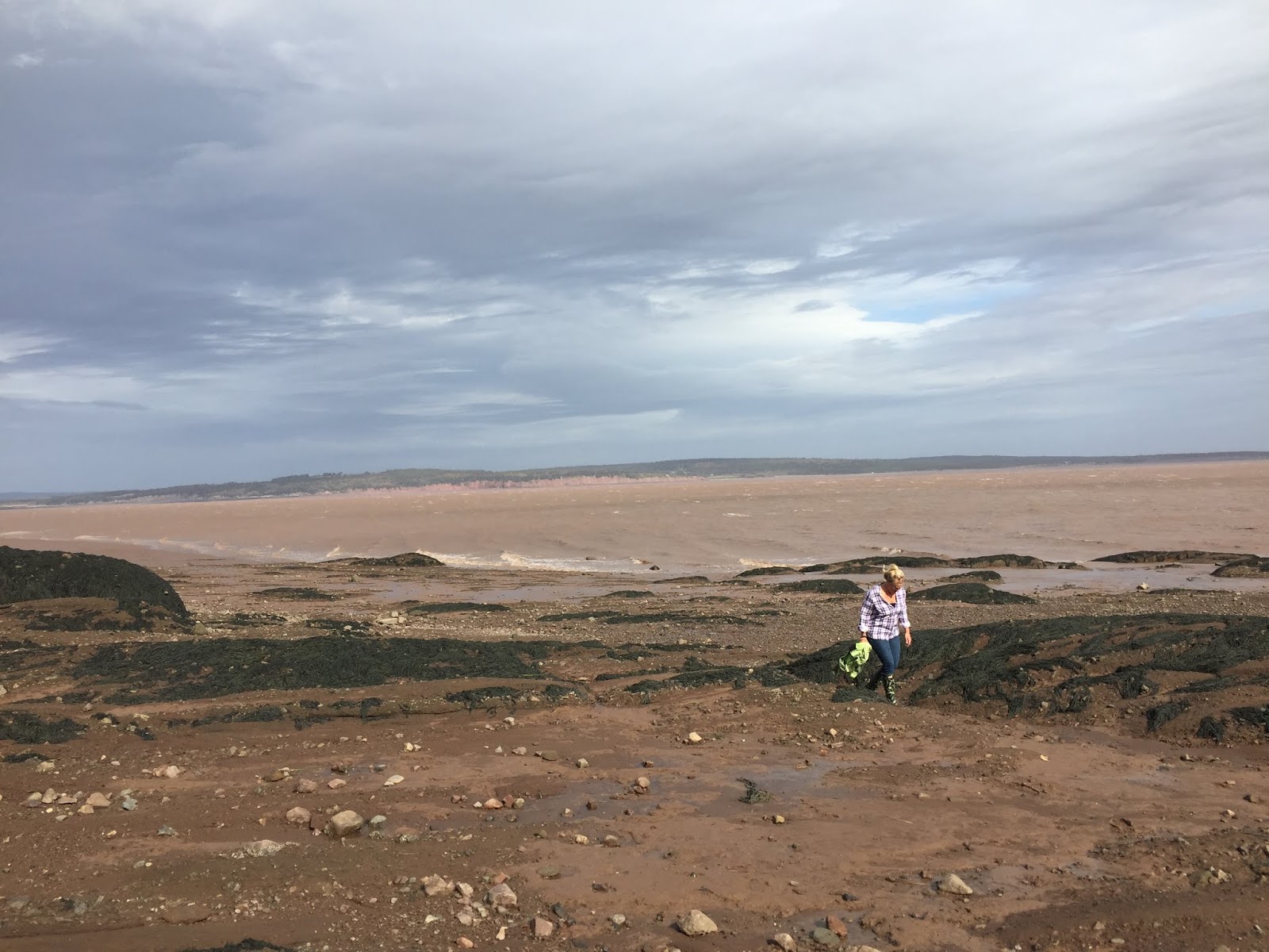
Hopewell Rocks
The Hopewell Rocks, also called the Flowerpots Rocks, are rock formations or sea-stacks caused by tidal erosion. These sea-stacks stand 40–70 feet tall.
 |
| The Hopewell Rocks, New Brunswick's #1 tourist attraction. |
 |
| There are a couple dozen of these massive sea-stacks at the Hopewell Rocks site. |
 |
| Exploring the muddy seafloor. |
 |
| On March 14, 2016, a part of one of the Hopewell Rocks collapsed. Officials said approximately 100 to 200 tonnes of rock fell to the ground. No shit! |
 |
| A photographers paradise. |
 |
| Got 'er rubber boots on! |
 |
| Doing my best Rambo impersonation. If you look real hard you can see me camouflaged within the wall of hanging seaweed. |
 |
| A rising tide is the only thing to stop the exploring. |
 |
| Another of my fav's! |
 |
| The name of this archway is the Butt-Cheek Arches. |
Our final stop of this trip is to the Moncton area bedroom community of Coverdale. We came here to visit my old friend from high school.....
 |
| In 1977, Craig Champion and myself, graduated from Goose High School in Newfoundland. We weren't the lads I know!..... |
 |
| ....in 2019 we got together for the first time in 42 years! We aren't the lads I know! |
 |
| Got to get the women in as well. Selfie miesters: Brenda & Craig and Mel & Moi. |
Although our trip to New Brunswick was officially over, I've included a couple of pics from a 2011 U2 rock concert held in Moncton.....
 |
| Glynn and B getting ready to rock! |
 |
| VIP tickets got us out of the mud and unto the bleachers. Meanwhile the crowd is gathering. |
 |
| Rock on! |
Well that's our trip to New Brunswick. Stay tuned for the next leg of our journey to the island province of Prince Edward Island.


