"The use of travelling is to regulate imagination by reality, and instead of thinking how things may be, to see them as they are."
Samuel Jackson
This is the continuing account of our 2011 trip to the South American countries of Chile, Argentina, Easter Island & Bolivia (see other blog postings in this 2011 series) with travel companions Melanie Mason and Paul Delaney.
After spending a month in Argentina and Chile (including Easter Island), Melanie's vacation time ran out and she returned home on February 4th, and thus begins the second portion of this trip.
Bolivia
Simply superlative - this is Bolivia. It's the hemisphere's highest, most isolated and most rugged nation. It's among the earth's coldest, warmest, windiest and steamiest spots. It boasts among the driest, saltiest and swampiest natural landscapes in the world. Although the poorest country in South America, it's also one of the richest in terms of natural resources. It's also South America's most indigenous country, with over 60% of the population claiming indigenous heritage. Bolivia has it all……except, that is, beaches.
This landlocked country boasts the soaring peaks of the Cordillera Real around Sorata and the hallucinogenic salt flats of Uyuni, the steamy jungles of the Amazon Basin and wildlife-rich grasslands of the southeast. Unparalleled beauty is also reflected in its vibrant indigenous cultures, colonial cities such as Sucre and Potosi, and whispers of ancient civilizations. This is exactly what attracts visitors, and with good reason. Bolivia is now well and truly on the travellers' radars; opportunities for cultural and adventure activities and off-the-beaten-path exploration have exploded. But while most travellers stick to the well-worn paths of the Altiplano, there's plenty to be found elsewhere, including the tropical east and the lowland regions in the south.
We fly into the capital....
La Paz
La Paz is dizzying in every respect, not only for its well-publicized altitude (3,660mts), but for its quirky beauty. Most travellers enter this extraordinary city via the flat sparse plains of the sprawling city of El Alto, an approach that hides the sensational surprises of the valley below. The first glimpse of La Paz will, literally, take your breath away. The city's buildings cling to the sides of the canyon and spill spectacularly downwards. On a clear day, the imposing showy, snowy Mt. Illimani (6,402mt) looms in the background.
La Paz must be savoured over time, not only to acclimatize to the altitude, but to experience the city's many faces. Wander at leisure through the alleys and lively markets, marvel at the interesting museums, chat to the locals in a comedor or relax over a coffee at a trendy cafe.
 |
| La Paz as seen from the road from El Alto. Overlooking the city is the towering triple-peaked Illimani, which is always snow-covered. |
 |
| We arrived in Bolivia at 3:45AM and got our taxi driver to take us to any hotel that may be open…..the place was good enough but the next day we moved to another one. Even at our "new" hotel, the neighbourhood seemed a little dodgy when you could only buy beer in store like this….LOL. |
 |
| We realized we were staying in the wrong part of town when we started to explore…..where we were we couldn't even find a restaurant…..here every second door was a restaurant, bar or store. |
 |
| One thing about La Paz was that you could literally buy anything here from a street vendor, including coca leaves to dried llama fetus (???) |
 |
| ……and to Paul's delight, you can get one of the biggest drafts of beer I've ever seen!! |
 |
| Founded in 1548 by the Spanish conquistadors, at the site of the Native American settlement, Laja, the full name of the city was originally Nuestra Señora de La Paz (meaning Our Lady of Peace). |
After La Paz we head for......
Uyuni
Hot in the sun, cold in the shade and bitterly cold in the wind and at night, Uyuni is a railway junction founded in 1889 and the starting point for trips to Bolivia's most amazing scenery - the salt lake of the same name in the far southwest. Though once described as "a diamond encrusted in the shores of the Great Salar", Uyuni is no beauty. Once an important gateway to Argentina and Chile, the decline of the Bolivian railways had a knock-out effect on Uyuni. Despite the benefits of tourism, its functional architecture, wide, dust-blown streets and freezing winds, lend a strange, post-apocalyptic feel.
 |
| The main strip where most of the restaurants (mainly pizza joints) are located. Paul getting ready to order a beer!! |
 |
"Tell me what do people do
When there ain't nothin' to do
When there's nobody else around to do
Nothin' with or to
Have you ever been in that position in a small town motel room?
Where the diners all close at nine
And the tracks keep rollin' by
And you just can't go to sleep
Even though there's nothin' on your mind." Jim Croce What do People do
Well I got a haircut!!
|
The next day we head out on a 4 day jeep tour.......
 |
| The village of Colchani, some 20kms from Uyuni, is the gateway to the Salar de Uyuni. Just about all the buildings in this town are constructed from salt. |
 |
| The strange but true Hotel de Sal Playa Blanca. Totally constructed from salt……everything!! The table, the chairs, the beds……everything! |
 |
| The Salar de Uyuni is the highest and largest salt lake in the world at an altitude of 3,650mts and roughly 12,000 sq. km. Driving across it is one of the strangest experiences you will have, especially during rainy season when the lake is covered in an inch of water making it the world's largest mirror. |
 |
| The Hotel Playa Blanca is the only place within miles that is above the inch of water……so every tour company that ventures out unto the lake stops here to make lunch for their clients. |
 |
| There are certain places on this planet where a person can never imagine what it is like unless they've been there. This is one of those places. |
 |
| To walk here is like walking in a world with no horizon….there is no distinction between sky and lake. |
 |
| "I think that's the way……no wait perhaps it's that way. Hmmmmm…..Okay perhaps it's actually this way." |
 |
| Okay, so when your standing on the world's largest mirror you can do some amazing photographic trickery. Such as me resting my foot on the giant El Inca beer bottle. |
 |
| …….or this wee Irishman doin' a jig on top of a Salta beer can!! |
 |
| Popular way to travel on the Salar is to ride on top of the jeep……….. |
 |
| ………two amigo's doing the Salar from atop the jeep!! |
 |
| Our four day tour and breakdown #1 !!! |
 |
| Our second stop after the Salar de Uyuni, on our four day adventure through the Bolivian southwest corner was San Cristobal. A mining town and home to Bolivia's largest mine. The 17th century church and churchyard was moved wholesale from its original location in order to build the mine. |
 |
| Bolivia's southwestern corner is an awe-inspiring collection of harsh, diverse landscapes ranging from the blinding white Salar de Uyuni salt flat to the geothermal hot bed of Los Lipez, one of the world's harshest wilderness regions and an important refuge for many Andean wildlife species. Animals like the Vicunas and Llamas, that apparently seem to live only on dust!! |
 |
| The trip south takes us through striking collections of eroded rocks surrounded by snow-capped mountains….. |
 |
| …..and glacier feed lakes abound ! |
 |
| This was our first lake of the trip, home to a large flamingo population. It was deathly still and quiet here. During the winter this lake is actually froze, but the flamingo's remain, beating holes in the ice to feed and sometimes getting froze themselves in the ice. |
 |
| Next stop Laguna Hedionda (literally: "Stinking Lake" due to the sulphur content). That's Mt. Ollague in the background. |
 |
| Set in the backdrop of snow covered mountains, the lake is famous for a variety of high Andean waterfowl, particularly flamingos (mostly white as the algae that creates the pink colour is comparatively less in this lake). |
 |
| On our way to the Siloli Desert and breakdown #7. |
 |
| We finally reached the plateau (4,600mts) of the barren and baking Siloli desert. Our jeep took a battering as it followed tracks of numerous jeeps that had travelled before us. |
 |
| Boredom sets in as jeep breakdown #9 was taking longer than normal. |
 |
| The multi-coloured Siloli Desert. |
 |
| The bizarre Arbol de Piedre ("Stone Tree") is an improbably balanced piece of wind-eroded rock. |
 |
| San Pablo de Lipez, our home for night # 2! |
 |
| San Pablo de Lipez is a small dusty town populated by Bolivian Indians…..not sure what anyone would do in a place like this but plan on how to get out of a place like this. |
 |
| The only greenery in the town…..a river runs through it. |
 |
| Our driver told us that we would have to meet them at the end of town on the other side of the bridge………..well this was the only friggin bridge we could find…... |
 |
| ….as it turns out this was the only bridge……jeeps had to get wet. We all kept our fingers crossed on this one, since puddles had, in the past, made our jeep stall. |
 |
| At 4,278mt and 60 sq.km., Laguna Colorado's shores are encrusted with borax, used for soap and acid, which provides a white counter-point to the blood red waters…... |
 |
| ….until midday the waters of Laguna Colorado is a fairly normal colour, but in the afternoon the colour starts to turn. The pink algae that blossoms provide food for the rare James Flamingo. |
 |
| Breakdown # 15 |
 |
| After passing over the 5,000mt pass we came upon the wind-lashed jade waters of Laguna Verde (Green Lake) at 4,400mts, the southern-most point of the tour. The stated causes of the lake's impressive colour range from magnesium, calcium carbonate, lead and arsenic……nice!! As you can imagine nothing lives in this lake!! Volan Licancabur (5,868mt) which is on the border with Chile and Bolivia. |
 |
| The 30C thermal pool at the edge of Laguna Chalviri. After spending a large part of the day jammed into the two backseats of the jeep, a few minutes soaking away the bumps and dust in this natural hot-tub was exactly what the medicine man called for!!! |
 |
| When Paul and I started this trip there were only two of us in the jeep, but by the end of the first day we had a full load……and herein lies the main problem when taking pictures of people…….Who are these people? I didn't mark the names down and I no longer remember. But the guy up front with Paul and I, is originally from Boliva but now living in Europe, and the three in the back are all from Australia. Tight quarters! |
 |
| Sol de Mañana is a geothermal field that extends over 10sq.km., between 4,800mts and 5,000mts. Although the sign clearly states that we are not allowed pass this point, you can see (barely) me disappearing into the steam! |
 |
| This area is characterized by intense volcanic activity and the sulphur springs field (not geysers as sometimes labelled) is full of mud lakes and steam pools with boiling mud. |
 |
| The sulphur gases made the place stink, and at 5,000mts with the high winds, the place wasn't going to win any heat awards…..but it was still fascinating and it was definitely one of the most eerie places I've been! |
 |
| One always had to be aware of the tiny pinhole stream vents and soft mud areas, which were even harder to see when the steam blew past! |
 |
| Our guide told us that one tourist up here on another trip, wanted to know how hot the mud was, so he stuck his hand in it……silly dickhead…..that's boiling mud…..Hot!! |
 |
| We stopped at the bizarre and impressive Valle de las Rocas…..climb around on the many weathered rocks for the best photo-op!! |
 |
| This strange tree (Cushion Tree), which I've encountered in other Andean mountain areas, grows hugging the cliffs. The needles are so tight…..how tight are they? They are soooo tight, you can walk on top of it! |
 |
| After leaving the Valle de las Rocas we go to a canyon for some shots from high up on the canyon lip! |
 |
| The crowd standing on the opposite cliff!! |
 |
| A view of the river (as I nervously edge over the lip for a pic)! |
 |
| The end of our 3 day whirlwind tour around the bizarre landscape that is southern Bolivia ends back at the train cemetery next to Uyuni…….. |
 |
…..even the man-made sights are bizarre. There are about 50 of these old rusting narrow-gauge steam engines laying about!
We were supposed to catch a train to our next destination but it was 24 hours late! However, 24 hours later we were on our way to the town of.......
Tupiza
Set in a spectacular ‘Wild West’ countryside, the capital of the southern Chichas region is cornered in the Río Tupiza Valley, surrounded by rugged scenery – cactus-studded slopes and eroded rainbow-colored rocks cut by gravelly quebradas (ravines, usually dry). As well, according to legend, and every tour company in town, Tupiza was the place where Butch and the Sundance kid had their last stand! If you're a fan of the American Wild West bank robbing anti-heroes, then you can follow in their (supposed) footsteps.
|
 |
| The beautiful Iglesias y Santuarios Catheral occupies the Plaza in Tupiza. |
After resting up we set out to explore Tupiza. The impressive red-rock landscapes around Tupiza are collectively known as the Cordillera de Chicas, and there are various ways to discover them. We head for Valle de los Machos where you will find yourself wandering through the arid desert expanse amongst several unique rock formations, some which are of a notoriously, errr, phallic in nature. It's the proper Wild West in South America.
 |
| Heading deep into the Valle de los Machos. "It's this way Paul." |
 |
| Alrighty then. Which way now? |
 |
| "I think this is the trail." |
 |
| For a while it seem to be a valid trail, but..... |
 |
| .....we quickly realized that we have to back track as what seem like a trail wasn't. |
After a few wrong turns, we finally find the Puerta del Diablo.....
 |
| This is more like it! The Puerta del Diablo or in English, the Devils Door! |
 |
| Must be the trail. Where else could we go? |
 |
| This was no walk in the park. It was a very narrow gorge, that got more narrower by the minute, until we were literally scrambling over rocks! |
 |
| Of course it dawn on us that this was a dry water gorge that could be potentially dangerous by flash flooding, if it decided to rain. |
 |
| Finally reached the plateau but with threatening rain we decided it would be wise to get out of Dodge before we were forced to find another route back down. |
The next day we decide to sign up for a jeep/horse/mountain bike trip around the Tupiza area.....
 |
| The red hills of the Cordillera de Chicas are a sharp contrast to the green of the Tupiza River Valley. |
 |
| Now there's a fine young looking fella! |
 |
| If the world had a dick, this could very well be it! |
 |
| Most of the erosion around here took place vertically, thus creating the phallic like rock formations, but this massive rocky outcrop was an oddity......it's erosion took place horizontally. |
 |
| After touring the surrounding countryside we stopped for lunch and Paul took this picture of cactus, as seen thru an archway....I like it. |
 |
| The Tupiza River is our dining room view today! |
 |
| And for our dining experience today we have tin tuna, a dry baquette and tomatoes....instant sandwich! |
The next leg of our journey was to ride out to where, supposedly, infamous outlaws Butch Cassidy and the Sundance Kid were said to have been killed the Bolivian army.......
 |
| I can see why Butch Cassidy & the Sundance Kid came here. This is exactly how the old Western flicks looked! |
 |
| It was all good until Paul's horse tossed him. I have to admit it looked pretty bad at first......Paul doing a nose-plant into the ground as his horse ran off!!! |
The final leg of this tour, the downhill gravity feed mountain bike run......
 |
| We were dropped off at the top (about 1,000m from the bottom) and told to head straight down the road (see top right-hand of this pic). So we did.... |
 |
| Hee Haw. MAN do I love gravity! |
 |
| It was a great way to finish the trio of activities however it would have been even greater if my front tire didn't have a slow leak. |
 |
| I rode this puppy until the front tire went completely flat and then grabbed a ride back into town. |
After a couple of days we take an overnight chicken bus to......
Potosi
The conquistador never found El Dorado, the legendary city of gold, but they did get their hands on Potosí and its Cerro Rico, a ‘Rich Hill’ full of silver. A quote from the city’s first coat of arms sums up the Spanish bonanza: I am rich Potosí, the treasure of the world… And the envy of kings. Indeed, the city was founded in 1545 as soon as the ore was discovered and pretty soon the silver extracted here was bankrolling the Spanish empire. Even today, something very lucrative is said to 'vale un Potosí' (be worth a Potosí).
 |
| Potosi with the imposing Cerro Rico in the background. This peak’s huge supply of silver has led to both immense riches and appalling suffering. |
 |
| Potosi had a charming small centre where cold beer and people watching was on the agenda. |
 |
| Damn the luck. Not going to be here for what I expect will be a very laid-back concert!! |
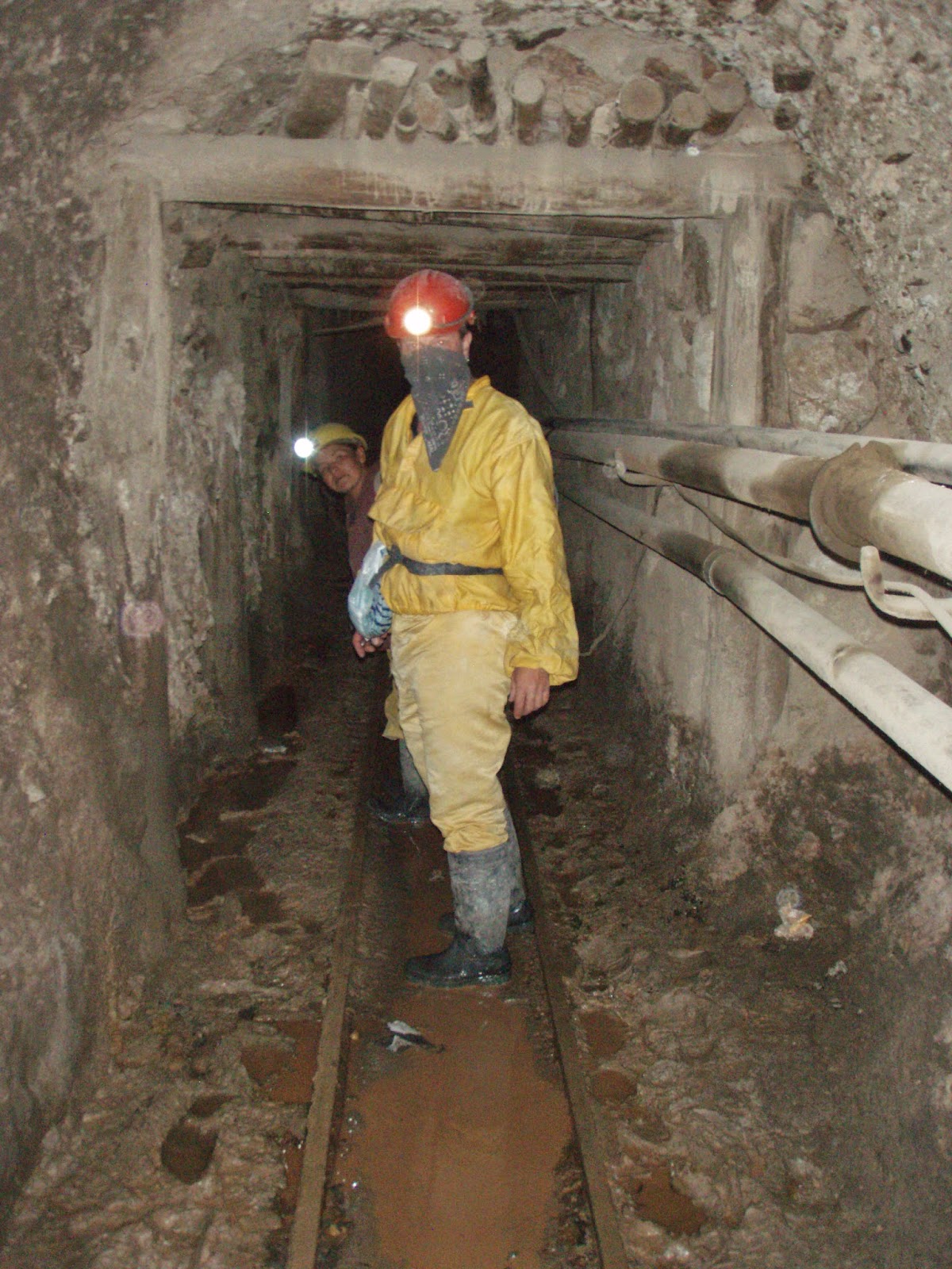
Our main reason for coming to Potosi was to do a tour of the working mines of Cerro Rico. To this day, a workers’ collective extracts minerals from the mine. Due to the lack of protective equipment, the work is still very dangerous. Many miners die in cave-ins or from silicosis, a serious disease that damages the lungs, and there’s been recent concern of the whole mine collapsing. Because of the hellish conditions, many of the miners survive by drinking extremely strong alcohol, chewing coca leaves, and worshipping Tio — a god of the underworld. Sounds like just the spot to me....
 |
| Our first stop was the Mining Market, it is a local market specializing in goods related to the mines; including coca leaves. We bought a bag each to give to the miners. |
 |
| This is hard hellish work in the most deplorable of places. For instance; the tunnels situated higher up in the mountain suffers from temperatures falling to below freezing, whereas further down the mountain the temperature can soar to over 40C. |
 |
| The average age for a Potosi silver miner is 45. In order to survive down here these guys chew on coca leaves. We both bought a bag at the Mining Market to give to the miners. They were truly appreciative. |
 |
| This mountain is honeycomb with over a 1,000 mines dating back to 1545. Some of the passages were downright tiny....this one was a knee crawler. |
 |
| Me and our guide. We can't stop here for long, we have to be aware of the timing of the next 500lb ore-cart which will come barrelling through here at killer speeds and us with no where to go. |
 |
| Tio holds the power of life and death between his fingers. El Tio, meaning “the Uncle,” appears as a devilish creature, and his statues in the mines are given offerings of cigarettes, strong alcohol, and coca leaves. Yes that is coca leaves at his feet. |
 |
| Well that was a sobering way to spend 4 hours. |
We grab a taxi for the 3 hour drive to......
Sucre
Sucre is Bolivia’s most beautiful city and the symbolic heart of the nation. It was here that independence was proclaimed, and while La Paz is now the seat of government and treasury, Sucre is recognized in the constitution as the nation’s capital. A glorious ensemble of whitewashed buildings sheltering pretty patios, it’s a special place that preserves a wealth of colonial architecture. It was declared a Unesco World Heritage site in 1991.
Sucre was supposed to be a stop-over before heading back to La Paz to do some trekking. So today we just did some exploring. Starting at the market....I love markets!
 |
| This market was divided into sections with each section manned by a lady vendor. This was the 'Cheese Lady'. |
 |
| The lowly potato is big in this part of the world and there were no shortage of "Potato Ladies' touting their wears. |
 |
| The ever popular 'Fruit Ladies'. |
 |
| Perhaps the cleanest city in Bolivia with awesome preserved Spanish colonial buildings. |
 |
| One of many archways that lead to other streets. |
 |
| Plaza 25 de Mayo, the main square, with the Cathedral Metropolitana, an ornate colonial church, in the background. |
Later that night we took a steak supper with an English production on the birth of Bolivia....
 |
| We were sitting right next to the stage of this awesome show where each costume change represented another era in Bolivia's history. Here it was the Spanish rule and colonization. |
 |
| An indigenous Shaman from the Amazon Delta which also forms part of the history of Bolivia. |
 |
| The 'ending blend of cultures'. It was a very good steak and an equally good show. |
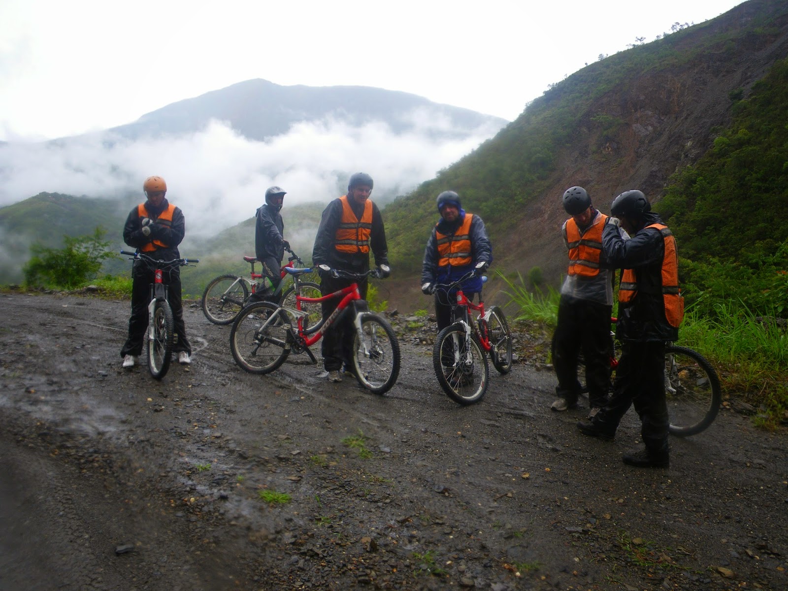
Back in La Paz and the weather has turned for the worse with the rainy season kicking in early. We had one last adventure in us and that was to mountain bike what is known as the World's Most Dangerous Road. The North Yungas Road (also known as the Death Road) is a road leading from La Paz to Coroico, 56 kilometres northeast of La Paz in the Yungas region of Bolivia. In 1995 the Inter-American Development Bank named it as the "world's most dangerous road". In 2006, one estimate stated that 200 to 300 travellers were killed yearly along the road however the road is no longer used for vehicular traffic so the kill rate has dropped to 18 mountain bikers. Gravity feed 64 kilometres of pure downhill with an unbelievable backdrop........
 |
| We gear up at La Cumbre Pass, at 4850 metres, with a sloppy snow falling. Perfect for a suicide bike ride. |
 |
| The road is paved on this portion because it is still used by vehicular traffic. You can see it winding down into the valley. |
 |
| Fortunately we drive out of the snow rather quickly and all we have to contend with now is the torrential downpour! |
 |
| A drug search stop. We have to satisfy the drug police that we weren't smuggling cocaine into one of the biggest cocaine manufacturing districts in South America. The irony! |
 |
| Finally we get to the real start of the trip. The true Most Dangerous Road - Death Road. Thumb up and we are off..... |
 |
| Dramatic 600 metre straight drops on one side and cliff hugging on the other with not a guardrail to be seen. |
 |
| The mist adds to the mystic of the place, allowing us occasional glimpses of our route. |
 |
| Road hazard and carwash at the same time! |
 |
| As we descend into the Amazon jungle the temperature climbs quickly. Time for a pit stop so we can change our wet winter gear into more seasonal soaked gear. |
 |
| Group shot! Yes that would be us way over there in the mist and rain! |
 |
| The road is 64kms long and has a drop of 1,200 metres. Our destination is way down there in the valley. |
 |
| Time for another shower. |
 |
| A gigantic landslide. Little did we know that this is landslide season in Bolivia. |
 |
| Speed bump. Pick up the bikes and lug them across to the other side. |
 |
| End of the road for us. We'd have to paddle back uphill for about 3kms and carry our bikes down an extremely steep path thru thick jungle to get around this one. |
After our bike ride we get fed at a primate refuge. This place is operated by a NGO that looks after injured primates of all shapes, sizes and breed.....
 |
| It was feeding time when we got there so the place was crawling with the primates. |
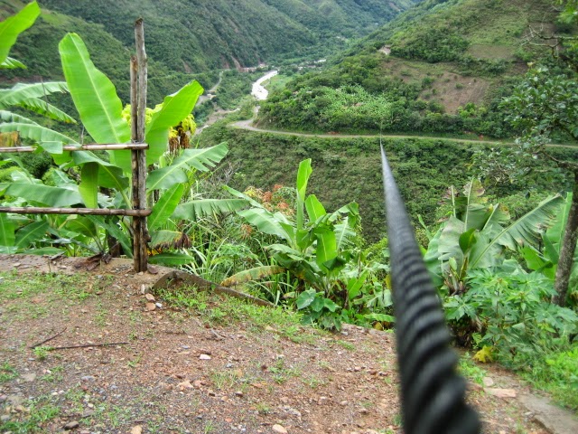
Our last thrill for the day. Ziplining across the valley on three separate ziplines, totalling 1550 metres of line..
 |
| Yes that's the destination way over there.... |
 |
| Each line zig-zags across the valley. |
 |
| Because the lines are so long, you gain speeds up to 85km/hr. And for one brief minute the rain stopped....karma! |
 |
| The smile says it all. Do this again anytime, perhaps when it's not raining! |
Unfortunately, the rains never did let up and our plan trek into the Bolivian Andes had to be put on hold for now. As well, because there were mass destruction from the rains in La Paz, we decided to leave Bolivia and head back to Chile.
Cheers
Diary Entry: Friday February 11, 2011 12:54PM: The day started out with me being very hung-over…..this is the first time this trip.
The bus trip
(February 07/11) from La Paz to Uyuni was horrific. It started out good enough…..they even had a decent movie to watch. And afterwards I fell asleep…..all was good. Until we passed Oruro and then the road (???) went from pavement to practically non-existent. Any hopes of sleep quickly vanished and I literally had the shit shook out of me…..as did everyone else and this made the bus bathroom more like a war zone! We arrived in Uyuni at around 9:30AM and found a cheap hotel at around 10:30AM. We booked a three day tour and settled in for a few beers
On Tuesday
(February 08/11) morning we headed for Salar de Uyuni…..largest salt flats in the world. This time of year they are covered in about an inch of water which makes it the largest mirror in the world. It's an awesome place and driving through it seems like your flying as it is near impossible to distinguish between sky and water. We eventually stopped at a salt hotel where we had lunch and a hour or so to take pictures. Because of the flatness and reflection you can manipulate the picture image and I got a great picture of Paul dancing on a can of beer!! Afterwards we doubled back and passed thru Uyuni and onwards.
The circuit takes in many sites and vistas but the one that captured me the most was the geysers. This no-mans land of steaming vents and boiling mud resembles something out of a sci-fi movie. However at 5,000 metres it was very cold and we did not linger for long. All and all, the tour was quite enjoyable and the sites fantastic.
So now I'm here in Uyuni at an outdoor cafe waiting for the 10:00PM train. The reason I'm hung-over is because last night after getting some money and booking our train trip we went to a bar, met a couple of guys from Ireland and Australia and got on the beer!!


No comments:
Post a Comment